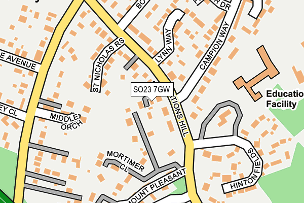
SO23 7GW is located in the The Worthys electoral ward, within the local authority district of Winchester and the English Parliamentary constituency of Winchester. The Sub Integrated Care Board (ICB) Location is NHS Hampshire and Isle of Wight ICB - D9Y0V and the police force is Hampshire. This postcode has been in use since May 2017.


GetTheData
Source: OS OpenMap – Local (Ordnance Survey)
Source: OS VectorMap District (Ordnance Survey)
Licence: Open Government Licence (requires attribution)
| Easting | 449012 |
| Northing | 132881 |
| Latitude | 51.093147 |
| Longitude | -1.301499 |
GetTheData
Source: Open Postcode Geo
Licence: Open Government Licence
| Country | England |
| Postcode District | SO23 |
| ➜ SO23 open data dashboard ➜ See where SO23 is on a map ➜ Where is Headbourne Worthy? | |
GetTheData
Source: Land Registry Price Paid Data
Licence: Open Government Licence
| Ward | The Worthys |
| Constituency | Winchester |
GetTheData
Source: ONS Postcode Database
Licence: Open Government Licence
| June 2022 | Public order | On or near Mount Pleasant | 237m |
| June 2022 | Criminal damage and arson | On or near Frampton Way | 411m |
| May 2022 | Other theft | On or near Boyne Mead Road | 236m |
| ➜ Get more crime data in our Crime section | |||
GetTheData
Source: data.police.uk
Licence: Open Government Licence
| Campion Way (Nations Hill) | Kings Worthy | 50m |
| Campion Way (Nations Hill) | Kings Worthy | 51m |
| Nations Hill (Springvale Road) | Kings Worthy | 269m |
| Nations Hill (Springvale Road) | Kings Worthy | 280m |
| Willis Waye (Church Lane) | Kings Worthy | 316m |
| Winchester Station | 3.2km |
GetTheData
Source: NaPTAN
Licence: Open Government Licence
| Percentage of properties with Next Generation Access | 100.0% |
| Percentage of properties with Superfast Broadband | 100.0% |
| Percentage of properties with Ultrafast Broadband | 100.0% |
| Percentage of properties with Full Fibre Broadband | 0.0% |
Superfast Broadband is between 30Mbps and 300Mbps
Ultrafast Broadband is > 300Mbps
| Percentage of properties unable to receive 2Mbps | 0.0% |
| Percentage of properties unable to receive 5Mbps | 0.0% |
| Percentage of properties unable to receive 10Mbps | 0.0% |
| Percentage of properties unable to receive 30Mbps | 0.0% |
GetTheData
Source: Ofcom
Licence: Ofcom Terms of Use (requires attribution)
GetTheData
Source: ONS Postcode Database
Licence: Open Government Licence


➜ Get more ratings from the Food Standards Agency
GetTheData
Source: Food Standards Agency
Licence: FSA terms & conditions
| Last Collection | |||
|---|---|---|---|
| Location | Mon-Fri | Sat | Distance |
| Kings Worthy Post Office | 17:30 | 10:00 | 557m |
| Headbourne Worthy | 16:30 | 07:45 | 728m |
| Courtney Road | 17:30 | 11:15 | 2,058m |
GetTheData
Source: Dracos
Licence: Creative Commons Attribution-ShareAlike
| Facility | Distance |
|---|---|
| Kings Worthy Primary School Church Lane, Kings Worthy, Winchester Grass Pitches, Sports Hall | 203m |
| Eversley Park Lovedon Lane, Kings Worthy, Winchester Grass Pitches | 442m |
| The Worthies Sports And Social Club Lovedon Lane, Kings Worthy, Winchester Grass Pitches | 510m |
GetTheData
Source: Active Places
Licence: Open Government Licence
| School | Phase of Education | Distance |
|---|---|---|
| Kings Worthy Primary School Church Lane, Kings Worthy, Winchester, SO23 7QS | Primary | 221m |
| Prince's Mead School Worthy Park House, Kings Worthy, Winchester, Hampshire, SO21 1AN | Not applicable | 1.1km |
| Barton Farm Primary Academy Barton Farm Primary Academy, Glazier Road, Kings Barton, Winchester, SO22 6HS | Primary | 1.9km |
GetTheData
Source: Edubase
Licence: Open Government Licence
The below table lists the International Territorial Level (ITL) codes (formerly Nomenclature of Territorial Units for Statistics (NUTS) codes) and Local Administrative Units (LAU) codes for SO23 7GW:
| ITL 1 Code | Name |
|---|---|
| TLJ | South East (England) |
| ITL 2 Code | Name |
| TLJ3 | Hampshire and Isle of Wight |
| ITL 3 Code | Name |
| TLJ36 | Central Hampshire |
| LAU 1 Code | Name |
| E07000094 | Winchester |
GetTheData
Source: ONS Postcode Directory
Licence: Open Government Licence
The below table lists the Census Output Area (OA), Lower Layer Super Output Area (LSOA), and Middle Layer Super Output Area (MSOA) for SO23 7GW:
| Code | Name | |
|---|---|---|
| OA | E00118246 | |
| LSOA | E01023274 | Winchester 003E |
| MSOA | E02004831 | Winchester 003 |
GetTheData
Source: ONS Postcode Directory
Licence: Open Government Licence
| SO23 7QY | Nations Hill | 104m |
| SO23 7SY | St Nicholas Rise | 112m |
| SO23 7QX | Mortimer Close | 124m |
| SO23 7TG | Lynn Way | 164m |
| SO23 7FP | Middle Orchard | 173m |
| SO23 7QU | Mount Pleasant | 182m |
| SO23 7QB | Hinton Fields | 192m |
| SO23 7LF | Springvale Road | 197m |
| SO23 7QP | Campion Way | 220m |
| SO23 7XL | Headbourne Close | 222m |
GetTheData
Source: Open Postcode Geo; Land Registry Price Paid Data
Licence: Open Government Licence