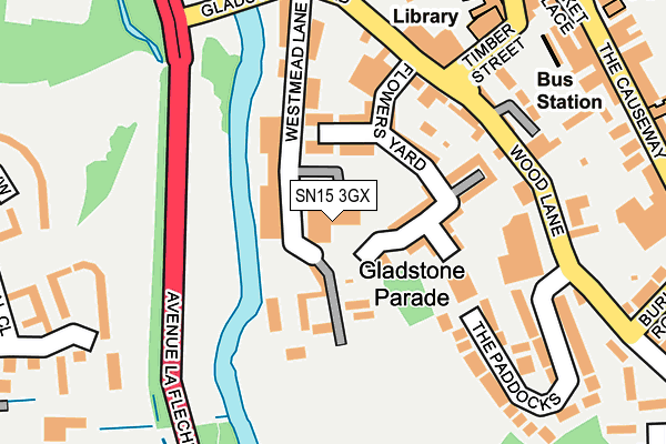
SN15 3GX is located in the Chippenham Hardens & Central electoral ward, within the unitary authority of Wiltshire and the English Parliamentary constituency of Chippenham. The Sub Integrated Care Board (ICB) Location is NHS Bath and North East Somerset, Swindon and Wiltshire ICB - 92 and the police force is Wiltshire. This postcode has been in use since June 2017.


GetTheData
Source: OS OpenMap – Local (Ordnance Survey)
Source: OS VectorMap District (Ordnance Survey)
Licence: Open Government Licence (requires attribution)
| Easting | 392002 |
| Northing | 172976 |
| Latitude | 51.455705 |
| Longitude | -2.116494 |
GetTheData
Source: Open Postcode Geo
Licence: Open Government Licence
| Country | England |
| Postcode District | SN15 |
➜ See where SN15 is on a map ➜ Where is Chippenham? | |
GetTheData
Source: Land Registry Price Paid Data
Licence: Open Government Licence
| Ward | Chippenham Hardens & Central |
| Constituency | Chippenham |
GetTheData
Source: ONS Postcode Database
Licence: Open Government Licence
| Angel Hotel (Gladstone Road) | Chippenham | 187m |
| Angel Hotel (Gladstone Road) | Chippenham | 201m |
| Town Bridge (Bath Road) | Chippenham | 405m |
| Town Bridge (The Bridge) | Chippenham | 439m |
| Charter Road (Rowden Hill) | Chippenham | 441m |
| Chippenham Station | 0.8km |
GetTheData
Source: NaPTAN
Licence: Open Government Licence
| Percentage of properties with Next Generation Access | 0.0% |
| Percentage of properties with Superfast Broadband | 0.0% |
| Percentage of properties with Ultrafast Broadband | 0.0% |
| Percentage of properties with Full Fibre Broadband | 0.0% |
Superfast Broadband is between 30Mbps and 300Mbps
Ultrafast Broadband is > 300Mbps
| Median download speed | 16.8Mbps |
| Average download speed | 14.9Mbps |
| Maximum download speed | 19.80Mbps |
| Median upload speed | 1.1Mbps |
| Average upload speed | 1.0Mbps |
| Maximum upload speed | 1.26Mbps |
| Percentage of properties unable to receive 2Mbps | 0.0% |
| Percentage of properties unable to receive 5Mbps | 0.0% |
| Percentage of properties unable to receive 10Mbps | 0.0% |
| Percentage of properties unable to receive 30Mbps | 100.0% |
GetTheData
Source: Ofcom
Licence: Ofcom Terms of Use (requires attribution)
GetTheData
Source: ONS Postcode Database
Licence: Open Government Licence


➜ Get more ratings from the Food Standards Agency
GetTheData
Source: Food Standards Agency
Licence: FSA terms & conditions
| Last Collection | |||
|---|---|---|---|
| Location | Mon-Fri | Sat | Distance |
| Chippenham Branch Office | 18:30 | 12:30 | 335m |
| The Bridge | 17:30 | 12:30 | 368m |
| London Road | 17:30 | 12:00 | 406m |
GetTheData
Source: Dracos
Licence: Creative Commons Attribution-ShareAlike
| Risk of SN15 3GX flooding from rivers and sea | Low |
| ➜ SN15 3GX flood map | |
GetTheData
Source: Open Flood Risk by Postcode
Licence: Open Government Licence
The below table lists the International Territorial Level (ITL) codes (formerly Nomenclature of Territorial Units for Statistics (NUTS) codes) and Local Administrative Units (LAU) codes for SN15 3GX:
| ITL 1 Code | Name |
|---|---|
| TLK | South West (England) |
| ITL 2 Code | Name |
| TLK1 | Gloucestershire, Wiltshire and Bath/Bristol area |
| ITL 3 Code | Name |
| TLK15 | Wiltshire |
| LAU 1 Code | Name |
| E06000054 | Wiltshire |
GetTheData
Source: ONS Postcode Directory
Licence: Open Government Licence
The below table lists the Census Output Area (OA), Lower Layer Super Output Area (LSOA), and Middle Layer Super Output Area (MSOA) for SN15 3GX:
| Code | Name | |
|---|---|---|
| OA | E00166438 | |
| LSOA | E01031912 | Wiltshire 011B |
| MSOA | E02006654 | Wiltshire 011 |
GetTheData
Source: ONS Postcode Directory
Licence: Open Government Licence
| SN15 3GU | Westmead Lane | 59m |
| SN15 3BU | Louise Rayner Place | 84m |
| SN15 3BN | Flowers Yard | 92m |
| SN15 3HS | Fuller Close | 106m |
| SN15 3YW | Victorias Place | 119m |
| SN15 3HZ | Westmead Lane | 123m |
| SN15 3BW | Gladstone Road | 144m |
| SN15 3DQ | Wood Lane | 164m |
| SN15 3YY | Gladstone Road | 180m |
| SN15 3BS | Timber Street | 187m |
GetTheData
Source: Open Postcode Geo; Land Registry Price Paid Data
Licence: Open Government Licence