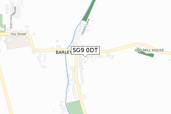
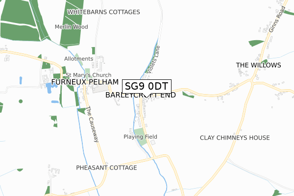
SG9 0DT is located in the Little Hadham & The Pelhams electoral ward, within the local authority district of East Hertfordshire and the English Parliamentary constituency of North East Hertfordshire. The Sub Integrated Care Board (ICB) Location is NHS Hertfordshire and West Essex ICB - 06K and the police force is Hertfordshire. This postcode has been in use since October 2017.


GetTheData
Source: OS Open Zoomstack (Ordnance Survey)
Licence: Open Government Licence (requires attribution)
Attribution: Contains OS data © Crown copyright and database right 2024
Source: Open Postcode Geo
Licence: Open Government Licence (requires attribution)
Attribution: Contains OS data © Crown copyright and database right 2024; Contains Royal Mail data © Royal Mail copyright and database right 2024; Source: Office for National Statistics licensed under the Open Government Licence v.3.0
| Easting | 543660 |
| Northing | 227788 |
| Latitude | 51.930081 |
| Longitude | 0.088043 |
GetTheData
Source: Open Postcode Geo
Licence: Open Government Licence
| Country | England |
| Postcode District | SG9 |
| ➜ SG9 open data dashboard ➜ See where SG9 is on a map ➜ Where is Barleycroft End? | |
GetTheData
Source: Land Registry Price Paid Data
Licence: Open Government Licence
| Ward | Little Hadham & The Pelhams |
| Constituency | North East Hertfordshire |
GetTheData
Source: ONS Postcode Database
Licence: Open Government Licence
| March 2022 | Anti-social behaviour | On or near Sports/Recreation Area | 338m |
| January 2022 | Public order | On or near The Street | 405m |
| December 2021 | Violence and sexual offences | On or near Sports/Recreation Area | 338m |
| ➜ Get more crime data in our Crime section | |||
GetTheData
Source: data.police.uk
Licence: Open Government Licence
| Brewery Tap Ph (Unknown) | Furneux Pelham | 61m |
| Brewery Tap Ph (Barleycroft End) | Furneux Pelham | 111m |
| The Street | Furneux Pelham | 440m |
| The Street | Furneux Pelham | 444m |
| Whitebarns Lane | Furneux Pelham | 512m |
GetTheData
Source: NaPTAN
Licence: Open Government Licence
➜ Broadband speed and availability dashboard for SG9 0DT
| Percentage of properties with Next Generation Access | 100.0% |
| Percentage of properties with Superfast Broadband | 100.0% |
| Percentage of properties with Ultrafast Broadband | 0.0% |
| Percentage of properties with Full Fibre Broadband | 0.0% |
Superfast Broadband is between 30Mbps and 300Mbps
Ultrafast Broadband is > 300Mbps
| Median download speed | 80.0Mbps |
| Average download speed | 71.4Mbps |
| Maximum download speed | 80.00Mbps |
| Median upload speed | 20.0Mbps |
| Average upload speed | 17.9Mbps |
| Maximum upload speed | 20.00Mbps |
| Percentage of properties unable to receive 2Mbps | 0.0% |
| Percentage of properties unable to receive 5Mbps | 0.0% |
| Percentage of properties unable to receive 10Mbps | 0.0% |
| Percentage of properties unable to receive 30Mbps | 0.0% |
➜ Broadband speed and availability dashboard for SG9 0DT
GetTheData
Source: Ofcom
Licence: Ofcom Terms of Use (requires attribution)
GetTheData
Source: ONS Postcode Database
Licence: Open Government Licence


➜ Get more ratings from the Food Standards Agency
GetTheData
Source: Food Standards Agency
Licence: FSA terms & conditions
| Last Collection | |||
|---|---|---|---|
| Location | Mon-Fri | Sat | Distance |
| Barleycroft End | 16:15 | 09:15 | 60m |
| Furneaux Pelham Church | 16:15 | 09:00 | 495m |
| East End | 16:45 | 10:15 | 901m |
GetTheData
Source: Dracos
Licence: Creative Commons Attribution-ShareAlike
| Facility | Distance |
|---|---|
| Brewery Field Furneux Pelham, Buntingford Grass Pitches | 332m |
| Albury Football Ground Church End, Albury, Ware Grass Pitches | 3km |
| Braughing Playing Fields Green Lane, Braughing Grass Pitches, Sports Hall, Outdoor Tennis Courts | 4.6km |
GetTheData
Source: Active Places
Licence: Open Government Licence
| School | Phase of Education | Distance |
|---|---|---|
| Furneux Pelham Church of England School Furneux Pelham School, Furneux Pelham, SG9 0LH | Primary | 455m |
| Albury Church of England Voluntary Aided Primary School Church End, Albury, SG11 2JQ | Primary | 3.1km |
| Hormead Church of England (VA) First School Great Hormead, Buntingford, SG9 0NR | Primary | 4.4km |
GetTheData
Source: Edubase
Licence: Open Government Licence
The below table lists the International Territorial Level (ITL) codes (formerly Nomenclature of Territorial Units for Statistics (NUTS) codes) and Local Administrative Units (LAU) codes for SG9 0DT:
| ITL 1 Code | Name |
|---|---|
| TLH | East |
| ITL 2 Code | Name |
| TLH2 | Bedfordshire and Hertfordshire |
| ITL 3 Code | Name |
| TLH23 | Hertfordshire CC |
| LAU 1 Code | Name |
| E07000242 | East Hertfordshire |
GetTheData
Source: ONS Postcode Directory
Licence: Open Government Licence
The below table lists the Census Output Area (OA), Lower Layer Super Output Area (LSOA), and Middle Layer Super Output Area (MSOA) for SG9 0DT:
| Code | Name | |
|---|---|---|
| OA | E00119329 | |
| LSOA | E01023493 | East Hertfordshire 003F |
| MSOA | E02004880 | East Hertfordshire 003 |
GetTheData
Source: ONS Postcode Directory
Licence: Open Government Licence
| SG9 0LG | Lake Villas | 50m |
| SG9 0TS | The Old Brewery | 135m |
| SG9 0LQ | The Old Common | 141m |
| SG9 0LL | 151m | |
| SG9 0LF | Violets Lane | 154m |
| SG9 0LJ | 329m | |
| SG9 0JH | Whitebarns | 491m |
| SG9 0LH | 507m | |
| SG9 0LW | The Causeway | 527m |
| SG9 0LN | The Causeway | 536m |
GetTheData
Source: Open Postcode Geo; Land Registry Price Paid Data
Licence: Open Government Licence