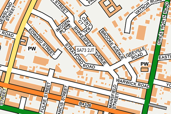
SA73 2JT is located in the Milford: Central electoral ward, within the unitary authority of Pembrokeshire and the Welsh Parliamentary constituency of Preseli Pembrokeshire. The Local Health Board is Hywel Dda University and the police force is Dyfed-Powys. This postcode has been in use since April 2017.


GetTheData
Source: OS OpenMap – Local (Ordnance Survey)
Source: OS VectorMap District (Ordnance Survey)
Licence: Open Government Licence (requires attribution)
| Easting | 190635 |
| Northing | 206056 |
| Latitude | 51.714072 |
| Longitude | -5.032126 |
GetTheData
Source: Open Postcode Geo
Licence: Open Government Licence
| Country | Wales |
| Postcode District | SA73 |
| ➜ SA73 open data dashboard ➜ See where SA73 is on a map ➜ Where is Milford Haven? | |
GetTheData
Source: Land Registry Price Paid Data
Licence: Open Government Licence
| Ward | Milford: Central |
| Constituency | Preseli Pembrokeshire |
GetTheData
Source: ONS Postcode Database
Licence: Open Government Licence
| January 2024 | Violence and sexual offences | On or near Parking Area | 70m |
| January 2024 | Other theft | On or near Parking Area | 421m |
| December 2023 | Criminal damage and arson | On or near Parking Area | 421m |
| ➜ Get more crime data in our Crime section | |||
GetTheData
Source: data.police.uk
Licence: Open Government Licence
| Robert Street | Milford Haven | 129m |
| Fulke Street (Robert Street) | Milford Haven | 160m |
| Quakers (Priory Road) | Milford Haven | 261m |
| Great North Road (Greath North Road) | Pill | 272m |
| Great North Road | Milford Haven | 277m |
| Milford Haven Station | 0.6km |
| Johnston (Pembrokeshire) Station | 5.4km |
GetTheData
Source: NaPTAN
Licence: Open Government Licence
| Percentage of properties with Next Generation Access | 100.0% |
| Percentage of properties with Superfast Broadband | 100.0% |
| Percentage of properties with Ultrafast Broadband | 0.0% |
| Percentage of properties with Full Fibre Broadband | 0.0% |
Superfast Broadband is between 30Mbps and 300Mbps
Ultrafast Broadband is > 300Mbps
| Percentage of properties unable to receive 2Mbps | 0.0% |
| Percentage of properties unable to receive 5Mbps | 0.0% |
| Percentage of properties unable to receive 10Mbps | 0.0% |
| Percentage of properties unable to receive 30Mbps | 0.0% |
GetTheData
Source: Ofcom
Licence: Ofcom Terms of Use (requires attribution)
GetTheData
Source: ONS Postcode Database
Licence: Open Government Licence


➜ Get more ratings from the Food Standards Agency
GetTheData
Source: Food Standards Agency
Licence: FSA terms & conditions
| Last Collection | |||
|---|---|---|---|
| Location | Mon-Fri | Sat | Distance |
| Mastlebridge | 12:00 | 12:00 | 4,823m |
| Rosemarket P O | 12:00 | 12:00 | 5,123m |
GetTheData
Source: Dracos
Licence: Creative Commons Attribution-ShareAlike
| School | Phase of Education | Distance |
|---|---|---|
| Milford Haven Community Primary School Prioryville, Milford Haven, SA73 2LQ | Not applicable | 204m |
| St Francis V.R.C. School Priory Road, Milford Haven, Pembrokeshire, SA73 2EE | Not applicable | 474m |
| Milford Haven School Steynton Road, Milford Haven, Pembrokeshire, SA73 1AE | Not applicable | 1.3km |
GetTheData
Source: Edubase
Licence: Open Government Licence
The below table lists the International Territorial Level (ITL) codes (formerly Nomenclature of Territorial Units for Statistics (NUTS) codes) and Local Administrative Units (LAU) codes for SA73 2JT:
| ITL 1 Code | Name |
|---|---|
| TLL | Wales |
| ITL 2 Code | Name |
| TLL1 | West Wales and The Valleys |
| ITL 3 Code | Name |
| TLL14 | South West Wales |
| LAU 1 Code | Name |
| W06000009 | Pembrokeshire |
GetTheData
Source: ONS Postcode Directory
Licence: Open Government Licence
The below table lists the Census Output Area (OA), Lower Layer Super Output Area (LSOA), and Middle Layer Super Output Area (MSOA) for SA73 2JT:
| Code | Name | |
|---|---|---|
| OA | W00003141 | |
| LSOA | W01000587 | Pembrokeshire 010A |
| MSOA | W02000135 | Pembrokeshire 010 |
GetTheData
Source: ONS Postcode Directory
Licence: Open Government Licence
| SA73 2JJ | Shakespeare Avenue | 39m |
| SA73 2JL | Shakespeare Avenue | 58m |
| SA73 2JD | Stratford Road | 59m |
| SA73 2JA | Stratford Road | 67m |
| SA73 2HS | Robert Street | 91m |
| SA73 2JF | Stratford Road | 91m |
| SA73 2LS | Brooke Avenue | 119m |
| SA73 2JH | Shakespeare Avenue | 122m |
| SA73 2HT | Robert Street | 128m |
| SA73 2HX | Robert Street | 134m |
GetTheData
Source: Open Postcode Geo; Land Registry Price Paid Data
Licence: Open Government Licence