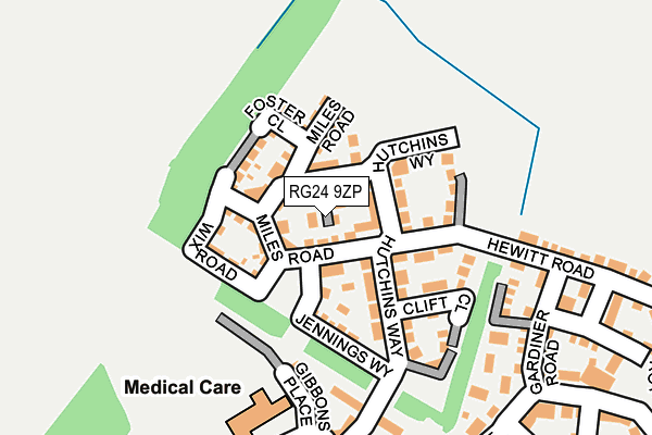
RG24 9ZP is located in the Sherborne St John & Rooksdown electoral ward, within the local authority district of Basingstoke and Deane and the English Parliamentary constituency of North East Hampshire. The Sub Integrated Care Board (ICB) Location is NHS Hampshire and Isle of Wight ICB - D9Y0V and the police force is Hampshire. This postcode has been in use since March 2017.


GetTheData
Source: OS OpenMap – Local (Ordnance Survey)
Source: OS VectorMap District (Ordnance Survey)
Licence: Open Government Licence (requires attribution)
| Easting | 463467 |
| Northing | 154993 |
| Latitude | 51.290543 |
| Longitude | -1.091208 |
GetTheData
Source: Open Postcode Geo
Licence: Open Government Licence
| Country | England |
| Postcode District | RG24 |
| ➜ RG24 open data dashboard ➜ See where RG24 is on a map ➜ Where is Basingstoke? | |
GetTheData
Source: Land Registry Price Paid Data
Licence: Open Government Licence
| Ward | Sherborne St John & Rooksdown |
| Constituency | North East Hampshire |
GetTheData
Source: ONS Postcode Database
Licence: Open Government Licence
6, WYETH ROAD, BASINGSTOKE, RG24 9ZP 2017 30 NOV £367,000 |
8, WYETH ROAD, BASINGSTOKE, RG24 9ZP 2017 24 NOV £340,000 |
4, WYETH ROAD, BASINGSTOKE, RG24 9ZP 2017 24 NOV £367,000 |
15, WYETH ROAD, BASINGSTOKE, RG24 9ZP 2017 31 MAR £340,000 |
GetTheData
Source: HM Land Registry Price Paid Data
Licence: Contains HM Land Registry data © Crown copyright and database right 2024. This data is licensed under the Open Government Licence v3.0.
| December 2023 | Anti-social behaviour | On or near Gardiner Road | 238m |
| September 2023 | Anti-social behaviour | On or near Gardiner Road | 238m |
| August 2023 | Violence and sexual offences | On or near Benham Road | 427m |
| ➜ Get more crime data in our Crime section | |||
GetTheData
Source: data.police.uk
Licence: Open Government Licence
| Englefield Way (Appleton Drive) | Popley | 266m |
| Appleton Bridge (Appleton Drive) | Popley | 273m |
| Englefield Way (Appleton Drive) | Popley | 281m |
| Appleton Bridge (Appleton Drive) | Popley | 287m |
| Carter Drive (Oxford Way) | Popley | 336m |
| Basingstoke Station | 2.5km |
| Bramley (Hants) Station | 4.9km |
GetTheData
Source: NaPTAN
Licence: Open Government Licence
| Percentage of properties with Next Generation Access | 100.0% |
| Percentage of properties with Superfast Broadband | 100.0% |
| Percentage of properties with Ultrafast Broadband | 100.0% |
| Percentage of properties with Full Fibre Broadband | 100.0% |
Superfast Broadband is between 30Mbps and 300Mbps
Ultrafast Broadband is > 300Mbps
| Percentage of properties unable to receive 2Mbps | 0.0% |
| Percentage of properties unable to receive 5Mbps | 0.0% |
| Percentage of properties unable to receive 10Mbps | 0.0% |
| Percentage of properties unable to receive 30Mbps | 0.0% |
GetTheData
Source: Ofcom
Licence: Ofcom Terms of Use (requires attribution)
GetTheData
Source: ONS Postcode Database
Licence: Open Government Licence

➜ Get more ratings from the Food Standards Agency
GetTheData
Source: Food Standards Agency
Licence: FSA terms & conditions
| Last Collection | |||
|---|---|---|---|
| Location | Mon-Fri | Sat | Distance |
| Abbey Court | 16:45 | 11:00 | 767m |
| Carpenters Down | 16:45 | 11:15 | 773m |
| Popley Way | 17:00 | 11:00 | 822m |
GetTheData
Source: Dracos
Licence: Creative Commons Attribution-ShareAlike
| Facility | Distance |
|---|---|
| The Everest Health & Leisure Club Oxford Way, Basingstoke Sports Hall, Health and Fitness Gym, Artificial Grass Pitch, Grass Pitches, Studio, Outdoor Tennis Courts | 684m |
| John Hunt Of Everest Community School (Closed) Popley Way, Basingstoke Sports Hall, Grass Pitches | 939m |
| Chute Recreation Ground Vyne Road, Sherborne St John Grass Pitches, Outdoor Tennis Courts | 942m |
GetTheData
Source: Active Places
Licence: Open Government Licence
| School | Phase of Education | Distance |
|---|---|---|
| Everest Community Academy Oxford Way, Basingstoke, RG24 9UP | Secondary | 684m |
| St Bede's Catholic Primary School Popley Way, Basingstoke, RG24 9DX | Primary | 714m |
| Merton Junior School Romsey Close, Popley Way, Basingstoke, RG24 9HB | Primary | 1km |
GetTheData
Source: Edubase
Licence: Open Government Licence
The below table lists the International Territorial Level (ITL) codes (formerly Nomenclature of Territorial Units for Statistics (NUTS) codes) and Local Administrative Units (LAU) codes for RG24 9ZP:
| ITL 1 Code | Name |
|---|---|
| TLJ | South East (England) |
| ITL 2 Code | Name |
| TLJ3 | Hampshire and Isle of Wight |
| ITL 3 Code | Name |
| TLJ37 | North Hampshire |
| LAU 1 Code | Name |
| E07000084 | Basingstoke and Deane |
GetTheData
Source: ONS Postcode Directory
Licence: Open Government Licence
The below table lists the Census Output Area (OA), Lower Layer Super Output Area (LSOA), and Middle Layer Super Output Area (MSOA) for RG24 9ZP:
| Code | Name | |
|---|---|---|
| OA | E00114624 | |
| LSOA | E01022546 | Basingstoke and Deane 005D |
| MSOA | E02004679 | Basingstoke and Deane 005 |
GetTheData
Source: ONS Postcode Directory
Licence: Open Government Licence
| RG24 9UN | Hutchins Way | 92m |
| RG24 9ZE | Jennings Way | 127m |
| RG24 9UR | Gibbons Place | 191m |
| RG24 9FL | Hewitt Road | 194m |
| RG24 9FH | Gardiner Road | 229m |
| RG24 9FG | Egerton Drive | 257m |
| RG24 9RX | Appleton Drive | 258m |
| RG24 9UL | Carter Drive | 271m |
| RG24 9FQ | Taplin Close | 347m |
| RG24 9FN | Merryweather Way | 361m |
GetTheData
Source: Open Postcode Geo; Land Registry Price Paid Data
Licence: Open Government Licence