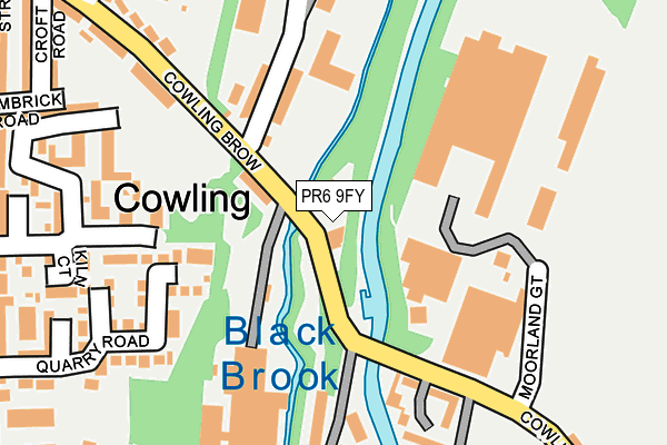
PR6 9FY is located in the Chorley East electoral ward, within the local authority district of Chorley and the English Parliamentary constituency of Chorley. The Sub Integrated Care Board (ICB) Location is NHS Lancashire and South Cumbria ICB - 00X and the police force is Lancashire. This postcode has been in use since March 2017.


GetTheData
Source: OS OpenMap – Local (Ordnance Survey)
Source: OS VectorMap District (Ordnance Survey)
Licence: Open Government Licence (requires attribution)
| Easting | 359608 |
| Northing | 416937 |
| Latitude | 53.647385 |
| Longitude | -2.612511 |
GetTheData
Source: Open Postcode Geo
Licence: Open Government Licence
| Country | England |
| Postcode District | PR6 |
| ➜ PR6 open data dashboard ➜ See where PR6 is on a map ➜ Where is Chorley? | |
GetTheData
Source: Land Registry Price Paid Data
Licence: Open Government Licence
| Ward | Chorley East |
| Constituency | Chorley |
GetTheData
Source: ONS Postcode Database
Licence: Open Government Licence
| December 2023 | Anti-social behaviour | On or near Sackville Street | 469m |
| December 2023 | Anti-social behaviour | On or near Sackville Street | 469m |
| December 2023 | Violence and sexual offences | On or near Sackville Street | 469m |
| ➜ Get more crime data in our Crime section | |||
GetTheData
Source: data.police.uk
Licence: Open Government Licence
| Crosse Hall Street (Cowling Brow) | Cowling | 45m |
| Fdc Relief (Moorland Gate) | Cowling | 177m |
| Spinners Arms (Cowling Road) | Cowling | 287m |
| Spinners Arms (Cowling Road) | Cowling | 292m |
| Brookes Arms (Eaves Lane) | Eaves Lane | 433m |
| Chorley Station | 1.1km |
| Adlington (Lancs) Station | 3.8km |
| Euxton Balshaw Lane Station | 4.2km |
GetTheData
Source: NaPTAN
Licence: Open Government Licence
GetTheData
Source: ONS Postcode Database
Licence: Open Government Licence


➜ Get more ratings from the Food Standards Agency
GetTheData
Source: Food Standards Agency
Licence: FSA terms & conditions
| Last Collection | |||
|---|---|---|---|
| Location | Mon-Fri | Sat | Distance |
| Bolton Road Post Office | 16:30 | 11:30 | 717m |
| Devonshire Road Post Office | 17:30 | 11:30 | 733m |
| Limbrick | 16:30 | 10:30 | 764m |
GetTheData
Source: Dracos
Licence: Creative Commons Attribution-ShareAlike
| Facility | Distance |
|---|---|
| Old Mill Leisure Indoor Bowls Club (Closed) Cowling Brow, Chorley Indoor Bowls | 224m |
| Albany Academy Bolton Road, Chorley Grass Pitches, Sports Hall, Outdoor Tennis Courts | 632m |
| Gillett Playing Fields Weavers Brow, Heath Charnock Grass Pitches | 635m |
GetTheData
Source: Active Places
Licence: Open Government Licence
| School | Phase of Education | Distance |
|---|---|---|
| Sacred Heart Catholic Primary School, Chorley Brooke Street, Chorley, PR6 0LB | Primary | 593m |
| Albany Academy Bolton Road, Chorley, PR7 3AY | Secondary | 654m |
| Chorley St James' Church of England Primary School Devonport Way, Chorley, PR6 0TE | Primary | 669m |
GetTheData
Source: Edubase
Licence: Open Government Licence
The below table lists the International Territorial Level (ITL) codes (formerly Nomenclature of Territorial Units for Statistics (NUTS) codes) and Local Administrative Units (LAU) codes for PR6 9FY:
| ITL 1 Code | Name |
|---|---|
| TLD | North West (England) |
| ITL 2 Code | Name |
| TLD4 | Lancashire |
| ITL 3 Code | Name |
| TLD47 | Chorley and West Lancashire |
| LAU 1 Code | Name |
| E07000118 | Chorley |
GetTheData
Source: ONS Postcode Directory
Licence: Open Government Licence
The below table lists the Census Output Area (OA), Lower Layer Super Output Area (LSOA), and Middle Layer Super Output Area (MSOA) for PR6 9FY:
| Code | Name | |
|---|---|---|
| OA | E00126518 | |
| LSOA | E01024926 | Chorley 009B |
| MSOA | E02005197 | Chorley 009 |
GetTheData
Source: ONS Postcode Directory
Licence: Open Government Licence
| PR6 9DU | Bridge Mill Court | 179m |
| PR6 0NU | Fell View | 192m |
| PR6 0QG | Cowling Brow | 192m |
| PR6 0LR | Quarry Road | 205m |
| PR6 0LS | Quarry Close | 236m |
| PR6 0NT | Fell View | 253m |
| PR6 0QF | Cowling Brow | 259m |
| PR6 0LT | Hornby Road | 272m |
| PR6 0LZ | Limbrick Road | 275m |
| PR6 0LU | Yarrow Road | 300m |
GetTheData
Source: Open Postcode Geo; Land Registry Price Paid Data
Licence: Open Government Licence