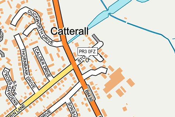
PR3 0FZ is located in the Brock with Catterall electoral ward, within the local authority district of Wyre and the English Parliamentary constituency of Wyre and Preston North. The Sub Integrated Care Board (ICB) Location is NHS Lancashire and South Cumbria ICB - 02M and the police force is Lancashire. This postcode has been in use since April 2017.


GetTheData
Source: OS OpenMap – Local (Ordnance Survey)
Source: OS VectorMap District (Ordnance Survey)
Licence: Open Government Licence (requires attribution)
| Easting | 350019 |
| Northing | 442864 |
| Latitude | 53.879564 |
| Longitude | -2.761765 |
GetTheData
Source: Open Postcode Geo
Licence: Open Government Licence
| Country | England |
| Postcode District | PR3 |
➜ See where PR3 is on a map ➜ Where is Catterall? | |
GetTheData
Source: Land Registry Price Paid Data
Licence: Open Government Licence
| Ward | Brock With Catterall |
| Constituency | Wyre And Preston North |
GetTheData
Source: ONS Postcode Database
Licence: Open Government Licence
2022 5 JUL £460,000 |
8, PICKERING GARDENS, CATTERALL, PRESTON, PR3 0FZ 2018 7 DEC £340,000 |
4, PICKERING GARDENS, CATTERALL, PRESTON, PR3 0FZ 2018 13 APR £352,000 |
2018 22 JAN £380,000 |
3, PICKERING GARDENS, CATTERALL, PRESTON, PR3 0FZ 2017 6 NOV £340,000 |
6, PICKERING GARDENS, CATTERALL, PRESTON, PR3 0FZ 2017 2 NOV £355,000 |
10, PICKERING GARDENS, CATTERALL, PRESTON, PR3 0FZ 2017 29 AUG £450,000 |
9, PICKERING GARDENS, CATTERALL, PRESTON, PR3 0FZ 2017 25 AUG £399,950 |
5, PICKERING GARDENS, CATTERALL, PRESTON, PR3 0FZ 2017 16 AUG £355,000 |
2, PICKERING GARDENS, CATTERALL, PRESTON, PR3 0FZ 2017 14 JUL £354,000 |
GetTheData
Source: HM Land Registry Price Paid Data
Licence: Contains HM Land Registry data © Crown copyright and database right 2025. This data is licensed under the Open Government Licence v3.0.
| Pickering Park Hotel (Garstang Road) | Catterall | 64m |
| Pickering Park Hotel (Garstang Road) | Catterall | 129m |
| Calder Drive (Cock Robin Lane) | Catterall | 160m |
| Joe Lane (Preston Lancaster Old Road) | Catterall | 180m |
| Calder Drive (Cock Robin Lane) | Catterall | 193m |
GetTheData
Source: NaPTAN
Licence: Open Government Licence
| Percentage of properties with Next Generation Access | 100.0% |
| Percentage of properties with Superfast Broadband | 100.0% |
| Percentage of properties with Ultrafast Broadband | 0.0% |
| Percentage of properties with Full Fibre Broadband | 0.0% |
Superfast Broadband is between 30Mbps and 300Mbps
Ultrafast Broadband is > 300Mbps
| Median download speed | 74.8Mbps |
| Average download speed | 65.8Mbps |
| Maximum download speed | 79.98Mbps |
| Median upload speed | 20.0Mbps |
| Average upload speed | 17.0Mbps |
| Maximum upload speed | 20.00Mbps |
| Percentage of properties unable to receive 2Mbps | 0.0% |
| Percentage of properties unable to receive 5Mbps | 0.0% |
| Percentage of properties unable to receive 10Mbps | 0.0% |
| Percentage of properties unable to receive 30Mbps | 0.0% |
GetTheData
Source: Ofcom
Licence: Ofcom Terms of Use (requires attribution)
GetTheData
Source: ONS Postcode Database
Licence: Open Government Licence

➜ Get more ratings from the Food Standards Agency
GetTheData
Source: Food Standards Agency
Licence: FSA terms & conditions
| Last Collection | |||
|---|---|---|---|
| Location | Mon-Fri | Sat | Distance |
| Joe Lane | 17:00 | 10:30 | 207m |
| Catterall Post Office | 17:00 | 10:30 | 400m |
| Garstang Delivery Office | 18:00 | 12:15 | 2,416m |
GetTheData
Source: Dracos
Licence: Creative Commons Attribution-ShareAlike
The below table lists the International Territorial Level (ITL) codes (formerly Nomenclature of Territorial Units for Statistics (NUTS) codes) and Local Administrative Units (LAU) codes for PR3 0FZ:
| ITL 1 Code | Name |
|---|---|
| TLD | North West (England) |
| ITL 2 Code | Name |
| TLD4 | Lancashire |
| ITL 3 Code | Name |
| TLD44 | Lancaster and Wyre |
| LAU 1 Code | Name |
| E07000128 | Wyre |
GetTheData
Source: ONS Postcode Directory
Licence: Open Government Licence
The below table lists the Census Output Area (OA), Lower Layer Super Output Area (LSOA), and Middle Layer Super Output Area (MSOA) for PR3 0FZ:
| Code | Name | |
|---|---|---|
| OA | E00129668 | |
| LSOA | E01025553 | Wyre 007B |
| MSOA | E02005325 | Wyre 007 |
GetTheData
Source: ONS Postcode Directory
Licence: Open Government Licence
| PR3 0HD | Garstang Road | 84m |
| PR3 0HA | Stones Lane | 93m |
| PR3 0HE | Beaconsfield Terrace | 188m |
| PR3 0HB | Boyes Avenue | 212m |
| PR3 1ZL | Calder Drive | 227m |
| PR3 0EX | Toulmin Close | 229m |
| PR3 1YL | Cock Robin Lane | 239m |
| PR3 1XN | Garstang Road | 253m |
| PR3 0FA | Baylton Court | 260m |
| PR3 1YP | Thornbank Drive | 273m |
GetTheData
Source: Open Postcode Geo; Land Registry Price Paid Data
Licence: Open Government Licence