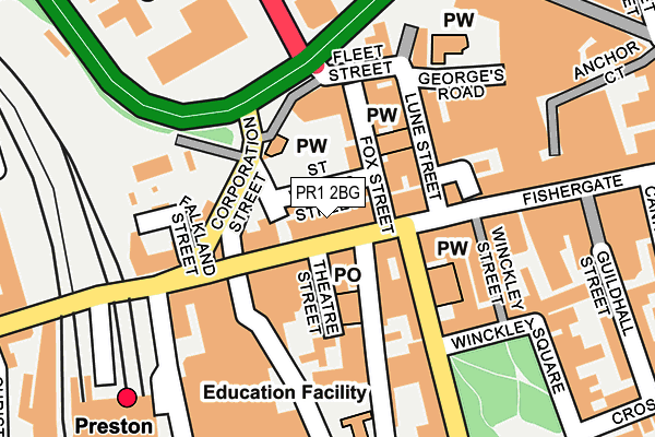
PR1 2BG is located in the City Centre electoral ward, within the local authority district of Preston and the English Parliamentary constituency of Preston. The Sub Integrated Care Board (ICB) Location is NHS Lancashire and South Cumbria ICB - 01E and the police force is Lancashire. This postcode has been in use since July 2017.


GetTheData
Source: OS OpenMap – Local (Ordnance Survey)
Source: OS VectorMap District (Ordnance Survey)
Licence: Open Government Licence (requires attribution)
| Easting | 353664 |
| Northing | 429281 |
| Latitude | 53.757831 |
| Longitude | -2.704273 |
GetTheData
Source: Open Postcode Geo
Licence: Open Government Licence
| Country | England |
| Postcode District | PR1 |
| ➜ PR1 open data dashboard ➜ See where PR1 is on a map ➜ Where is Preston? | |
GetTheData
Source: Land Registry Price Paid Data
Licence: Open Government Licence
| Ward | City Centre |
| Constituency | Preston |
GetTheData
Source: ONS Postcode Database
Licence: Open Government Licence
| January 2024 | Anti-social behaviour | On or near Nightclub | 484m |
| January 2024 | Anti-social behaviour | On or near Nightclub | 484m |
| January 2024 | Anti-social behaviour | On or near Nightclub | 484m |
| ➜ Get more crime data in our Crime section | |||
GetTheData
Source: data.police.uk
Licence: Open Government Licence
| St Georges Centre (Lune Street) | Preston City Centre | 112m |
| Railway Station (Fishergate Hill) | Preston City Centre | 187m |
| Railway Station (Fishergate Hill) | Preston City Centre | 212m |
| Railway Station (Fishergate) | Preston City Centre | 252m |
| Rail Station (Butler Street) | Preston City Centre | 265m |
| Preston Station | 0.3km |
| Lostock Hall Station | 3.9km |
| Bamber Bridge Station | 4.5km |
GetTheData
Source: NaPTAN
Licence: Open Government Licence
| Percentage of properties with Next Generation Access | 100.0% |
| Percentage of properties with Superfast Broadband | 100.0% |
| Percentage of properties with Ultrafast Broadband | 0.0% |
| Percentage of properties with Full Fibre Broadband | 0.0% |
Superfast Broadband is between 30Mbps and 300Mbps
Ultrafast Broadband is > 300Mbps
| Percentage of properties unable to receive 2Mbps | 0.0% |
| Percentage of properties unable to receive 5Mbps | 0.0% |
| Percentage of properties unable to receive 10Mbps | 0.0% |
| Percentage of properties unable to receive 30Mbps | 0.0% |
GetTheData
Source: Ofcom
Licence: Ofcom Terms of Use (requires attribution)
GetTheData
Source: ONS Postcode Database
Licence: Open Government Licence


➜ Get more ratings from the Food Standards Agency
GetTheData
Source: Food Standards Agency
Licence: FSA terms & conditions
| Last Collection | |||
|---|---|---|---|
| Location | Mon-Fri | Sat | Distance |
| Preston Post Office | 18:30 | 12:30 | 83m |
| Preston Post Office | 18:30 | 12:30 | 95m |
| Chapel Street | 18:00 | 11:30 | 106m |
GetTheData
Source: Dracos
Licence: Creative Commons Attribution-ShareAlike
| Facility | Distance |
|---|---|
| Reviva Health Club For Women (Preston) (Closed) Hill Street, Preston Studio, Health and Fitness Gym | 253m |
| Bodyshapers (Closed) Corporation Street, Preston Health and Fitness Gym | 314m |
| Jd Gyms (Preston) (Closed) Market Street, Preston Health and Fitness Gym, Studio | 401m |
GetTheData
Source: Active Places
Licence: Open Government Licence
| School | Phase of Education | Distance |
|---|---|---|
| Imam Muhammad Zakariya School 2 Bairstow Street, Preston, PR1 3TN | Not applicable | 364m |
| University of Central Lancashire Adelphi Building, Preston, PR1 2HE | Not applicable | 442m |
| Stoneygate Nursery School Stoneygate Walk, Preston, PR1 3XU | Nursery | 555m |
GetTheData
Source: Edubase
Licence: Open Government Licence
The below table lists the International Territorial Level (ITL) codes (formerly Nomenclature of Territorial Units for Statistics (NUTS) codes) and Local Administrative Units (LAU) codes for PR1 2BG:
| ITL 1 Code | Name |
|---|---|
| TLD | North West (England) |
| ITL 2 Code | Name |
| TLD4 | Lancashire |
| ITL 3 Code | Name |
| TLD45 | Mid Lancashire |
| LAU 1 Code | Name |
| E07000123 | Preston |
GetTheData
Source: ONS Postcode Directory
Licence: Open Government Licence
The below table lists the Census Output Area (OA), Lower Layer Super Output Area (LSOA), and Middle Layer Super Output Area (MSOA) for PR1 2BG:
| Code | Name | |
|---|---|---|
| OA | E00128434 | |
| LSOA | E01025306 | Preston 017D |
| MSOA | E02005269 | Preston 017 |
GetTheData
Source: ONS Postcode Directory
Licence: Open Government Licence
| PR1 2US | St Wilfrid Street | 21m |
| PR1 2NJ | Fishergate | 29m |
| PR1 8BH | Fishergate | 44m |
| PR1 2AB | Fox Street | 91m |
| PR1 2NL | Lune Street | 91m |
| PR1 8BQ | Theatre Street | 95m |
| PR1 8AY | Chapel Street | 97m |
| PR1 2UP | Corporation Street | 112m |
| PR1 2AD | Fishergate | 128m |
| PR1 8BU | Chapel Street | 133m |
GetTheData
Source: Open Postcode Geo; Land Registry Price Paid Data
Licence: Open Government Licence