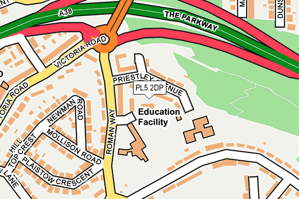
PL5 2DP is located in the Honicknowle electoral ward, within the unitary authority of Plymouth and the English Parliamentary constituency of Plymouth, Moor View. The Sub Integrated Care Board (ICB) Location is NHS Devon ICB - 15N and the police force is Devon & Cornwall. This postcode has been in use since May 2017.


GetTheData
Source: OS OpenMap – Local (Ordnance Survey)
Source: OS VectorMap District (Ordnance Survey)
Licence: Open Government Licence (requires attribution)
| Easting | 246415 |
| Northing | 58953 |
| Latitude | 50.410307 |
| Longitude | -4.162903 |
GetTheData
Source: Open Postcode Geo
Licence: Open Government Licence
| Country | England |
| Postcode District | PL5 |
| ➜ PL5 open data dashboard ➜ See where PL5 is on a map ➜ Where is Plymouth? | |
GetTheData
Source: Land Registry Price Paid Data
Licence: Open Government Licence
| Ward | Honicknowle |
| Constituency | Plymouth, Moor View |
GetTheData
Source: ONS Postcode Database
Licence: Open Government Licence
32, LILFORD GARDENS, PLYMOUTH, PL5 2DP 2023 15 DEC £331,000 |
34, LILFORD GARDENS, PLYMOUTH, PL5 2DP 2023 8 SEP £367,500 |
2023 25 APR £400,000 |
CARAVAN, 7, LILFORD GARDENS, PLYMOUTH, PL5 2DP 2023 31 MAR £380,000 |
2022 1 DEC £400,000 |
36, LILFORD GARDENS, PLYMOUTH, PL5 2DP 2022 9 SEP £350,000 |
GetTheData
Source: HM Land Registry Price Paid Data
Licence: Contains HM Land Registry data © Crown copyright and database right 2024. This data is licensed under the Open Government Licence v3.0.
| October 2022 | Violence and sexual offences | On or near Little Dock Lane | 149m |
| October 2022 | Criminal damage and arson | On or near Little Dock Lane | 149m |
| August 2022 | Public order | On or near Montacute Avenue | 212m |
| ➜ Get more crime data in our Crime section | |||
GetTheData
Source: data.police.uk
Licence: Open Government Licence
| Coombe Park Lane Green (Coombe Park Lane) | Honicknowle | 91m |
| Coombe Park Lane East (Coombe Park Lane) | Honicknowle | 103m |
| Coombe Park Lane Green (Coombe Park Lane) | Honicknowle | 119m |
| Community Centre (Honicknowle Green) | Honicknowle | 217m |
| Ashburnham Road (Little Dock Lane) | Honicknowle | 231m |
| St Budeaux Ferry Road Station | 2km |
| St Budeaux Victoria Road Station | 2km |
| Keyham Station | 2.6km |
GetTheData
Source: NaPTAN
Licence: Open Government Licence
| Percentage of properties with Next Generation Access | 100.0% |
| Percentage of properties with Superfast Broadband | 100.0% |
| Percentage of properties with Ultrafast Broadband | 0.0% |
| Percentage of properties with Full Fibre Broadband | 0.0% |
Superfast Broadband is between 30Mbps and 300Mbps
Ultrafast Broadband is > 300Mbps
| Percentage of properties unable to receive 2Mbps | 0.0% |
| Percentage of properties unable to receive 5Mbps | 0.0% |
| Percentage of properties unable to receive 10Mbps | 0.0% |
| Percentage of properties unable to receive 30Mbps | 0.0% |
GetTheData
Source: Ofcom
Licence: Ofcom Terms of Use (requires attribution)
GetTheData
Source: ONS Postcode Database
Licence: Open Government Licence


➜ Get more ratings from the Food Standards Agency
GetTheData
Source: Food Standards Agency
Licence: FSA terms & conditions
| Last Collection | |||
|---|---|---|---|
| Location | Mon-Fri | Sat | Distance |
| Lakeside Drive | 17:00 | 12:00 | 1,120m |
| Cardinal Avenue | 17:30 | 12:00 | 1,725m |
| Victoria Road | 17:30 | 12:30 | 1,816m |
GetTheData
Source: Dracos
Licence: Creative Commons Attribution-ShareAlike
| Facility | Distance |
|---|---|
| Knowle Battery Instow Walk, Plymouth Grass Pitches | 529m |
| Shakespeare Primary School Honicknowle Lane, Plymouth Grass Pitches | 549m |
| West Park Playing Field Wollaton Grove, Plymouth Grass Pitches | 580m |
GetTheData
Source: Active Places
Licence: Open Government Licence
| School | Phase of Education | Distance |
|---|---|---|
| Shakespeare Primary School 400 Honicknowle Lane, Honicknowle, Plymouth, PL5 3JU | Primary | 494m |
| Knowle Primary School Ringmore Way, West Park, Plymouth, PL5 3QG | Primary | 663m |
| Brook Green Centre for Learning Bodmin Road, Whitleigh, Plymouth, PL5 4DZ | Not applicable | 922m |
GetTheData
Source: Edubase
Licence: Open Government Licence
The below table lists the International Territorial Level (ITL) codes (formerly Nomenclature of Territorial Units for Statistics (NUTS) codes) and Local Administrative Units (LAU) codes for PL5 2DP:
| ITL 1 Code | Name |
|---|---|
| TLK | South West (England) |
| ITL 2 Code | Name |
| TLK4 | Devon |
| ITL 3 Code | Name |
| TLK41 | Plymouth |
| LAU 1 Code | Name |
| E06000026 | Plymouth |
GetTheData
Source: ONS Postcode Directory
Licence: Open Government Licence
The below table lists the Census Output Area (OA), Lower Layer Super Output Area (LSOA), and Middle Layer Super Output Area (MSOA) for PL5 2DP:
| Code | Name | |
|---|---|---|
| OA | E00076193 | |
| LSOA | E01015087 | Plymouth 006B |
| MSOA | E02003127 | Plymouth 006 |
GetTheData
Source: ONS Postcode Directory
Licence: Open Government Licence
| PL5 2LY | Wanstead Grove | 67m |
| PL5 2LU | Coombe Park Lane | 107m |
| PL5 2LZ | Little Dock Lane | 117m |
| PL5 2ND | Eastbury Avenue | 124m |
| PL5 2LB | St Francis Court | 138m |
| PL5 2NA | Little Dock Lane | 149m |
| PL5 2LT | Coombe Park Lane | 156m |
| PL5 3PZ | Ashridge Gardens | 158m |
| PL5 2LX | Wanstead Grove | 160m |
| PL5 3PW | Montacute Avenue | 181m |
GetTheData
Source: Open Postcode Geo; Land Registry Price Paid Data
Licence: Open Government Licence