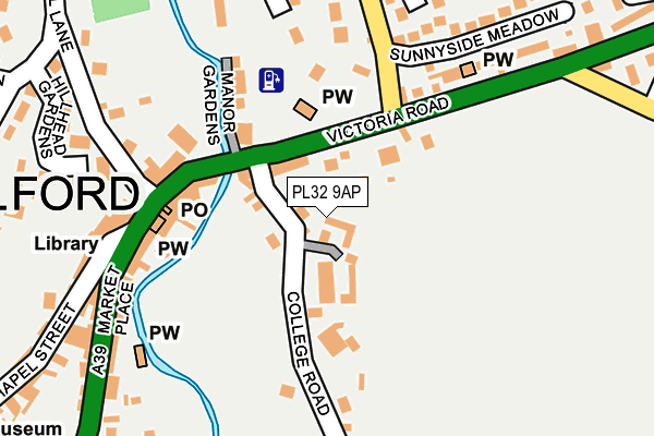
PL32 9AP is located in the Camelford & Boscastle electoral ward, within the unitary authority of Cornwall and the English Parliamentary constituency of North Cornwall. The Sub Integrated Care Board (ICB) Location is NHS Cornwall and the Isles of Scilly ICB - 11N and the police force is Devon & Cornwall. This postcode has been in use since June 2017.


GetTheData
Source: OS OpenMap – Local (Ordnance Survey)
Source: OS VectorMap District (Ordnance Survey)
Licence: Open Government Licence (requires attribution)
| Easting | 210764 |
| Northing | 83709 |
| Latitude | 50.622295 |
| Longitude | -4.676686 |
GetTheData
Source: Open Postcode Geo
Licence: Open Government Licence
| Country | England |
| Postcode District | PL32 |
➜ See where PL32 is on a map ➜ Where is Camelford? | |
GetTheData
Source: Land Registry Price Paid Data
Licence: Open Government Licence
| Ward | Camelford & Boscastle |
| Constituency | North Cornwall |
GetTheData
Source: ONS Postcode Database
Licence: Open Government Licence
2022 1 DEC £500,000 |
2020 23 OCT £400,000 |
2020 23 MAR £375,000 |
1, THE OLD GRAMMAR SCHOOL, COLLEGE ROAD, CAMELFORD, PL32 9AP 2020 14 JAN £407,500 |
5, THE OLD GRAMMAR SCHOOL, COLLEGE ROAD, CAMELFORD, PL32 9AP 2019 6 JUN £420,000 |
4, THE OLD GRAMMAR SCHOOL, COLLEGE ROAD, CAMELFORD, PL32 9AP 2018 7 AUG £399,000 |
2017 3 OCT £405,000 |
2, THE OLD GRAMMAR SCHOOL, COLLEGE ROAD, CAMELFORD, PL32 9AP 2017 18 AUG £420,000 |
GetTheData
Source: HM Land Registry Price Paid Data
Licence: Contains HM Land Registry data © Crown copyright and database right 2025. This data is licensed under the Open Government Licence v3.0.
| Camelford Church (Victoria Road) | Camelford | 130m |
| Post Office (Market Place) | Camelford | 166m |
| Museum (Clease Road) | Camelford | 389m |
| Museum (Clease Road) | Camelford | 389m |
| Bus Park Sir James Smith Sch | Camelford | 653m |
GetTheData
Source: NaPTAN
Licence: Open Government Licence
GetTheData
Source: ONS Postcode Database
Licence: Open Government Licence


➜ Get more ratings from the Food Standards Agency
GetTheData
Source: Food Standards Agency
Licence: FSA terms & conditions
| Last Collection | |||
|---|---|---|---|
| Location | Mon-Fri | Sat | Distance |
| Lanteglos | 09:00 | 11:30 | 2,359m |
| Highertown | 09:30 | 10:00 | 2,825m |
| Victoria | 16:00 | 09:45 | 4,116m |
GetTheData
Source: Dracos
Licence: Creative Commons Attribution-ShareAlike
The below table lists the International Territorial Level (ITL) codes (formerly Nomenclature of Territorial Units for Statistics (NUTS) codes) and Local Administrative Units (LAU) codes for PL32 9AP:
| ITL 1 Code | Name |
|---|---|
| TLK | South West (England) |
| ITL 2 Code | Name |
| TLK3 | Cornwall and Isles of Scilly |
| ITL 3 Code | Name |
| TLK30 | Cornwall and Isles of Scilly |
| LAU 1 Code | Name |
| E06000052 | Cornwall |
GetTheData
Source: ONS Postcode Directory
Licence: Open Government Licence
The below table lists the Census Output Area (OA), Lower Layer Super Output Area (LSOA), and Middle Layer Super Output Area (MSOA) for PL32 9AP:
| Code | Name | |
|---|---|---|
| OA | E00095640 | |
| LSOA | E01033291 | Cornwall 004D |
| MSOA | E02003934 | Cornwall 004 |
GetTheData
Source: ONS Postcode Directory
Licence: Open Government Licence
| PL32 9TL | College Road | 107m |
| PL32 9TH | Victoria Road | 113m |
| PL32 9PD | Market Place | 173m |
| PL32 9PB | Market Place | 177m |
| PL32 9TB | Manor Gardens | 214m |
| PL32 9PE | Mill Lane | 215m |
| PL32 9PG | Fore Street | 233m |
| PL32 9SD | Anvil Road | 246m |
| PL32 9TN | Sunnyside Meadows | 269m |
| PL32 9XA | Victoria Road | 271m |
GetTheData
Source: Open Postcode Geo; Land Registry Price Paid Data
Licence: Open Government Licence