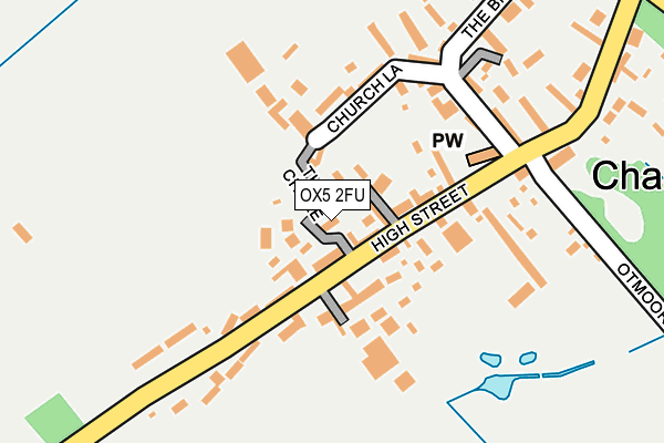
OX5 2FU is located in the Launton and Otmoor electoral ward, within the local authority district of Cherwell and the English Parliamentary constituency of Henley. The Sub Integrated Care Board (ICB) Location is NHS Buckinghamshire, Oxfordshire and Berkshire West ICB - 10Q and the police force is Thames Valley. This postcode has been in use since April 2017.


GetTheData
Source: OS OpenMap – Local (Ordnance Survey)
Source: OS VectorMap District (Ordnance Survey)
Licence: Open Government Licence (requires attribution)
| Easting | 456053 |
| Northing | 215761 |
| Latitude | 51.837659 |
| Longitude | -1.187845 |
GetTheData
Source: Open Postcode Geo
Licence: Open Government Licence
| Country | England |
| Postcode District | OX5 |
| ➜ OX5 open data dashboard ➜ See where OX5 is on a map ➜ Where is Charlton-on-Otmoor? | |
GetTheData
Source: Land Registry Price Paid Data
Licence: Open Government Licence
| Ward | Launton And Otmoor |
| Constituency | Henley |
GetTheData
Source: ONS Postcode Database
Licence: Open Government Licence
| May 2022 | Violence and sexual offences | On or near The Chure | 23m |
| May 2022 | Violence and sexual offences | On or near The Chure | 23m |
| March 2022 | Possession of weapons | On or near Church View | 361m |
| ➜ Get more crime data in our Crime section | |||
GetTheData
Source: data.police.uk
Licence: Open Government Licence
| Bus Garage (High Street) | Charlton-on-otmoor | 83m |
| Bus Garage (High Street) | Charlton-on-otmoor | 89m |
| Church View | Charlton-on-otmoor | 361m |
| Church View | Charlton-on-otmoor | 365m |
| Glebe Barn Bus Shelter (High Street) | Oddington | 1,034m |
| Islip Station | 3.7km |
GetTheData
Source: NaPTAN
Licence: Open Government Licence
| Percentage of properties with Next Generation Access | 100.0% |
| Percentage of properties with Superfast Broadband | 100.0% |
| Percentage of properties with Ultrafast Broadband | 0.0% |
| Percentage of properties with Full Fibre Broadband | 0.0% |
Superfast Broadband is between 30Mbps and 300Mbps
Ultrafast Broadband is > 300Mbps
| Percentage of properties unable to receive 2Mbps | 0.0% |
| Percentage of properties unable to receive 5Mbps | 0.0% |
| Percentage of properties unable to receive 10Mbps | 0.0% |
| Percentage of properties unable to receive 30Mbps | 0.0% |
GetTheData
Source: Ofcom
Licence: Ofcom Terms of Use (requires attribution)
GetTheData
Source: ONS Postcode Database
Licence: Open Government Licence

➜ Get more ratings from the Food Standards Agency
GetTheData
Source: Food Standards Agency
Licence: FSA terms & conditions
| Last Collection | |||
|---|---|---|---|
| Location | Mon-Fri | Sat | Distance |
| High Street | 15:45 | 09:15 | 50m |
| Mill Lane | 15:45 | 09:15 | 370m |
| College Farm | 15:45 | 09:30 | 1,147m |
GetTheData
Source: Dracos
Licence: Creative Commons Attribution-ShareAlike
| Facility | Distance |
|---|---|
| Charlton On Otmoor Playing Fields Ray View, Charlton On Otmoor, Kidlington Grass Pitches | 272m |
| Merton Village Playing Fields Otmoor View, Merton, Bicester Grass Pitches | 2.3km |
| Islip - Church Lane/The Rise Church Lane, Islip, Kidlington Grass Pitches | 3.9km |
GetTheData
Source: Active Places
Licence: Open Government Licence
| School | Phase of Education | Distance |
|---|---|---|
| Charlton-on-Otmoor Church of England Primary School Fencott Road, Charlton-on-Otmoor, Kidlington, OX5 2UT | Primary | 398m |
| Dr South's Church of England Primary School Bletchingdon Road, Islip, Kidlington, OX5 2TQ | Primary | 3.8km |
| Beckley Church of England Primary School Church Street, Beckley, Oxford, OX3 9UT | Primary | 4.4km |
GetTheData
Source: Edubase
Licence: Open Government Licence
The below table lists the International Territorial Level (ITL) codes (formerly Nomenclature of Territorial Units for Statistics (NUTS) codes) and Local Administrative Units (LAU) codes for OX5 2FU:
| ITL 1 Code | Name |
|---|---|
| TLJ | South East (England) |
| ITL 2 Code | Name |
| TLJ1 | Berkshire, Buckinghamshire and Oxfordshire |
| ITL 3 Code | Name |
| TLJ14 | Oxfordshire CC |
| LAU 1 Code | Name |
| E07000177 | Cherwell |
GetTheData
Source: ONS Postcode Directory
Licence: Open Government Licence
The below table lists the Census Output Area (OA), Lower Layer Super Output Area (LSOA), and Middle Layer Super Output Area (MSOA) for OX5 2FU:
| Code | Name | |
|---|---|---|
| OA | E00145209 | |
| LSOA | E01028502 | Cherwell 016F |
| MSOA | E02005936 | Cherwell 016 |
GetTheData
Source: ONS Postcode Directory
Licence: Open Government Licence
| OX5 2UJ | The Tchure | 28m |
| OX5 2UH | Blacksmith Lane | 44m |
| OX5 2UQ | High Street | 70m |
| OX5 2TZ | 119m | |
| OX5 2UL | Ray View | 178m |
| OX5 2UA | Church Lane | 184m |
| OX5 2UG | High Street | 265m |
| OX5 2UB | The Broadway | 275m |
| OX5 2UT | Fencott Road | 368m |
| OX5 2UF | Church View | 383m |
GetTheData
Source: Open Postcode Geo; Land Registry Price Paid Data
Licence: Open Government Licence