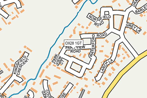
OX28 1GT is located in the Witney East electoral ward, within the local authority district of West Oxfordshire and the English Parliamentary constituency of Witney. The Sub Integrated Care Board (ICB) Location is NHS Buckinghamshire, Oxfordshire and Berkshire West ICB - 10Q and the police force is Thames Valley. This postcode has been in use since May 2017.


GetTheData
Source: OS OpenMap – Local (Ordnance Survey)
Source: OS VectorMap District (Ordnance Survey)
Licence: Open Government Licence (requires attribution)
| Easting | 436719 |
| Northing | 210164 |
| Latitude | 51.788939 |
| Longitude | -1.469032 |
GetTheData
Source: Open Postcode Geo
Licence: Open Government Licence
| Country | England |
| Postcode District | OX28 |
| ➜ OX28 open data dashboard ➜ See where OX28 is on a map | |
GetTheData
Source: Land Registry Price Paid Data
Licence: Open Government Licence
| Ward | Witney East |
| Constituency | Witney |
GetTheData
Source: ONS Postcode Database
Licence: Open Government Licence
| January 2024 | Violence and sexual offences | On or near Courts Gardens | 204m |
| October 2023 | Violence and sexual offences | On or near Wadard'S Meadow | 487m |
| September 2023 | Violence and sexual offences | On or near Wadard'S Meadow | 487m |
| ➜ Get more crime data in our Crime section | |||
GetTheData
Source: data.police.uk
Licence: Open Government Licence
| Church Lane (Newland) | Witney | 332m |
| Cogges Hill Road (Oxford Hill) | Witney | 342m |
| Church Lane (Newland) | Witney | 347m |
| King Georges Field (Newland) | Witney | 392m |
| King Georges Field (Newland) | Witney | 415m |
GetTheData
Source: NaPTAN
Licence: Open Government Licence
GetTheData
Source: ONS Postcode Database
Licence: Open Government Licence


➜ Get more ratings from the Food Standards Agency
GetTheData
Source: Food Standards Agency
Licence: FSA terms & conditions
| Last Collection | |||
|---|---|---|---|
| Location | Mon-Fri | Sat | Distance |
| Madley Park | 16:45 | 09:00 | 502m |
| Newlands Post Office | 16:45 | 11:30 | 512m |
| Woodstock Road | 16:45 | 07:30 | 643m |
GetTheData
Source: Dracos
Licence: Creative Commons Attribution-ShareAlike
| Facility | Distance |
|---|---|
| King George V Playing Field (Witney) Newland, Witney Grass Pitches | 409m |
| Wood Green School Woodstock Road, Witney Health and Fitness Gym, Sports Hall, Artificial Grass Pitch, Swimming Pool, Grass Pitches, Outdoor Tennis Courts | 412m |
| Witney Mills Cricket Club Newland, Witney Grass Pitches | 676m |
GetTheData
Source: Active Places
Licence: Open Government Licence
| School | Phase of Education | Distance |
|---|---|---|
| Wood Green School Woodstock Road, Witney, OX28 1DX | Secondary | 412m |
| Springfield School At the Bronze Barrow, Cedar Drive, Cedar Drive, Madley Park, WITNEY, OX28 1AR | Not applicable | 413m |
| Madley Brook Community Primary School At the Bronze Barrow, Cedar Drive, Witney, OX28 1AR | Primary | 413m |
GetTheData
Source: Edubase
Licence: Open Government Licence
The below table lists the International Territorial Level (ITL) codes (formerly Nomenclature of Territorial Units for Statistics (NUTS) codes) and Local Administrative Units (LAU) codes for OX28 1GT:
| ITL 1 Code | Name |
|---|---|
| TLJ | South East (England) |
| ITL 2 Code | Name |
| TLJ1 | Berkshire, Buckinghamshire and Oxfordshire |
| ITL 3 Code | Name |
| TLJ14 | Oxfordshire CC |
| LAU 1 Code | Name |
| E07000181 | West Oxfordshire |
GetTheData
Source: ONS Postcode Directory
Licence: Open Government Licence
The below table lists the Census Output Area (OA), Lower Layer Super Output Area (LSOA), and Middle Layer Super Output Area (MSOA) for OX28 1GT:
| Code | Name | |
|---|---|---|
| OA | E00169067 | |
| LSOA | E01032947 | West Oxfordshire 008G |
| MSOA | E02006000 | West Oxfordshire 008 |
GetTheData
Source: ONS Postcode Directory
Licence: Open Government Licence
| OX28 1GA | Park View Road | 0m |
| OX28 1FZ | Park View Lane | 46m |
| OX28 1FF | Waterford Road | 70m |
| OX28 1GB | Waterford Lane | 97m |
| OX28 1GL | Park View Court | 99m |
| OX28 1GD | Waterford Road | 101m |
| OX28 1AG | Larch Lane | 156m |
| OX28 1FY | Northfield Road | 171m |
| OX28 2GX | Court Gardens | 177m |
| OX28 2JY | Judds Close | 199m |
GetTheData
Source: Open Postcode Geo; Land Registry Price Paid Data
Licence: Open Government Licence