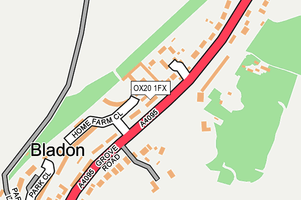
OX20 1FX is located in the Woodstock and Bladon electoral ward, within the local authority district of West Oxfordshire and the English Parliamentary constituency of Witney. The Sub Integrated Care Board (ICB) Location is NHS Buckinghamshire, Oxfordshire and Berkshire West ICB - 10Q and the police force is Thames Valley. This postcode has been in use since May 2017.


GetTheData
Source: OS OpenMap – Local (Ordnance Survey)
Source: OS VectorMap District (Ordnance Survey)
Licence: Open Government Licence (requires attribution)
| Easting | 445038 |
| Northing | 215231 |
| Latitude | 51.833888 |
| Longitude | -1.347772 |
GetTheData
Source: Open Postcode Geo
Licence: Open Government Licence
| Country | England |
| Postcode District | OX20 |
| ➜ OX20 open data dashboard ➜ See where OX20 is on a map ➜ Where is Bladon? | |
GetTheData
Source: Land Registry Price Paid Data
Licence: Open Government Licence
| Ward | Woodstock And Bladon |
| Constituency | Witney |
GetTheData
Source: ONS Postcode Database
Licence: Open Government Licence
| June 2022 | Violence and sexual offences | On or near The Homestead | 85m |
| April 2022 | Burglary | On or near Park Close | 296m |
| April 2022 | Criminal damage and arson | On or near Park Close | 296m |
| ➜ Get more crime data in our Crime section | |||
GetTheData
Source: data.police.uk
Licence: Open Government Licence
| The Homestead (Grove Road) | Bladon | 139m |
| The Homestead (Grove Road) | Bladon | 160m |
| Church (Grove Road) | Bladon | 221m |
| Church (Grove Road) | Bladon | 250m |
| Lamb Lane (Park Street) | Bladon | 605m |
| Hanborough Station | 2km |
| Combe (Oxon) Station | 3.2km |
GetTheData
Source: NaPTAN
Licence: Open Government Licence
➜ Broadband speed and availability dashboard for OX20 1FX
| Percentage of properties with Next Generation Access | 100.0% |
| Percentage of properties with Superfast Broadband | 100.0% |
| Percentage of properties with Ultrafast Broadband | 0.0% |
| Percentage of properties with Full Fibre Broadband | 0.0% |
Superfast Broadband is between 30Mbps and 300Mbps
Ultrafast Broadband is > 300Mbps
| Median download speed | 40.0Mbps |
| Average download speed | 39.2Mbps |
| Maximum download speed | 76.85Mbps |
| Median upload speed | 10.0Mbps |
| Average upload speed | 9.7Mbps |
| Maximum upload speed | 18.92Mbps |
| Percentage of properties unable to receive 2Mbps | 0.0% |
| Percentage of properties unable to receive 5Mbps | 0.0% |
| Percentage of properties unable to receive 10Mbps | 0.0% |
| Percentage of properties unable to receive 30Mbps | 0.0% |
➜ Broadband speed and availability dashboard for OX20 1FX
GetTheData
Source: Ofcom
Licence: Ofcom Terms of Use (requires attribution)
GetTheData
Source: ONS Postcode Database
Licence: Open Government Licence


➜ Get more ratings from the Food Standards Agency
GetTheData
Source: Food Standards Agency
Licence: FSA terms & conditions
| Last Collection | |||
|---|---|---|---|
| Location | Mon-Fri | Sat | Distance |
| Grove Road | 16:30 | 08:30 | 135m |
| Bladon Post Office | 16:30 | 07:30 | 348m |
| Heath Lane | 16:30 | 07:15 | 617m |
GetTheData
Source: Dracos
Licence: Creative Commons Attribution-ShareAlike
| Facility | Distance |
|---|---|
| Woodstock Bowls & Tennis Club Cadogan Park, Woodstock Outdoor Tennis Courts | 1.5km |
| Woodstock Town Fc New Road, Woodstock Grass Pitches | 1.5km |
| Woodstock C Of E Primary School Shipton Road, Woodstock Grass Pitches | 1.6km |
GetTheData
Source: Active Places
Licence: Open Government Licence
| School | Phase of Education | Distance |
|---|---|---|
| Bladon Church of England Primary School Park Street, Bladon, Woodstock, OX20 1RW | Primary | 543m |
| Woodstock Church of England Primary School Shipton Road, Woodstock, OX20 1LL | Primary | 1.6km |
| The Marlborough Church of England School Shipton Road, Woodstock, OX20 1LP | Secondary | 1.7km |
GetTheData
Source: Edubase
Licence: Open Government Licence
The below table lists the International Territorial Level (ITL) codes (formerly Nomenclature of Territorial Units for Statistics (NUTS) codes) and Local Administrative Units (LAU) codes for OX20 1FX:
| ITL 1 Code | Name |
|---|---|
| TLJ | South East (England) |
| ITL 2 Code | Name |
| TLJ1 | Berkshire, Buckinghamshire and Oxfordshire |
| ITL 3 Code | Name |
| TLJ14 | Oxfordshire CC |
| LAU 1 Code | Name |
| E07000181 | West Oxfordshire |
GetTheData
Source: ONS Postcode Directory
Licence: Open Government Licence
The below table lists the Census Output Area (OA), Lower Layer Super Output Area (LSOA), and Middle Layer Super Output Area (MSOA) for OX20 1FX:
| Code | Name | |
|---|---|---|
| OA | E00146796 | |
| LSOA | E01028825 | West Oxfordshire 004F |
| MSOA | E02005996 | West Oxfordshire 004 |
GetTheData
Source: ONS Postcode Directory
Licence: Open Government Licence
| OX20 1XA | The Homestead | 73m |
| OX20 1RG | Grove Road | 178m |
| OX20 1RD | Grove Road | 201m |
| OX20 1RN | Park Close | 256m |
| OX20 1RJ | Grove Road | 272m |
| OX20 1RQ | Grove Road | 285m |
| OX20 1SE | Lincoln Grove | 302m |
| OX20 1RA | Grove Road | 328m |
| OX20 1RL | Park Lane | 366m |
| OX20 1RW | Park Street | 488m |
GetTheData
Source: Open Postcode Geo; Land Registry Price Paid Data
Licence: Open Government Licence