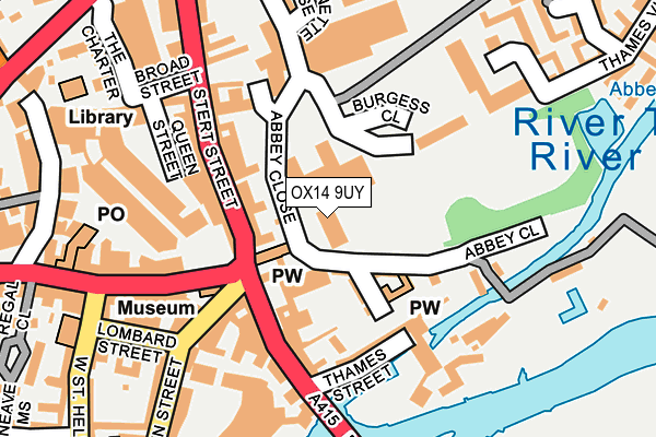
OX14 9UY is located in the Abingdon Abbey Northcourt electoral ward, within the local authority district of Vale of White Horse and the English Parliamentary constituency of Oxford West and Abingdon. The Sub Integrated Care Board (ICB) Location is NHS Buckinghamshire, Oxfordshire and Berkshire West ICB - 10Q and the police force is Thames Valley. This postcode has been in use since February 2017.


GetTheData
Source: OS OpenMap – Local (Ordnance Survey)
Source: OS VectorMap District (Ordnance Survey)
Licence: Open Government Licence (requires attribution)
| Easting | 449895 |
| Northing | 197114 |
| Latitude | 51.670595 |
| Longitude | -1.279885 |
GetTheData
Source: Open Postcode Geo
Licence: Open Government Licence
| Country | England |
| Postcode District | OX14 |
| ➜ OX14 open data dashboard ➜ See where OX14 is on a map | |
GetTheData
Source: Land Registry Price Paid Data
Licence: Open Government Licence
| Ward | Abingdon Abbey Northcourt |
| Constituency | Oxford West And Abingdon |
GetTheData
Source: ONS Postcode Database
Licence: Open Government Licence
| January 2024 | Drugs | On or near Shopping Area | 127m |
| January 2024 | Violence and sexual offences | On or near Shopping Area | 127m |
| January 2024 | Violence and sexual offences | On or near Shopping Area | 127m |
| ➜ Get more crime data in our Crime section | |||
GetTheData
Source: data.police.uk
Licence: Open Government Licence
| Bridge Street | Abingdon Town Centre | 127m |
| High Street | Abingdon Town Centre | 170m |
| Stert Street | Abingdon Town Centre | 227m |
| West St Helen Street | Abingdon Town Centre | 237m |
| War Memorial (High Street) | Abingdon Town Centre | 285m |
| Radley Station | 3.2km |
| Culham Station | 3.5km |
| Appleford Station | 4.3km |
GetTheData
Source: NaPTAN
Licence: Open Government Licence
GetTheData
Source: ONS Postcode Database
Licence: Open Government Licence


➜ Get more ratings from the Food Standards Agency
GetTheData
Source: Food Standards Agency
Licence: FSA terms & conditions
| Last Collection | |||
|---|---|---|---|
| Location | Mon-Fri | Sat | Distance |
| Market Place | 17:15 | 11:30 | 106m |
| Waitrose | 18:00 | 11:00 | 137m |
| Station | 17:00 | 11:30 | 204m |
GetTheData
Source: Dracos
Licence: Creative Commons Attribution-ShareAlike
| Facility | Distance |
|---|---|
| Feelgood Fitness (Abingdon) (Closed) Queen Street, Abingdon Health and Fitness Gym | 128m |
| Abbey Meadows Outdoor Pool Abbey Close, Abingdon Golf, Swimming Pool, Outdoor Tennis Courts | 239m |
| Hales & Hayes Meadow Culham Road, Abingdon Grass Pitches | 372m |
GetTheData
Source: Active Places
Licence: Open Government Licence
| School | Phase of Education | Distance |
|---|---|---|
| Abingdon School Park Road, Abingdon, OX14 1DE | Not applicable | 645m |
| Our Lady's Abingdon Radley Road, Abingdon, OX14 3PS | Not applicable | 650m |
| Carswell Community Primary School Bostock Road, Carswell Primary School, Abingdon, OX14 1DP | Primary | 728m |
GetTheData
Source: Edubase
Licence: Open Government Licence
The below table lists the International Territorial Level (ITL) codes (formerly Nomenclature of Territorial Units for Statistics (NUTS) codes) and Local Administrative Units (LAU) codes for OX14 9UY:
| ITL 1 Code | Name |
|---|---|
| TLJ | South East (England) |
| ITL 2 Code | Name |
| TLJ1 | Berkshire, Buckinghamshire and Oxfordshire |
| ITL 3 Code | Name |
| TLJ14 | Oxfordshire CC |
| LAU 1 Code | Name |
| E07000180 | Vale of White Horse |
GetTheData
Source: ONS Postcode Directory
Licence: Open Government Licence
The below table lists the Census Output Area (OA), Lower Layer Super Output Area (LSOA), and Middle Layer Super Output Area (MSOA) for OX14 9UY:
| Code | Name | |
|---|---|---|
| OA | E00173190 | |
| LSOA | E01033305 | Vale of White Horse 006G |
| MSOA | E02005983 | Vale of White Horse 006 |
GetTheData
Source: ONS Postcode Directory
Licence: Open Government Licence
| OX14 3JD | Abbey Close | 65m |
| OX14 3JB | Checker Walk | 79m |
| OX14 3JF | Stert Street | 96m |
| OX14 3HA | Market Place | 107m |
| OX14 3GQ | Abbey Close | 113m |
| OX14 3JP | Stert Street | 114m |
| OX14 3HS | Bridge Street | 115m |
| OX14 3HN | Bridge Street | 129m |
| OX14 3HZ | Thames Street | 129m |
| OX14 3JT | Burgess Close | 129m |
GetTheData
Source: Open Postcode Geo; Land Registry Price Paid Data
Licence: Open Government Licence