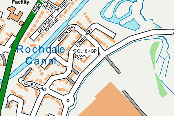
OL16 4GP is located in the Kingsway electoral ward, within the metropolitan district of Rochdale and the English Parliamentary constituency of Rochdale. The Sub Integrated Care Board (ICB) Location is NHS Greater Manchester ICB - 01D and the police force is Greater Manchester. This postcode has been in use since July 2017.


GetTheData
Source: OS OpenMap – Local (Ordnance Survey)
Source: OS VectorMap District (Ordnance Survey)
Licence: Open Government Licence (requires attribution)
| Easting | 391300 |
| Northing | 412371 |
| Latitude | 53.607838 |
| Longitude | -2.132959 |
GetTheData
Source: Open Postcode Geo
Licence: Open Government Licence
| Country | England |
| Postcode District | OL16 |
| ➜ OL16 open data dashboard ➜ See where OL16 is on a map ➜ Where is Rochdale? | |
GetTheData
Source: Land Registry Price Paid Data
Licence: Open Government Licence
| Ward | Kingsway |
| Constituency | Rochdale |
GetTheData
Source: ONS Postcode Database
Licence: Open Government Licence
| March 2022 | Other theft | On or near Wray Place | 334m |
| ➜ Get more crime data in our Crime section | |||
GetTheData
Source: data.police.uk
Licence: Open Government Licence
| Kingsway/Waithlands Rd (Kingsway) | Newbold | 273m |
| Kingsway/Kingsway Hotel (Kingsway) | Lower Place | 278m |
| Kingsway/Waithlands Rd (Kingsway) | Newbold | 305m |
| Kingsway/St. Peter's Sch (Kingsway) | Lower Place | 466m |
| Kingsway/Morrisons (Kingsway) | Firgrove | 497m |
| Newbold (Manchester Metrolink) (Kingsway) | Newbold | 639m |
| Kingsway Business Park (Manchester Metrolink) (Leyfield Road) | Milnrow | 704m |
| Milnrow (Manchester Metrolink) (Station Road) | Milnrow | 1,381m |
| Rochdale Railway Station (Manchester Metrolink) (Maclure Rd) | Rochdale | 1,465m |
| Rochdale Interchange (Manchester Metrolink) (Smith Street) | Rochdale | 1,817m |
| Rochdale Station | 1.4km |
| Smithy Bridge Station | 3.1km |
| Castleton (Manchester) Station | 3.5km |
GetTheData
Source: NaPTAN
Licence: Open Government Licence
| Percentage of properties with Next Generation Access | 100.0% |
| Percentage of properties with Superfast Broadband | 100.0% |
| Percentage of properties with Ultrafast Broadband | 100.0% |
| Percentage of properties with Full Fibre Broadband | 100.0% |
Superfast Broadband is between 30Mbps and 300Mbps
Ultrafast Broadband is > 300Mbps
| Percentage of properties unable to receive 2Mbps | 0.0% |
| Percentage of properties unable to receive 5Mbps | 0.0% |
| Percentage of properties unable to receive 10Mbps | 0.0% |
| Percentage of properties unable to receive 30Mbps | 0.0% |
GetTheData
Source: Ofcom
Licence: Ofcom Terms of Use (requires attribution)
GetTheData
Source: ONS Postcode Database
Licence: Open Government Licence


➜ Get more ratings from the Food Standards Agency
GetTheData
Source: Food Standards Agency
Licence: FSA terms & conditions
| Last Collection | |||
|---|---|---|---|
| Location | Mon-Fri | Sat | Distance |
| Kingsway | 17:00 | 11:00 | 711m |
| Lowerplace P.o. | 18:30 | 11:30 | 1,027m |
| Rochdale Delivery Office | 19:00 | 11:45 | 1,033m |
GetTheData
Source: Dracos
Licence: Creative Commons Attribution-ShareAlike
| Facility | Distance |
|---|---|
| Kingsway Park Sports Centre & Athletics Arena Turf Hill Road, Rochdale Sports Hall, Athletics, Grass Pitches, Artificial Grass Pitch | 418m |
| Lower Place Kingsway, Rochdale Grass Pitches, Artificial Grass Pitch | 762m |
| St Ann's Church Hall Milnrow Road, Rochdale Sports Hall | 1km |
GetTheData
Source: Active Places
Licence: Open Government Licence
| School | Phase of Education | Distance |
|---|---|---|
| Sacred Heart Roman Catholic Primary School Rochdale Kingsway, Rochdale, OL16 4AW | Primary | 360m |
| St Peter's Church of England Primary School Muriel Street, Rochdale, OL16 5JQ | Primary | 432m |
| Kingsway Park High School Turf Hill Road, Rochdale, OL16 4XA | Secondary | 572m |
GetTheData
Source: Edubase
Licence: Open Government Licence
The below table lists the International Territorial Level (ITL) codes (formerly Nomenclature of Territorial Units for Statistics (NUTS) codes) and Local Administrative Units (LAU) codes for OL16 4GP:
| ITL 1 Code | Name |
|---|---|
| TLD | North West (England) |
| ITL 2 Code | Name |
| TLD3 | Greater Manchester |
| ITL 3 Code | Name |
| TLD37 | Greater Manchester North East |
| LAU 1 Code | Name |
| E08000005 | Rochdale |
GetTheData
Source: ONS Postcode Directory
Licence: Open Government Licence
The below table lists the Census Output Area (OA), Lower Layer Super Output Area (LSOA), and Middle Layer Super Output Area (MSOA) for OL16 4GP:
| Code | Name | |
|---|---|---|
| OA | E00028166 | |
| LSOA | E01005563 | Rochdale 012B |
| MSOA | E02001143 | Rochdale 012 |
GetTheData
Source: ONS Postcode Directory
Licence: Open Government Licence
| OL16 4AQ | Cook Road | 95m |
| OL16 4FZ | Wedgewood Close | 160m |
| OL16 4FX | Jones Way | 232m |
| OL16 4FW | Michael Faraday Avenue | 264m |
| OL16 4AN | Deepdale Avenue | 287m |
| OL16 4FY | Wren Way | 296m |
| OL16 5EY | Kingsway | 298m |
| OL16 4AW | Kingsway | 311m |
| OL16 4AE | Burnside Road | 355m |
| OL16 4XB | Stiups Lane | 407m |
GetTheData
Source: Open Postcode Geo; Land Registry Price Paid Data
Licence: Open Government Licence