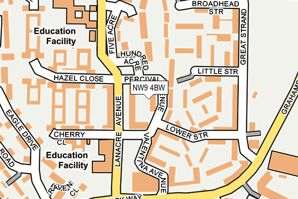
NW9 4BW is located in the Colindale North electoral ward, within the London borough of Barnet and the English Parliamentary constituency of Hendon. The Sub Integrated Care Board (ICB) Location is NHS North Central London ICB - 93C and the police force is Metropolitan Police. This postcode has been in use since June 2017.


GetTheData
Source: OS OpenMap – Local (Ordnance Survey)
Source: OS VectorMap District (Ordnance Survey)
Licence: Open Government Licence (requires attribution)
| Easting | 521678 |
| Northing | 190335 |
| Latitude | 51.598728 |
| Longitude | -0.244598 |
GetTheData
Source: Open Postcode Geo
Licence: Open Government Licence
| Country | England |
| Postcode District | NW9 |
| ➜ NW9 open data dashboard ➜ See where NW9 is on a map ➜ Where is London? | |
GetTheData
Source: Land Registry Price Paid Data
Licence: Open Government Licence
| Ward | Colindale North |
| Constituency | Hendon |
GetTheData
Source: ONS Postcode Database
Licence: Open Government Licence
| January 2024 | Anti-social behaviour | On or near Near Acre | 231m |
| January 2024 | Burglary | On or near Near Acre | 231m |
| January 2024 | Drugs | On or near Park/Open Space | 483m |
| ➜ Get more crime data in our Crime section | |||
GetTheData
Source: data.police.uk
Licence: Open Government Licence
| Cherry Close (Lanacre Avenue) | Colindale | 74m |
| Cherry Close (Lanacre Avenue) | Colindale | 151m |
| Beaufort Park (Grahame Park Way) | Colindale | 229m |
| Royal Air Force Museum (Grahame Park Way) | Colindale | 258m |
| Royal Air Force Museum (Grahame Park Way) | Colindale | 301m |
| Colindale Underground Station | Colindale | 519m |
| Burnt Oak Underground Station | Burnt Oak | 1,419m |
| Mill Hill Broadway Station | 1.6km |
| Hendon Station | 2.1km |
| Cricklewood Station | 5km |
GetTheData
Source: NaPTAN
Licence: Open Government Licence
➜ Broadband speed and availability dashboard for NW9 4BW
| Percentage of properties with Next Generation Access | 100.0% |
| Percentage of properties with Superfast Broadband | 100.0% |
| Percentage of properties with Ultrafast Broadband | 100.0% |
| Percentage of properties with Full Fibre Broadband | 100.0% |
Superfast Broadband is between 30Mbps and 300Mbps
Ultrafast Broadband is > 300Mbps
| Median download speed | 68.0Mbps |
| Average download speed | 54.4Mbps |
| Maximum download speed | 80.00Mbps |
| Median upload speed | 16.9Mbps |
| Average upload speed | 12.4Mbps |
| Maximum upload speed | 20.00Mbps |
| Percentage of properties unable to receive 2Mbps | 0.0% |
| Percentage of properties unable to receive 5Mbps | 0.0% |
| Percentage of properties unable to receive 10Mbps | 0.0% |
| Percentage of properties unable to receive 30Mbps | 0.0% |
➜ Broadband speed and availability dashboard for NW9 4BW
GetTheData
Source: Ofcom
Licence: Ofcom Terms of Use (requires attribution)
GetTheData
Source: ONS Postcode Database
Licence: Open Government Licence


➜ Get more ratings from the Food Standards Agency
GetTheData
Source: Food Standards Agency
Licence: FSA terms & conditions
| Last Collection | |||
|---|---|---|---|
| Location | Mon-Fri | Sat | Distance |
| Lanacre Avenue | 17:30 | 12:00 | 166m |
| Nw9 Great Strand | 17:30 | 12:00 | 213m |
| Booth Road | 17:30 | 12:00 | 385m |
GetTheData
Source: Dracos
Licence: Creative Commons Attribution-ShareAlike
| Facility | Distance |
|---|---|
| Saracens High School Sports Pitches Lanacre Avenue, Colindale, London Artificial Grass Pitch | 191m |
| Grahame Park Community Pitch Great Strand, London Artificial Grass Pitch | 224m |
| Grahame Park Community Centre The Concourse, Grahame Park , London Sports Hall | 303m |
GetTheData
Source: Active Places
Licence: Open Government Licence
| School | Phase of Education | Distance |
|---|---|---|
| Saracens High School Corner Mead, London, NW9 4AS | Secondary | 249m |
| St James' Catholic High School Great Strand, Colindale, London, NW9 5PE | Secondary | 344m |
| Blessed Dominic Catholic Primary School Great Strand, London, NW9 5PE | Primary | 345m |
GetTheData
Source: Edubase
Licence: Open Government Licence
The below table lists the International Territorial Level (ITL) codes (formerly Nomenclature of Territorial Units for Statistics (NUTS) codes) and Local Administrative Units (LAU) codes for NW9 4BW:
| ITL 1 Code | Name |
|---|---|
| TLI | London |
| ITL 2 Code | Name |
| TLI7 | Outer London - West and North West |
| ITL 3 Code | Name |
| TLI71 | Barnet |
| LAU 1 Code | Name |
| E09000003 | Barnet |
GetTheData
Source: ONS Postcode Directory
Licence: Open Government Licence
The below table lists the Census Output Area (OA), Lower Layer Super Output Area (LSOA), and Middle Layer Super Output Area (MSOA) for NW9 4BW:
| Code | Name | |
|---|---|---|
| OA | E00000754 | |
| LSOA | E01000154 | Barnet 026E |
| MSOA | E02000049 | Barnet 026 |
GetTheData
Source: ONS Postcode Directory
Licence: Open Government Licence
| NW9 5PB | Little Strand | 65m |
| NW9 5FG | Hundred Acre | 80m |
| NW9 5NY | Little Strand | 87m |
| NW9 5NJ | Lower Strand | 103m |
| NW9 5FT | Hazel Close | 115m |
| NW9 5PT | Little Strand | 116m |
| NW9 5NX | Little Strand | 119m |
| NW9 5GA | Hazel Close | 122m |
| NW9 5NS | Little Strand | 127m |
| NW9 5FR | Cherry Close | 128m |
GetTheData
Source: Open Postcode Geo; Land Registry Price Paid Data
Licence: Open Government Licence