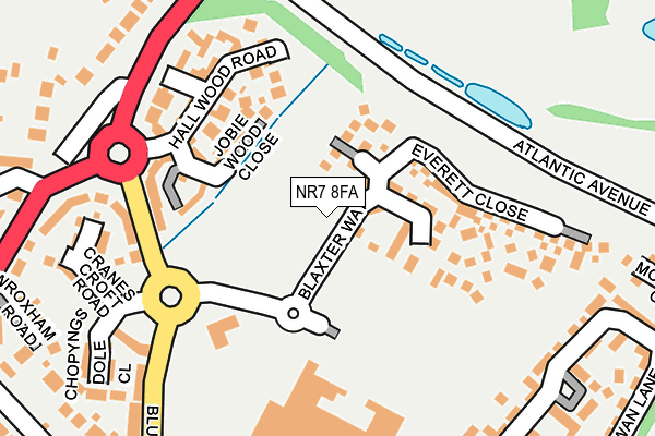
NR7 8FA is located in the Sprowston East electoral ward, within the local authority district of Broadland and the English Parliamentary constituency of Norwich North. The Sub Integrated Care Board (ICB) Location is NHS Norfolk and Waveney ICB - 26A and the police force is Norfolk. This postcode has been in use since October 2017.


GetTheData
Source: OS OpenMap – Local (Ordnance Survey)
Source: OS VectorMap District (Ordnance Survey)
Licence: Open Government Licence (requires attribution)
| Easting | 625723 |
| Northing | 312301 |
| Latitude | 52.661432 |
| Longitude | 1.336396 |
GetTheData
Source: Open Postcode Geo
Licence: Open Government Licence
| Country | England |
| Postcode District | NR7 |
| ➜ NR7 open data dashboard ➜ See where NR7 is on a map ➜ Where is Norwich? | |
GetTheData
Source: Land Registry Price Paid Data
Licence: Open Government Licence
| Ward | Sprowston East |
| Constituency | Norwich North |
GetTheData
Source: ONS Postcode Database
Licence: Open Government Licence
| October 2023 | Violence and sexual offences | On or near Chenery Drive | 407m |
| April 2023 | Anti-social behaviour | On or near Chenery Drive | 407m |
| July 2022 | Public order | On or near Chenery Drive | 407m |
| ➜ Get more crime data in our Crime section | |||
GetTheData
Source: data.police.uk
Licence: Open Government Licence
| Tesco (Blue Boar Lane) | Sprowston | 219m |
| Park And Ride (Wroxham Road) | Sprowston | 419m |
| Blue Boar (Wroxham Road) | Sprowston | 434m |
| Gage Road (Linacre Avenue) | Sprowston | 510m |
| Blue Boar (Wroxham Road) | Sprowston | 552m |
| Salhouse Station | 4km |
| Norwich Station | 4.3km |
GetTheData
Source: NaPTAN
Licence: Open Government Licence
➜ Broadband speed and availability dashboard for NR7 8FA
| Percentage of properties with Next Generation Access | 100.0% |
| Percentage of properties with Superfast Broadband | 100.0% |
| Percentage of properties with Ultrafast Broadband | 75.0% |
| Percentage of properties with Full Fibre Broadband | 75.0% |
Superfast Broadband is between 30Mbps and 300Mbps
Ultrafast Broadband is > 300Mbps
| Median download speed | 31.8Mbps |
| Average download speed | 27.6Mbps |
| Maximum download speed | 35.85Mbps |
| Median upload speed | 6.5Mbps |
| Average upload speed | 5.6Mbps |
| Maximum upload speed | 8.24Mbps |
| Percentage of properties unable to receive 2Mbps | 0.0% |
| Percentage of properties unable to receive 5Mbps | 0.0% |
| Percentage of properties unable to receive 10Mbps | 0.0% |
| Percentage of properties unable to receive 30Mbps | 0.0% |
➜ Broadband speed and availability dashboard for NR7 8FA
GetTheData
Source: Ofcom
Licence: Ofcom Terms of Use (requires attribution)
GetTheData
Source: ONS Postcode Database
Licence: Open Government Licence


➜ Get more ratings from the Food Standards Agency
GetTheData
Source: Food Standards Agency
Licence: FSA terms & conditions
| Last Collection | |||
|---|---|---|---|
| Location | Mon-Fri | Sat | Distance |
| Tesco Store | 17:30 | 11:00 | 237m |
| Church Lane Sprowston | 17:30 | 11:00 | 471m |
| Gage Road | 17:30 | 11:00 | 503m |
GetTheData
Source: Dracos
Licence: Creative Commons Attribution-ShareAlike
| Facility | Distance |
|---|---|
| White House Farm Primary School Mallard Way, Mallard Way, Sprowston, Norwich Grass Pitches | 344m |
| Sprowston Manor Hotel And Country Club Wroxham Road, Norwich Swimming Pool, Health and Fitness Gym, Golf | 461m |
| Sprowston Sports & Social Club Blue Boar Lane, Spowston, Norwich Grass Pitches | 634m |
GetTheData
Source: Active Places
Licence: Open Government Licence
| School | Phase of Education | Distance |
|---|---|---|
| White House Farm Mallard Way, Norwich, NR7 8DN | Primary | 226m |
| Sparhawk Infant School & Nursery Sparhawk Avenue, Sprowston, Norwich, NR7 8BU | Primary | 694m |
| Cecil Gowing Infant School Falcon Road West, Sprowston, Norwich, NR7 8NZ | Primary | 1.2km |
GetTheData
Source: Edubase
Licence: Open Government Licence
The below table lists the International Territorial Level (ITL) codes (formerly Nomenclature of Territorial Units for Statistics (NUTS) codes) and Local Administrative Units (LAU) codes for NR7 8FA:
| ITL 1 Code | Name |
|---|---|
| TLH | East |
| ITL 2 Code | Name |
| TLH1 | East Anglia |
| ITL 3 Code | Name |
| TLH15 | Norwich and East Norfolk |
| LAU 1 Code | Name |
| E07000144 | Broadland |
GetTheData
Source: ONS Postcode Directory
Licence: Open Government Licence
The below table lists the Census Output Area (OA), Lower Layer Super Output Area (LSOA), and Middle Layer Super Output Area (MSOA) for NR7 8FA:
| Code | Name | |
|---|---|---|
| OA | E00134961 | |
| LSOA | E01026561 | Broadland 013E |
| MSOA | E02005532 | Broadland 013 |
GetTheData
Source: ONS Postcode Directory
Licence: Open Government Licence
| NR7 8FF | Conroy Close | 116m |
| NR7 8UH | Jobie Wood Close | 178m |
| NR7 8UL | Hall Wood Road | 216m |
| NR7 8RH | Blue Boar Lane | 219m |
| NR7 8UD | Cranes Croft Road | 272m |
| NR7 8RW | Wroxham Road | 274m |
| NR7 8RD | Chopyngs Dole Close | 279m |
| NR7 8RY | Blue Boar Lane | 285m |
| NR7 8RX | Blue Boar Lane | 311m |
| NR7 8RN | Wroxham Road | 324m |
GetTheData
Source: Open Postcode Geo; Land Registry Price Paid Data
Licence: Open Government Licence