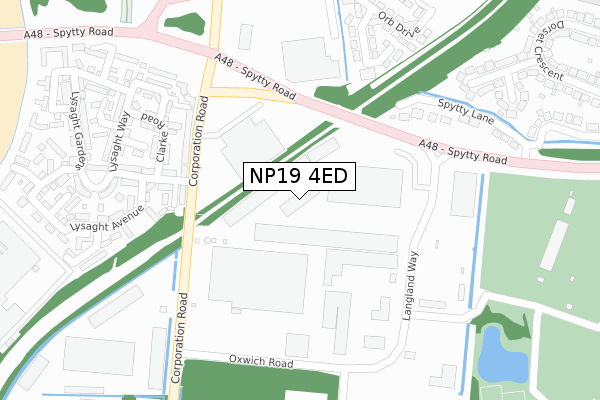
NP19 4ED is located in the Lliswerry electoral ward, within the unitary authority of Newport and the Welsh Parliamentary constituency of Newport East. The Local Health Board is Aneurin Bevan University and the police force is Gwent. This postcode has been in use since December 2017.


GetTheData
Source: OS Open Zoomstack (Ordnance Survey)
Licence: Open Government Licence (requires attribution)
Attribution: Contains OS data © Crown copyright and database right 2024
Source: Open Postcode Geo
Licence: Open Government Licence (requires attribution)
Attribution: Contains OS data © Crown copyright and database right 2024; Contains Royal Mail data © Royal Mail copyright and database right 2024; Source: Office for National Statistics licensed under the Open Government Licence v.3.0
| Easting | 333124 |
| Northing | 186620 |
| Latitude | 51.574464 |
| Longitude | -2.966411 |
GetTheData
Source: Open Postcode Geo
Licence: Open Government Licence
| Country | Wales |
| Postcode District | NP19 |
| ➜ NP19 open data dashboard ➜ See where NP19 is on a map ➜ Where is Newport? | |
GetTheData
Source: Land Registry Price Paid Data
Licence: Open Government Licence
| Ward | Lliswerry |
| Constituency | Newport East |
GetTheData
Source: ONS Postcode Database
Licence: Open Government Licence
| June 2022 | Violence and sexual offences | On or near Corporation Road | 201m |
| June 2022 | Anti-social behaviour | On or near Corporation Road | 201m |
| June 2022 | Other theft | On or near Corporation Road | 201m |
| ➜ Get more crime data in our Crime section | |||
GetTheData
Source: data.police.uk
Licence: Open Government Licence
| Santons (Spytty Road) | Liswerry | 145m |
| Santons (Spytty Road) | Liswerry | 164m |
| Reevesland Industrial Est (Corporation Road) | Liswerry | 267m |
| Reevesland Industrial Est (Corporation Road) | Liswerry | 283m |
| Carcraft (Spytty Road) | Liswerry | 332m |
| Newport (S Wales) Station | 2.9km |
GetTheData
Source: NaPTAN
Licence: Open Government Licence
GetTheData
Source: ONS Postcode Database
Licence: Open Government Licence


➜ Get more ratings from the Food Standards Agency
GetTheData
Source: Food Standards Agency
Licence: FSA terms & conditions
| Last Collection | |||
|---|---|---|---|
| Location | Mon-Fri | Sat | Distance |
| Aberthaw Circle | 17:30 | 11:15 | 836m |
| Vivian Road | 17:00 | 12:00 | 1,520m |
| Alexandra Road | 18:30 | 12:00 | 1,528m |
GetTheData
Source: Dracos
Licence: Creative Commons Attribution-ShareAlike
| School | Phase of Education | Distance |
|---|---|---|
| Catch22 Include Wales St Patrick's Rc Church Hall, Cromwell Road, Newport, NP19 0HS | Not applicable | 944m |
| Lliswerry High School Nash Road, Newport, NP19 4RP | Not applicable | 1km |
| St Patrick's R.C. Primary School Fairfax Road, Newport, NP19 0HR | Not applicable | 1km |
GetTheData
Source: Edubase
Licence: Open Government Licence
The below table lists the International Territorial Level (ITL) codes (formerly Nomenclature of Territorial Units for Statistics (NUTS) codes) and Local Administrative Units (LAU) codes for NP19 4ED:
| ITL 1 Code | Name |
|---|---|
| TLL | Wales |
| ITL 2 Code | Name |
| TLL2 | East Wales |
| ITL 3 Code | Name |
| TLL21 | Monmouthshire and Newport |
| LAU 1 Code | Name |
| W06000022 | Newport |
GetTheData
Source: ONS Postcode Directory
Licence: Open Government Licence
The below table lists the Census Output Area (OA), Lower Layer Super Output Area (LSOA), and Middle Layer Super Output Area (MSOA) for NP19 4ED:
| Code | Name | |
|---|---|---|
| OA | W00008541 | |
| LSOA | W01001647 | Newport 015F |
| MSOA | W02000361 | Newport 015 |
GetTheData
Source: ONS Postcode Directory
Licence: Open Government Licence
| NP19 4AF | Corporation Road | 204m |
| NP19 4AP | Clarke Road | 262m |
| NP19 0RH | Spytty Road | 275m |
| NP19 4AQ | Lockwood Court | 281m |
| NP19 4PT | Langland Way | 281m |
| NP19 4AN | Lysaght Way | 310m |
| NP19 4AL | Lysaght Way | 329m |
| NP19 4AG | Lysaght Circle | 343m |
| NP19 4AS | St Vincent Court | 353m |
| NP19 4AH | Lysaght Avenue | 370m |
GetTheData
Source: Open Postcode Geo; Land Registry Price Paid Data
Licence: Open Government Licence