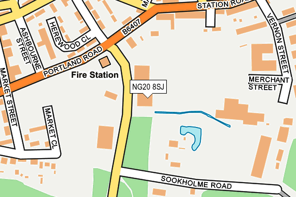
NG20 8SJ is located in the Shirebrook South electoral ward, within the local authority district of Bolsover and the English Parliamentary constituency of Bolsover. The Sub Integrated Care Board (ICB) Location is NHS Derby and Derbyshire ICB - 15M and the police force is Derbyshire. This postcode has been in use since July 2017.


GetTheData
Source: OS OpenMap – Local (Ordnance Survey)
Source: OS VectorMap District (Ordnance Survey)
Licence: Open Government Licence (requires attribution)
| Easting | 453029 |
| Northing | 367561 |
| Latitude | 53.202505 |
| Longitude | -1.207577 |
GetTheData
Source: Open Postcode Geo
Licence: Open Government Licence
| Country | England |
| Postcode District | NG20 |
| ➜ NG20 open data dashboard ➜ See where NG20 is on a map ➜ Where is Shirebrook? | |
GetTheData
Source: Land Registry Price Paid Data
Licence: Open Government Licence
| Ward | Shirebrook South |
| Constituency | Bolsover |
GetTheData
Source: ONS Postcode Database
Licence: Open Government Licence
| June 2023 | Violence and sexual offences | On or near Market Street | 281m |
| May 2023 | Other crime | On or near Market Street | 281m |
| May 2023 | Other crime | On or near Market Street | 281m |
| ➜ Get more crime data in our Crime section | |||
GetTheData
Source: data.police.uk
Licence: Open Government Licence
| Shire Hotel (Station Road) | Shirebrook | 187m |
| Shire Hotel (Station Road) | Shirebrook | 213m |
| Langwith Road End (Langwith Road) | Shirebrook | 252m |
| Langwith Road End (Langwith Road) | Shirebrook | 269m |
| Station Road | Shirebrook | 272m |
| Shirebrook Station | 0.4km |
| Langwith - Whaley Thorns Station | 3.3km |
| Mansfield Woodhouse Station | 4.3km |
GetTheData
Source: NaPTAN
Licence: Open Government Licence
GetTheData
Source: ONS Postcode Database
Licence: Open Government Licence


➜ Get more ratings from the Food Standards Agency
GetTheData
Source: Food Standards Agency
Licence: FSA terms & conditions
| Last Collection | |||
|---|---|---|---|
| Location | Mon-Fri | Sat | Distance |
| Station Road | 17:30 | 09:15 | 219m |
| Shirebrook Post Office | 17:00 | 11:00 | 373m |
| Main St / Central Drive | 17:00 | 09:15 | 691m |
GetTheData
Source: Dracos
Licence: Creative Commons Attribution-ShareAlike
| Facility | Distance |
|---|---|
| Shirebrook Recreation Ground Langwith Road, Shirebrook, Mansfield Grass Pitches | 393m |
| Everlast Gyms (Shirebrook) Weighbridge Road, Weighbridge Road, Shirebrook Health and Fitness Gym | 447m |
| Shirebrook Town Football Club Langwith Road, Shirebrook Grass Pitches | 517m |
GetTheData
Source: Active Places
Licence: Open Government Licence
| School | Phase of Education | Distance |
|---|---|---|
| St Joseph's Catholic Primary School, A Voluntary Academy Langwith Road, Langwith Junction, MANSFIELD, NG20 9RP | Primary | 716m |
| Model Village Primary School Central Drive, Shirebrook, Mansfield, NG20 8BQ | Primary | 802m |
| Brookfield Primary School Burlington Avenue, Langwith Junction, Mansfield, NG20 9AD | Primary | 1km |
GetTheData
Source: Edubase
Licence: Open Government Licence
The below table lists the International Territorial Level (ITL) codes (formerly Nomenclature of Territorial Units for Statistics (NUTS) codes) and Local Administrative Units (LAU) codes for NG20 8SJ:
| ITL 1 Code | Name |
|---|---|
| TLF | East Midlands (England) |
| ITL 2 Code | Name |
| TLF1 | Derbyshire and Nottinghamshire |
| ITL 3 Code | Name |
| TLF12 | East Derbyshire |
| LAU 1 Code | Name |
| E07000033 | Bolsover |
GetTheData
Source: ONS Postcode Directory
Licence: Open Government Licence
The below table lists the Census Output Area (OA), Lower Layer Super Output Area (LSOA), and Middle Layer Super Output Area (MSOA) for NG20 8SJ:
| Code | Name | |
|---|---|---|
| OA | E00098654 | |
| LSOA | E01019507 | Bolsover 007D |
| MSOA | E02004051 | Bolsover 007 |
GetTheData
Source: ONS Postcode Directory
Licence: Open Government Licence
| NG20 8UE | Station Road | 178m |
| NG20 8SZ | Station Road | 183m |
| NG20 8SQ | Hardwick Street | 199m |
| NG20 8UU | Hereward Close | 202m |
| NG20 8UT | Hereward Close | 203m |
| NG20 8UF | Station Road | 205m |
| NG20 8AE | Market Close | 227m |
| NG20 8TA | Station Road | 248m |
| NG20 8SF | Sookholme Road | 257m |
| NG20 8SH | Station Road | 258m |
GetTheData
Source: Open Postcode Geo; Land Registry Price Paid Data
Licence: Open Government Licence