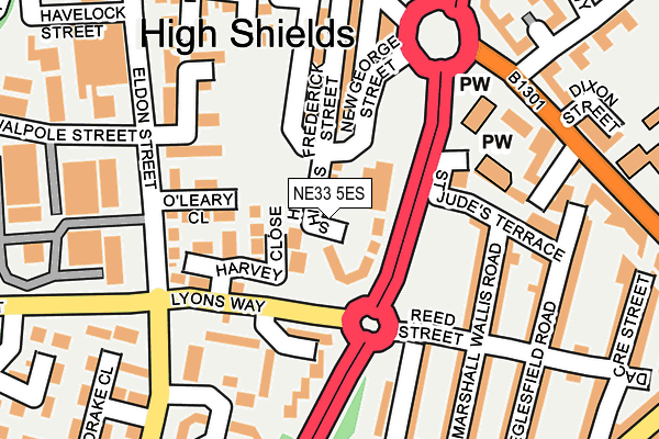
NE33 5ES is located in the Simonside and Rekendyke electoral ward, within the metropolitan district of South Tyneside and the English Parliamentary constituency of South Shields. The Sub Integrated Care Board (ICB) Location is NHS North East and North Cumbria ICB - 00N and the police force is Northumbria. This postcode has been in use since March 2017.


GetTheData
Source: OS OpenMap – Local (Ordnance Survey)
Source: OS VectorMap District (Ordnance Survey)
Licence: Open Government Licence (requires attribution)
| Easting | 436092 |
| Northing | 565967 |
| Latitude | 54.987004 |
| Longitude | -1.437527 |
GetTheData
Source: Open Postcode Geo
Licence: Open Government Licence
| Country | England |
| Postcode District | NE33 |
| ➜ NE33 open data dashboard ➜ See where NE33 is on a map ➜ Where is South Shields? | |
GetTheData
Source: Land Registry Price Paid Data
Licence: Open Government Licence
| Ward | Simonside And Rekendyke |
| Constituency | South Shields |
GetTheData
Source: ONS Postcode Database
Licence: Open Government Licence
| December 2023 | Vehicle crime | On or near Parking Area | 499m |
| November 2023 | Anti-social behaviour | On or near Brunswick Street | 388m |
| November 2023 | Violence and sexual offences | On or near Brunswick Street | 388m |
| ➜ Get more crime data in our Crime section | |||
GetTheData
Source: data.police.uk
Licence: Open Government Licence
| Reed Street | Laygate | 111m |
| Frederick Street | Laygate | 116m |
| Western Approach (A194) | Laygate | 118m |
| Reed Street | Laygate | 129m |
| South Eldon Street-drake Close (South Eldon Street) | Laygate | 208m |
| Chichester (Tyne And Wear Metro Station) (Laygate) | Chichester | 368m |
| Tyne Dock (Tyne And Wear Metro Station) (Napier Street) | Tyne Dock | 1,234m |
| South Shields (Tyne And Wear Metro Station) (Smithy Street) | South Shields | 1,293m |
| Brockley Whins Station | 3.4km |
| East Boldon Station | 4.6km |
GetTheData
Source: NaPTAN
Licence: Open Government Licence
➜ Broadband speed and availability dashboard for NE33 5ES
| Percentage of properties with Next Generation Access | 100.0% |
| Percentage of properties with Superfast Broadband | 100.0% |
| Percentage of properties with Ultrafast Broadband | 100.0% |
| Percentage of properties with Full Fibre Broadband | 0.0% |
Superfast Broadband is between 30Mbps and 300Mbps
Ultrafast Broadband is > 300Mbps
| Median download speed | 65.3Mbps |
| Average download speed | 70.6Mbps |
| Maximum download speed | 350.00Mbps |
| Median upload speed | 10.0Mbps |
| Average upload speed | 11.0Mbps |
| Maximum upload speed | 20.00Mbps |
| Percentage of properties unable to receive 2Mbps | 0.0% |
| Percentage of properties unable to receive 5Mbps | 0.0% |
| Percentage of properties unable to receive 10Mbps | 0.0% |
| Percentage of properties unable to receive 30Mbps | 0.0% |
➜ Broadband speed and availability dashboard for NE33 5ES
GetTheData
Source: Ofcom
Licence: Ofcom Terms of Use (requires attribution)
GetTheData
Source: ONS Postcode Database
Licence: Open Government Licence


➜ Get more ratings from the Food Standards Agency
GetTheData
Source: Food Standards Agency
Licence: FSA terms & conditions
| Last Collection | |||
|---|---|---|---|
| Location | Mon-Fri | Sat | Distance |
| Marshall Wallis Road | 17:00 | 10:00 | 161m |
| Green Street Post Office | 17:30 | 10:30 | 273m |
| Fraser Close | 17:00 | 10:00 | 394m |
GetTheData
Source: Dracos
Licence: Creative Commons Attribution-ShareAlike
| Facility | Distance |
|---|---|
| Trinity House Social Centre (Closed) Laygate, South Shields Health and Fitness Gym | 219m |
| Laygate Community School Laygate, South Shields Sports Hall, Grass Pitches | 339m |
| Kodokwai Judo Club Commercial Road, South Shields Health and Fitness Gym | 542m |
GetTheData
Source: Active Places
Licence: Open Government Licence
| School | Phase of Education | Distance |
|---|---|---|
| Laygate Community School Laygate Lane, South Shields, NE33 4JJ | Primary | 319m |
| St Bede's Catholic Primary School, South Shields Claypath Lane, South Shields, NE33 4PG | Primary | 825m |
| Stanhope Primary School Gresford Street, South Shields, NE33 4SZ | Primary | 947m |
GetTheData
Source: Edubase
Licence: Open Government Licence
The below table lists the International Territorial Level (ITL) codes (formerly Nomenclature of Territorial Units for Statistics (NUTS) codes) and Local Administrative Units (LAU) codes for NE33 5ES:
| ITL 1 Code | Name |
|---|---|
| TLC | North East (England) |
| ITL 2 Code | Name |
| TLC2 | Northumberland, and Tyne and Wear |
| ITL 3 Code | Name |
| TLC22 | Tyneside |
| LAU 1 Code | Name |
| E08000023 | South Tyneside |
GetTheData
Source: ONS Postcode Directory
Licence: Open Government Licence
The below table lists the Census Output Area (OA), Lower Layer Super Output Area (LSOA), and Middle Layer Super Output Area (MSOA) for NE33 5ES:
| Code | Name | |
|---|---|---|
| OA | E00043994 | |
| LSOA | E01008666 | South Tyneside 002C |
| MSOA | E02001769 | South Tyneside 002 |
GetTheData
Source: ONS Postcode Directory
Licence: Open Government Licence
| NE33 5EL | Lyons Way | 90m |
| NE33 5EN | Harvey Close | 95m |
| NE33 5AB | Sinclair Meadows | 102m |
| NE33 5EH | O'leary Close | 112m |
| NE33 5EF | Walpole Street | 121m |
| NE33 5PD | Marshall Wallis Road | 134m |
| NE33 5PG | Alice Street | 149m |
| NE33 5EJ | Eldon Street | 151m |
| NE33 5PE | Reed Street | 170m |
| NE33 5PB | St Judes Terrace | 181m |
GetTheData
Source: Open Postcode Geo; Land Registry Price Paid Data
Licence: Open Government Licence