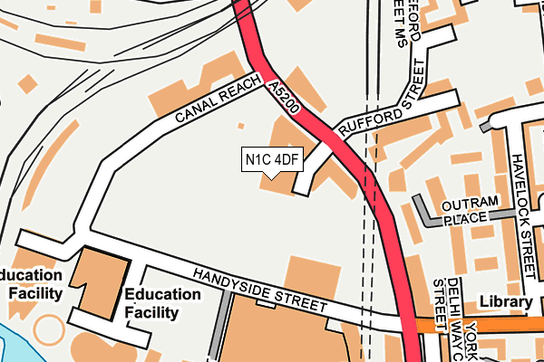
N1C 4DF is located in the King's Cross electoral ward, within the London borough of Camden and the English Parliamentary constituency of Holborn and St Pancras. The Sub Integrated Care Board (ICB) Location is NHS North Central London ICB - 93C and the police force is Metropolitan Police. This postcode has been in use since May 2017.


GetTheData
Source: OS OpenMap – Local (Ordnance Survey)
Source: OS VectorMap District (Ordnance Survey)
Licence: Open Government Licence (requires attribution)
| Easting | 530166 |
| Northing | 183836 |
| Latitude | 51.538428 |
| Longitude | -0.124522 |
GetTheData
Source: Open Postcode Geo
Licence: Open Government Licence
| Country | England |
| Postcode District | N1C |
| ➜ N1C open data dashboard ➜ See where N1C is on a map ➜ Where is London? | |
GetTheData
Source: Land Registry Price Paid Data
Licence: Open Government Licence
| Ward | King's Cross |
| Constituency | Holborn And St Pancras |
GetTheData
Source: ONS Postcode Database
Licence: Open Government Licence
| January 2024 | Criminal damage and arson | On or near Bingfield Street | 326m |
| January 2024 | Violence and sexual offences | On or near Bingfield Street | 326m |
| December 2023 | Possession of weapons | On or near Bingfield Street | 326m |
| ➜ Get more crime data in our Crime section | |||
GetTheData
Source: data.police.uk
Licence: Open Government Licence
| Randell's Road | Barnsbury | 81m |
| York Way Freight Lane | Barnsbury | 163m |
| Randell's Road (York Way) | Barnsbury | 186m |
| Copenhagen Street York Way (York Way) | King's Cross | 292m |
| York Way Kings Place (York Way) | King's Cross | 317m |
| King's Cross St. Pancras Underground Station | King's Cross | 869m |
| Mornington Crescent Underground Station | Mornington Crescent | 1,072m |
| Caledonian Road Underground Station | Caledonian Road | 1,199m |
| Camden Town Underground Station | Camden Town | 1,266m |
| Euston Underground Station | Euston | 1,325m |
| London St Pancras International Station | 0.7km |
| London St Pancras International LL Station | 0.7km |
| Caledonian Road & Barnsbury Station | 0.7km |
GetTheData
Source: NaPTAN
Licence: Open Government Licence
| Percentage of properties with Next Generation Access | 100.0% |
| Percentage of properties with Superfast Broadband | 100.0% |
| Percentage of properties with Ultrafast Broadband | 0.0% |
| Percentage of properties with Full Fibre Broadband | 0.0% |
Superfast Broadband is between 30Mbps and 300Mbps
Ultrafast Broadband is > 300Mbps
| Percentage of properties unable to receive 2Mbps | 0.0% |
| Percentage of properties unable to receive 5Mbps | 0.0% |
| Percentage of properties unable to receive 10Mbps | 0.0% |
| Percentage of properties unable to receive 30Mbps | 0.0% |
GetTheData
Source: Ofcom
Licence: Ofcom Terms of Use (requires attribution)
GetTheData
Source: ONS Postcode Database
Licence: Open Government Licence


➜ Get more ratings from the Food Standards Agency
GetTheData
Source: Food Standards Agency
Licence: FSA terms & conditions
| Last Collection | |||
|---|---|---|---|
| Location | Mon-Fri | Sat | Distance |
| 140 York Way | 18:30 | 12:00 | 255m |
| 320 Caledonian Road | 18:30 | 12:00 | 564m |
| Post Office | 19:00 | 13:00 | 576m |
GetTheData
Source: Dracos
Licence: Creative Commons Attribution-ShareAlike
| Facility | Distance |
|---|---|
| King's Cross Pond Club (Closed) Handyside Street, London Swimming Pool | 99m |
| Kings Cross Sports Hall York Way, Camden, London Sports Hall, Health and Fitness Gym | 102m |
| Frame (Kings Cross) York Way, London Studio | 449m |
GetTheData
Source: Active Places
Licence: Open Government Licence
| School | Phase of Education | Distance |
|---|---|---|
| Frank Barnes School for Deaf Children 4 Wollstonecraft Street, Kings Cross, London, N1C 4BT | Not applicable | 171m |
| Kings Cross Academy Plimsoll Building, 4 Wollstonecraft Street, London, N1C 4BT | Primary | 223m |
| Kate Greenaway Nursery School and Children's Centre Yorkway Court, Copenhagen Street, London, N1 0UH | Nursery | 357m |
GetTheData
Source: Edubase
Licence: Open Government Licence
The below table lists the International Territorial Level (ITL) codes (formerly Nomenclature of Territorial Units for Statistics (NUTS) codes) and Local Administrative Units (LAU) codes for N1C 4DF:
| ITL 1 Code | Name |
|---|---|
| TLI | London |
| ITL 2 Code | Name |
| TLI3 | Inner London - West |
| ITL 3 Code | Name |
| TLI31 | Camden and City of London |
| LAU 1 Code | Name |
| E09000007 | Camden |
GetTheData
Source: ONS Postcode Directory
Licence: Open Government Licence
The below table lists the Census Output Area (OA), Lower Layer Super Output Area (LSOA), and Middle Layer Super Output Area (MSOA) for N1C 4DF:
| Code | Name | |
|---|---|---|
| OA | E00004734 | |
| LSOA | E01000953 | Camden 022B |
| MSOA | E02000187 | Camden 022 |
GetTheData
Source: ONS Postcode Directory
Licence: Open Government Licence
| N1C 4AN | York Way | 57m |
| N1C 4AF | York Way | 72m |
| N1 0UX | Outram Place | 178m |
| N1 0AE | York Way | 183m |
| N1 0UN | Wheeler Gardens | 183m |
| N1 0DH | Randells Road | 199m |
| N1C 4BP | Handyside Street | 213m |
| N1C 4BQ | Handyside Street | 213m |
| N1C 4BR | Handyside Street | 213m |
| N1 0UR | Vibart Walk | 215m |
GetTheData
Source: Open Postcode Geo; Land Registry Price Paid Data
Licence: Open Government Licence