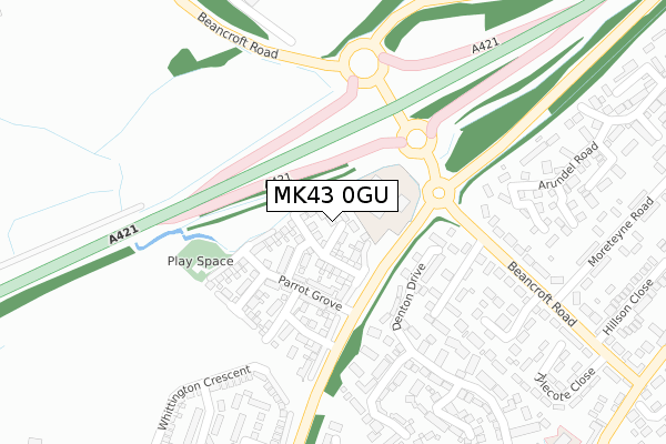
MK43 0GU maps, stats, and open data
MK43 0GU is located in the Cranfield & Marston Moretaine electoral ward, within the unitary authority of Central Bedfordshire and the English Parliamentary constituency of Mid Bedfordshire. The Sub Integrated Care Board (ICB) Location is NHS Bedfordshire, Luton and Milton Keynes ICB - M1J4Y and the police force is Bedfordshire. This postcode has been in use since November 2017.
MK43 0GU maps


Licence: Open Government Licence (requires attribution)
Attribution: Contains OS data © Crown copyright and database right 2025
Source: Open Postcode Geo
Licence: Open Government Licence (requires attribution)
Attribution: Contains OS data © Crown copyright and database right 2025; Contains Royal Mail data © Royal Mail copyright and database right 2025; Source: Office for National Statistics licensed under the Open Government Licence v.3.0
MK43 0GU geodata
| Easting | 499120 |
| Northing | 241705 |
| Latitude | 52.064872 |
| Longitude | -0.555472 |
Where is MK43 0GU?
| Country | England |
| Postcode District | MK43 |
Politics
| Ward | Cranfield & Marston Moretaine |
|---|---|
| Constituency | Mid Bedfordshire |
House Prices
Sales of detached houses in MK43 0GU
2025 28 MAR £422,500 |
18, GOODMAN CROFT, MARSTON MORETAINE, BEDFORD, MK43 0GU 2018 29 MAR £409,995 |
16, GOODMAN CROFT, MARSTON MORETAINE, BEDFORD, MK43 0GU 2018 23 MAR £279,995 |
17, GOODMAN CROFT, MARSTON MORETAINE, BEDFORD, MK43 0GU 2018 23 MAR £279,995 |
19, GOODMAN CROFT, MARSTON MORETAINE, BEDFORD, MK43 0GU 2018 22 FEB £409,995 |
2017 31 OCT £379,995 |
➜ Marston Moretaine house prices
Licence: Contains HM Land Registry data © Crown copyright and database right 2025. This data is licensed under the Open Government Licence v3.0.
Transport
Nearest bus stops to MK43 0GU
| Chandlers Close (Beancroft Road) | Marston Moretaine | 240m |
| Chandlers Close (Beancroft Road) | Marston Moretaine | 264m |
| Moreteyne Road (Beancroft Road) | Marston Moretaine | 329m |
| Moreteyne Road (Beancroft Road) | Marston Moretaine | 358m |
| Tylecote Close (Beancroft Road) | Marston Moretaine | 466m |
Nearest railway stations to MK43 0GU
| Millbrook (Beds) Station | 2km |
| Stewartby Station | 2.4km |
| Lidlington Station | 2.6km |
Broadband
Broadband access in MK43 0GU (2020 data)
| Percentage of properties with Next Generation Access | 0.0% |
| Percentage of properties with Superfast Broadband | 0.0% |
| Percentage of properties with Ultrafast Broadband | 0.0% |
| Percentage of properties with Full Fibre Broadband | 0.0% |
Superfast Broadband is between 30Mbps and 300Mbps
Ultrafast Broadband is > 300Mbps
Broadband speed in MK43 0GU (2019 data)
Download
| Median download speed | 2.4Mbps |
| Average download speed | 2.6Mbps |
| Maximum download speed | 3.81Mbps |
Upload
| Median upload speed | 0.4Mbps |
| Average upload speed | 0.6Mbps |
| Maximum upload speed | 1.02Mbps |
Broadband limitations in MK43 0GU (2020 data)
| Percentage of properties unable to receive 2Mbps | 0.0% |
| Percentage of properties unable to receive 5Mbps | 100.0% |
| Percentage of properties unable to receive 10Mbps | 100.0% |
| Percentage of properties unable to receive 30Mbps | 100.0% |
Deprivation
13.9% of English postcodes are less deprived than MK43 0GU:Food Standards Agency
Three nearest food hygiene ratings to MK43 0GU (metres)


➜ Get more ratings from the Food Standards Agency
Nearest post box to MK43 0GU
| Last Collection | |||
|---|---|---|---|
| Location | Mon-Fri | Sat | Distance |
| Post Office Bedford Road | 16:15 | 11:00 | 533m |
| Manor Road | 16:10 | 10:55 | 599m |
| Lower Shelton | 16:20 | 11:10 | 1,135m |
MK43 0GU ITL and MK43 0GU LAU
The below table lists the International Territorial Level (ITL) codes (formerly Nomenclature of Territorial Units for Statistics (NUTS) codes) and Local Administrative Units (LAU) codes for MK43 0GU:
| ITL 1 Code | Name |
|---|---|
| TLH | East |
| ITL 2 Code | Name |
| TLH2 | Bedfordshire and Hertfordshire |
| ITL 3 Code | Name |
| TLH25 | Central Bedfordshire |
| LAU 1 Code | Name |
| E06000056 | Central Bedfordshire |
MK43 0GU census areas
The below table lists the Census Output Area (OA), Lower Layer Super Output Area (LSOA), and Middle Layer Super Output Area (MSOA) for MK43 0GU:
| Code | Name | |
|---|---|---|
| OA | E00087954 | |
| LSOA | E01017417 | Central Bedfordshire 009B |
| MSOA | E02003607 | Central Bedfordshire 009 |
Nearest postcodes to MK43 0GU
| MK43 0FE | Denton Drive | 161m |
| MK43 0FF | Denton Drive | 172m |
| MK43 0QW | Chandlers Close | 211m |
| MK43 0PZ | Beancroft Road | 258m |
| MK43 0AE | Moat Farm Close | 289m |
| MK43 0QB | Churchill Road | 292m |
| MK43 0JT | Johnson Close | 309m |
| MK43 0JE | Owen Close | 316m |
| MK43 0AQ | Deacon Mews | 340m |
| MK43 0NA | Denton Drive | 347m |