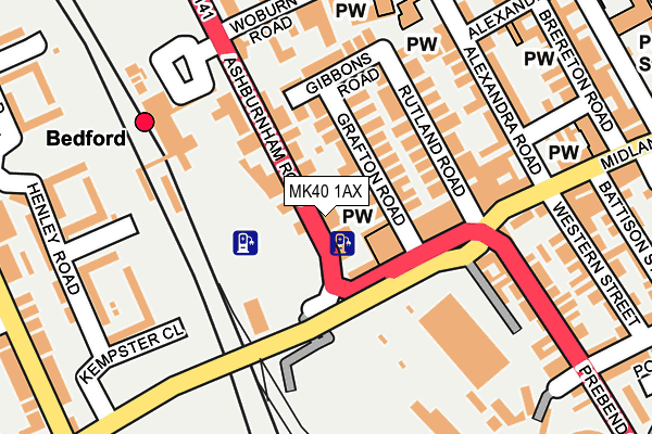
MK40 1AX is located in the Greyfriars electoral ward, within the unitary authority of Bedford and the English Parliamentary constituency of Bedford. The Sub Integrated Care Board (ICB) Location is NHS Bedfordshire, Luton and Milton Keynes ICB - M1J4Y and the police force is Bedfordshire. This postcode has been in use since July 2017.


GetTheData
Source: OS OpenMap – Local (Ordnance Survey)
Source: OS VectorMap District (Ordnance Survey)
Licence: Open Government Licence (requires attribution)
| Easting | 504320 |
| Northing | 249655 |
| Latitude | 52.135369 |
| Longitude | -0.477213 |
GetTheData
Source: Open Postcode Geo
Licence: Open Government Licence
| Country | England |
| Postcode District | MK40 |
| ➜ MK40 open data dashboard ➜ See where MK40 is on a map ➜ Where is Bedford? | |
GetTheData
Source: Land Registry Price Paid Data
Licence: Open Government Licence
| Ward | Greyfriars |
| Constituency | Bedford |
GetTheData
Source: ONS Postcode Database
Licence: Open Government Licence
| December 2023 | Burglary | On or near Alexandra Road | 196m |
| November 2023 | Criminal damage and arson | On or near Alexandra Road | 196m |
| November 2023 | Criminal damage and arson | On or near Alexandra Road | 196m |
| ➜ Get more crime data in our Crime section | |||
GetTheData
Source: data.police.uk
Licence: Open Government Licence
| Bedford Railway Station (Ashburnham Road) | Bedford | 114m |
| Bedford Railway Station (Ashburnham Road) | Bedford | 179m |
| Bedford Railway Station (Ashburnum Road) | Bedford | 182m |
| Alexandra Road (Midland Road) | Bedford | 218m |
| Alexandra Road (Midland Road) | Bedford | 223m |
| Bedford Station | 0.2km |
| Bedford St Johns Station | 0.9km |
| Kempston Hardwick Station | 5.1km |
GetTheData
Source: NaPTAN
Licence: Open Government Licence
| Percentage of properties with Next Generation Access | 100.0% |
| Percentage of properties with Superfast Broadband | 100.0% |
| Percentage of properties with Ultrafast Broadband | 100.0% |
| Percentage of properties with Full Fibre Broadband | 0.0% |
Superfast Broadband is between 30Mbps and 300Mbps
Ultrafast Broadband is > 300Mbps
| Percentage of properties unable to receive 2Mbps | 0.0% |
| Percentage of properties unable to receive 5Mbps | 0.0% |
| Percentage of properties unable to receive 10Mbps | 0.0% |
| Percentage of properties unable to receive 30Mbps | 0.0% |
GetTheData
Source: Ofcom
Licence: Ofcom Terms of Use (requires attribution)
GetTheData
Source: ONS Postcode Database
Licence: Open Government Licence


➜ Get more ratings from the Food Standards Agency
GetTheData
Source: Food Standards Agency
Licence: FSA terms & conditions
| Last Collection | |||
|---|---|---|---|
| Location | Mon-Fri | Sat | Distance |
| Bedford Delivery Office | 19:15 | 13:00 | 133m |
| Bedford Letter Sorting Office | 19:20 | 13:00 | 135m |
| Woburn Road | 18:45 | 12:00 | 197m |
GetTheData
Source: Dracos
Licence: Creative Commons Attribution-ShareAlike
| Facility | Distance |
|---|---|
| Samsons Fitness Midland Road, Bedford Health and Fitness Gym | 225m |
| Energie Fitness (Bedford) Horne Lane, Horne Lane, Bedford Health and Fitness Gym | 546m |
| Anytime Fitness (Bedford) Riverside Square, Riverside Square, Bedford Health and Fitness Gym | 581m |
GetTheData
Source: Active Places
Licence: Open Government Licence
| School | Phase of Education | Distance |
|---|---|---|
| Priory Primary School Greyfriars, Bedford, MK40 1JD | Primary | 316m |
| Polam School 45 Lansdowne Road, Bedford, MK40 2BU | Not applicable | 588m |
| Bedford College Cauldwell Street, Bedford, MK42 9AH | 16 plus | 675m |
GetTheData
Source: Edubase
Licence: Open Government Licence
The below table lists the International Territorial Level (ITL) codes (formerly Nomenclature of Territorial Units for Statistics (NUTS) codes) and Local Administrative Units (LAU) codes for MK40 1AX:
| ITL 1 Code | Name |
|---|---|
| TLH | East |
| ITL 2 Code | Name |
| TLH2 | Bedfordshire and Hertfordshire |
| ITL 3 Code | Name |
| TLH24 | Bedford |
| LAU 1 Code | Name |
| E06000055 | Bedford |
GetTheData
Source: ONS Postcode Directory
Licence: Open Government Licence
The below table lists the Census Output Area (OA), Lower Layer Super Output Area (LSOA), and Middle Layer Super Output Area (MSOA) for MK40 1AX:
| Code | Name | |
|---|---|---|
| OA | E00088222 | |
| LSOA | E01017466 | Bedford 012A |
| MSOA | E02003627 | Bedford 012 |
GetTheData
Source: ONS Postcode Directory
Licence: Open Government Licence
| MK40 1DW | Midland Road | 62m |
| MK40 1DX | Ashburnham Road | 64m |
| MK40 1DJ | Grafton Road | 74m |
| MK40 1DH | Grafton Road | 75m |
| MK40 1DS | Ashburnham Road | 98m |
| MK40 1DN | Midland Road | 109m |
| MK40 1DG | Rutland Road | 138m |
| MK40 1DQ | Gibbons Road | 142m |
| MK40 1DE | Midland Road | 155m |
| MK40 1DY | Ashburnham Road | 172m |
GetTheData
Source: Open Postcode Geo; Land Registry Price Paid Data
Licence: Open Government Licence