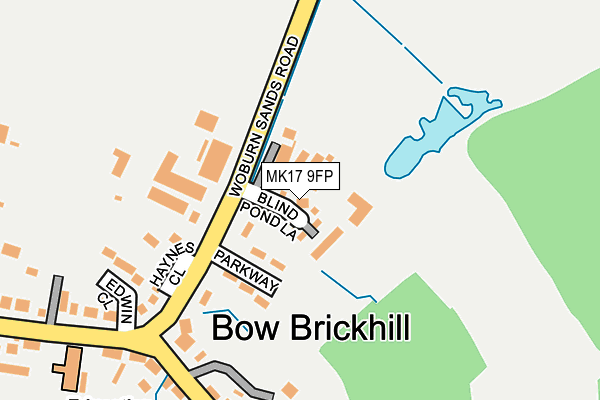
MK17 9FP is located in the Danesborough & Walton electoral ward, within the unitary authority of Milton Keynes and the English Parliamentary constituency of Milton Keynes South. The Sub Integrated Care Board (ICB) Location is NHS Bedfordshire, Luton and Milton Keynes ICB - M1J4Y and the police force is Thames Valley. This postcode has been in use since March 2017.


GetTheData
Source: OS OpenMap – Local (Ordnance Survey)
Source: OS VectorMap District (Ordnance Survey)
Licence: Open Government Licence (requires attribution)
| Easting | 490839 |
| Northing | 234737 |
| Latitude | 52.003659 |
| Longitude | -0.678083 |
GetTheData
Source: Open Postcode Geo
Licence: Open Government Licence
| Country | England |
| Postcode District | MK17 |
| ➜ MK17 open data dashboard ➜ See where MK17 is on a map ➜ Where is Bow Brickhill? | |
GetTheData
Source: Land Registry Price Paid Data
Licence: Open Government Licence
| Ward | Danesborough & Walton |
| Constituency | Milton Keynes South |
GetTheData
Source: ONS Postcode Database
Licence: Open Government Licence
| November 2023 | Drugs | On or near Church Road | 321m |
| August 2022 | Violence and sexual offences | On or near Church Road | 321m |
| June 2022 | Anti-social behaviour | On or near Edwin Close | 202m |
| ➜ Get more crime data in our Crime section | |||
GetTheData
Source: data.police.uk
Licence: Open Government Licence
| Parkway (Station Road) | Bow Brickhill | 69m |
| Parkway (Station Road) | Bow Brickhill | 109m |
| Bow Brickhill School (Station Road) | Bow Brickhill | 280m |
| Bow Brickhill School (Station Road) | Bow Brickhill | 331m |
| The Wheatsheaf (Station Road) | Bow Brickhill | 591m |
| Bow Brickhill Station | 1.2km |
| Woburn Sands Station | 2.3km |
| Fenny Stratford Station | 2.6km |
GetTheData
Source: NaPTAN
Licence: Open Government Licence
➜ Broadband speed and availability dashboard for MK17 9FP
| Percentage of properties with Next Generation Access | 100.0% |
| Percentage of properties with Superfast Broadband | 100.0% |
| Percentage of properties with Ultrafast Broadband | 0.0% |
| Percentage of properties with Full Fibre Broadband | 0.0% |
Superfast Broadband is between 30Mbps and 300Mbps
Ultrafast Broadband is > 300Mbps
| Median download speed | 39.1Mbps |
| Average download speed | 39.8Mbps |
| Maximum download speed | 78.12Mbps |
| Median upload speed | 9.7Mbps |
| Average upload speed | 9.8Mbps |
| Maximum upload speed | 19.53Mbps |
| Percentage of properties unable to receive 2Mbps | 0.0% |
| Percentage of properties unable to receive 5Mbps | 0.0% |
| Percentage of properties unable to receive 10Mbps | 0.0% |
| Percentage of properties unable to receive 30Mbps | 0.0% |
➜ Broadband speed and availability dashboard for MK17 9FP
GetTheData
Source: Ofcom
Licence: Ofcom Terms of Use (requires attribution)
GetTheData
Source: ONS Postcode Database
Licence: Open Government Licence


➜ Get more ratings from the Food Standards Agency
GetTheData
Source: Food Standards Agency
Licence: FSA terms & conditions
| Last Collection | |||
|---|---|---|---|
| Location | Mon-Fri | Sat | Distance |
| Woburn Sands Road | 17:45 | 08:15 | 191m |
| Hill Top | 16:00 | 08:15 | 315m |
| Station Road | 17:45 | 08:15 | 610m |
GetTheData
Source: Dracos
Licence: Creative Commons Attribution-ShareAlike
| Facility | Distance |
|---|---|
| Bow Brickhill Playing Fields Rushmere Close, Bow Brickhill, Milton Keynes Grass Pitches | 315m |
| Browns Wood Sports Ground Browns Wood, Milton Keynes Grass Pitches, Cycling | 1.1km |
| Woburn Golf Club Little Brickhill, Milton Keynes Swimming Pool, Golf | 1.6km |
GetTheData
Source: Active Places
Licence: Open Government Licence
| School | Phase of Education | Distance |
|---|---|---|
| Bow Brickhill CofE VA Primary School Station Road, Bow Brickhill, Milton Keynes, MK17 9JT | Primary | 307m |
| Heronshaw School Lichfield Down, Walnut Tree, Milton Keynes, MK7 7PG | Primary | 1.8km |
| Heronsgate School Lichfield Down, Walnut Tree, Milton Keynes, MK7 7BW | Primary | 1.8km |
GetTheData
Source: Edubase
Licence: Open Government Licence
The below table lists the International Territorial Level (ITL) codes (formerly Nomenclature of Territorial Units for Statistics (NUTS) codes) and Local Administrative Units (LAU) codes for MK17 9FP:
| ITL 1 Code | Name |
|---|---|
| TLJ | South East (England) |
| ITL 2 Code | Name |
| TLJ1 | Berkshire, Buckinghamshire and Oxfordshire |
| ITL 3 Code | Name |
| TLJ12 | Milton Keynes |
| LAU 1 Code | Name |
| E06000042 | Milton Keynes |
GetTheData
Source: ONS Postcode Directory
Licence: Open Government Licence
The below table lists the Census Output Area (OA), Lower Layer Super Output Area (LSOA), and Middle Layer Super Output Area (MSOA) for MK17 9FP:
| Code | Name | |
|---|---|---|
| OA | E00084446 | |
| LSOA | E01016734 | Milton Keynes 024A |
| MSOA | E02003482 | Milton Keynes 024 |
GetTheData
Source: ONS Postcode Directory
Licence: Open Government Licence
| MK17 9JZ | Park Way | 102m |
| MK17 9JQ | Haynes Close | 159m |
| MK17 9LA | Woburn Sands Road | 183m |
| MK17 9JY | Manor Farm Fields | 188m |
| MK17 9JX | Edwin Close | 189m |
| MK17 9LH | Church Road | 256m |
| MK17 9LD | Church Road | 267m |
| MK17 9LE | London End Lane | 271m |
| MK17 9JT | Station Road | 307m |
| MK17 9JF | Grovesbrook | 351m |
GetTheData
Source: Open Postcode Geo; Land Registry Price Paid Data
Licence: Open Government Licence