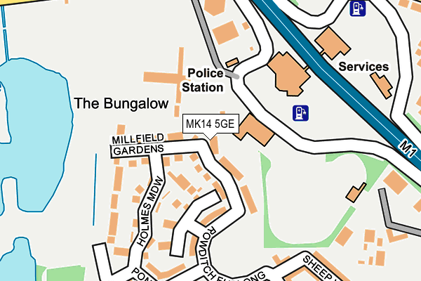
MK14 5GE is located in the Newport Pagnell North & Hanslope electoral ward, within the unitary authority of Milton Keynes and the English Parliamentary constituency of Milton Keynes North. The Sub Integrated Care Board (ICB) Location is NHS Bedfordshire, Luton and Milton Keynes ICB - M1J4Y and the police force is Thames Valley. This postcode has been in use since March 2017.


GetTheData
Source: OS OpenMap – Local (Ordnance Survey)
Source: OS VectorMap District (Ordnance Survey)
Licence: Open Government Licence (requires attribution)
| Easting | 485702 |
| Northing | 243398 |
| Latitude | 52.082325 |
| Longitude | -0.750730 |
GetTheData
Source: Open Postcode Geo
Licence: Open Government Licence
| Country | England |
| Postcode District | MK14 |
| ➜ MK14 open data dashboard ➜ See where MK14 is on a map ➜ Where is Milton Keynes? | |
GetTheData
Source: Land Registry Price Paid Data
Licence: Open Government Licence
| Ward | Newport Pagnell North & Hanslope |
| Constituency | Milton Keynes North |
GetTheData
Source: ONS Postcode Database
Licence: Open Government Licence
| January 2024 | Criminal damage and arson | On or near Petrol Station | 53m |
| January 2024 | Anti-social behaviour | On or near Petrol Station | 53m |
| January 2024 | Violence and sexual offences | On or near Hopcrofts Meadow | 319m |
| ➜ Get more crime data in our Crime section | |||
GetTheData
Source: data.police.uk
Licence: Open Government Licence
| Top Fair Furlong | Redhouse Park | 180m |
| Top Fair Furlong | Redhouse Park | 220m |
| Giffard Park Roundabout East (Wolverton Road) | Giffard Park | 378m |
| Giffard Park Roundabout East (Wolverton Road) | Giffard Park | 394m |
| Wordsworth Avenue South (Wordsworth Avenue (N)) | Newport Pagnell | 430m |
| Wolverton Station | 4.1km |
GetTheData
Source: NaPTAN
Licence: Open Government Licence
| Percentage of properties with Next Generation Access | 100.0% |
| Percentage of properties with Superfast Broadband | 100.0% |
| Percentage of properties with Ultrafast Broadband | 0.0% |
| Percentage of properties with Full Fibre Broadband | 0.0% |
Superfast Broadband is between 30Mbps and 300Mbps
Ultrafast Broadband is > 300Mbps
| Percentage of properties unable to receive 2Mbps | 0.0% |
| Percentage of properties unable to receive 5Mbps | 0.0% |
| Percentage of properties unable to receive 10Mbps | 0.0% |
| Percentage of properties unable to receive 30Mbps | 0.0% |
GetTheData
Source: Ofcom
Licence: Ofcom Terms of Use (requires attribution)
GetTheData
Source: ONS Postcode Database
Licence: Open Government Licence


➜ Get more ratings from the Food Standards Agency
GetTheData
Source: Food Standards Agency
Licence: FSA terms & conditions
| Last Collection | |||
|---|---|---|---|
| Location | Mon-Fri | Sat | Distance |
| Pennycress Way | 17:30 | 12:00 | 297m |
| Wordsworth Avenue | 17:15 | 12:00 | 553m |
| Station Terrace | 16:30 | 12:00 | 648m |
GetTheData
Source: Dracos
Licence: Creative Commons Attribution-ShareAlike
| Facility | Distance |
|---|---|
| Portfields Primary School Westbury Lane, Newport Pagnell Grass Pitches | 783m |
| Giffard Park Primary School Broadway Avenue, Giffard Park, Milton Keynes Grass Pitches | 1km |
| Ousedale School (Newport Pagnell Campus) The Grove, Newport Pagnell Sports Hall, Artificial Grass Pitch, Grass Pitches, Squash Courts, Health and Fitness Gym, Studio | 1.1km |
GetTheData
Source: Active Places
Licence: Open Government Licence
| School | Phase of Education | Distance |
|---|---|---|
| Portfields Primary School Westbury Lane, Newport Pagnell, MK16 8PS | Primary | 783m |
| Giffard Park Primary School Broadway Avenue, Giffard Park, Giffard Park Primary School, Milton Keynes, MK14 5PY | Primary | 1km |
| Ousedale School The Grove, Newport Pagnell, MK16 0BJ | Secondary | 1.1km |
GetTheData
Source: Edubase
Licence: Open Government Licence
The below table lists the International Territorial Level (ITL) codes (formerly Nomenclature of Territorial Units for Statistics (NUTS) codes) and Local Administrative Units (LAU) codes for MK14 5GE:
| ITL 1 Code | Name |
|---|---|
| TLJ | South East (England) |
| ITL 2 Code | Name |
| TLJ1 | Berkshire, Buckinghamshire and Oxfordshire |
| ITL 3 Code | Name |
| TLJ12 | Milton Keynes |
| LAU 1 Code | Name |
| E06000042 | Milton Keynes |
GetTheData
Source: ONS Postcode Directory
Licence: Open Government Licence
The below table lists the Census Output Area (OA), Lower Layer Super Output Area (LSOA), and Middle Layer Super Output Area (MSOA) for MK14 5GE:
| Code | Name | |
|---|---|---|
| OA | E00175465 | |
| LSOA | E01016760 | Milton Keynes 002B |
| MSOA | E02003460 | Milton Keynes 002 |
GetTheData
Source: ONS Postcode Directory
Licence: Open Government Licence
| MK14 5GB | Rowditch Furlong | 50m |
| MK14 5FZ | Rowditch Furlong | 84m |
| MK14 5FU | Rowditch Furlong | 101m |
| MK14 5GH | Millfield Gardens | 104m |
| MK14 5FD | Rowditch Furlong | 117m |
| MK14 5GF | Holmes Meadow | 125m |
| MK14 5GG | Skinners Close | 182m |
| MK14 5FB | Pond Gate | 229m |
| MK14 5FP | Sheep Way | 256m |
| MK14 5FN | Rowditch Furlong | 264m |
GetTheData
Source: Open Postcode Geo; Land Registry Price Paid Data
Licence: Open Government Licence