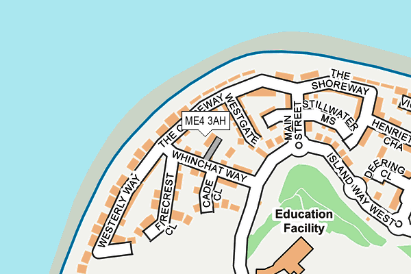
ME4 3AH is located in the St Mary's Island electoral ward, within the unitary authority of Medway and the English Parliamentary constituency of Rochester and Strood. The Sub Integrated Care Board (ICB) Location is NHS Kent and Medway ICB - 91Q and the police force is Kent. This postcode has been in use since March 2017.


GetTheData
Source: OS OpenMap – Local (Ordnance Survey)
Source: OS VectorMap District (Ordnance Survey)
Licence: Open Government Licence (requires attribution)
| Easting | 576491 |
| Northing | 170841 |
| Latitude | 51.409125 |
| Longitude | 0.536337 |
GetTheData
Source: Open Postcode Geo
Licence: Open Government Licence
| Country | England |
| Postcode District | ME4 |
| ➜ ME4 open data dashboard ➜ See where ME4 is on a map ➜ Where is Gillingham? | |
GetTheData
Source: Land Registry Price Paid Data
Licence: Open Government Licence
| Ward | St Mary's Island |
| Constituency | Rochester And Strood |
GetTheData
Source: ONS Postcode Database
Licence: Open Government Licence
| January 2024 | Criminal damage and arson | On or near Little Victory Mount | 368m |
| May 2023 | Anti-social behaviour | On or near Little Victory Mount | 368m |
| April 2023 | Burglary | On or near Little Victory Mount | 368m |
| ➜ Get more crime data in our Crime section | |||
GetTheData
Source: data.police.uk
Licence: Open Government Licence
| Primary School (Island Way West) | St Mary's Island | 174m |
| Tappan Drive (Island Way West) | St Mary's Island | 257m |
| Upnor Pier Brissenden Close (Upnor Road) | Lower Upnor | 498m |
| Galleon Way (Upnor Road) | Lower Upnor | 542m |
| Haven Way (Island Way East) | St Mary's Island | 544m |
| Gillingham (Kent) Station | 2.7km |
| Strood Station | 2.9km |
| Rochester Station | 3.2km |
GetTheData
Source: NaPTAN
Licence: Open Government Licence
| Percentage of properties with Next Generation Access | 100.0% |
| Percentage of properties with Superfast Broadband | 100.0% |
| Percentage of properties with Ultrafast Broadband | 100.0% |
| Percentage of properties with Full Fibre Broadband | 100.0% |
Superfast Broadband is between 30Mbps and 300Mbps
Ultrafast Broadband is > 300Mbps
| Percentage of properties unable to receive 2Mbps | 0.0% |
| Percentage of properties unable to receive 5Mbps | 0.0% |
| Percentage of properties unable to receive 10Mbps | 0.0% |
| Percentage of properties unable to receive 30Mbps | 0.0% |
GetTheData
Source: Ofcom
Licence: Ofcom Terms of Use (requires attribution)
GetTheData
Source: ONS Postcode Database
Licence: Open Government Licence

➜ Get more ratings from the Food Standards Agency
GetTheData
Source: Food Standards Agency
Licence: FSA terms & conditions
| Last Collection | |||
|---|---|---|---|
| Location | Mon-Fri | Sat | Distance |
| Lower Upnor | 17:30 | 09:00 | 501m |
| St Marys Island | 17:30 | 11:30 | 535m |
| Dockhead Road | 17:30 | 11:00 | 844m |
GetTheData
Source: Dracos
Licence: Creative Commons Attribution-ShareAlike
| Facility | Distance |
|---|---|
| St Marys Island Ce Primary School Island Way West, St. Marys Island, Chatham Grass Pitches | 210m |
| Arethusa Venture Centre (Closed) Lower Upnor, Upnor, Rochester Grass Pitches, Sports Hall, Swimming Pool | 527m |
| Trugym (Chatham) Dock Head Road, Chatham Maritime, Chatham Health and Fitness Gym, Studio | 780m |
GetTheData
Source: Active Places
Licence: Open Government Licence
| School | Phase of Education | Distance |
|---|---|---|
| St Mary's Island Church of England (Aided) Primary School Island Way West, St Mary's Island, Chatham, ME4 3ST | Primary | 203m |
| Chattenden Primary School Chattenden Lane, Chattenden, Rochester, ME3 8LF | Primary | 1.2km |
| Waterfront UTC South Side Three Road, Chatham, ME4 4FQ | Secondary | 1.5km |
GetTheData
Source: Edubase
Licence: Open Government Licence
The below table lists the International Territorial Level (ITL) codes (formerly Nomenclature of Territorial Units for Statistics (NUTS) codes) and Local Administrative Units (LAU) codes for ME4 3AH:
| ITL 1 Code | Name |
|---|---|
| TLJ | South East (England) |
| ITL 2 Code | Name |
| TLJ4 | Kent |
| ITL 3 Code | Name |
| TLJ41 | Medway |
| LAU 1 Code | Name |
| E06000035 | Medway |
GetTheData
Source: ONS Postcode Directory
Licence: Open Government Licence
The below table lists the Census Output Area (OA), Lower Layer Super Output Area (LSOA), and Middle Layer Super Output Area (MSOA) for ME4 3AH:
| Code | Name | |
|---|---|---|
| OA | E00167400 | |
| LSOA | E01016112 | Medway 007D |
| MSOA | E02003320 | Medway 007 |
GetTheData
Source: ONS Postcode Directory
Licence: Open Government Licence
| ME4 3SQ | The Causeway | 58m |
| ME4 3SG | Westgate | 67m |
| ME4 3SR | The Causeway | 93m |
| ME4 3SE | Main Street | 125m |
| ME4 3SF | Main Street | 148m |
| ME4 3SL | Stillwater Mews | 170m |
| ME4 3SW | Island Way West | 175m |
| ME4 3SS | The Shoreway | 211m |
| ME4 3SU | The Shoreway | 215m |
| ME4 3SJ | Westview | 218m |
GetTheData
Source: Open Postcode Geo; Land Registry Price Paid Data
Licence: Open Government Licence