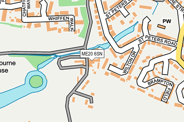
ME20 6SN is located in the Aylesford South & Ditton electoral ward, within the local authority district of Tonbridge and Malling and the English Parliamentary constituency of Chatham and Aylesford. The Sub Integrated Care Board (ICB) Location is NHS Kent and Medway ICB - 91Q and the police force is Kent. This postcode has been in use since April 2017.


GetTheData
Source: OS OpenMap – Local (Ordnance Survey)
Source: OS VectorMap District (Ordnance Survey)
Licence: Open Government Licence (requires attribution)
| Easting | 570750 |
| Northing | 157930 |
| Latitude | 51.294896 |
| Longitude | 0.447681 |
GetTheData
Source: Open Postcode Geo
Licence: Open Government Licence
| Country | England |
| Postcode District | ME20 |
| ➜ ME20 open data dashboard ➜ See where ME20 is on a map ➜ Where is Ditton? | |
GetTheData
Source: Land Registry Price Paid Data
Licence: Open Government Licence
| Ward | Aylesford South & Ditton |
| Constituency | Chatham And Aylesford |
GetTheData
Source: ONS Postcode Database
Licence: Open Government Licence
| January 2024 | Violence and sexual offences | On or near Garner Drive | 451m |
| October 2023 | Violence and sexual offences | On or near St Peters Road | 200m |
| October 2023 | Public order | On or near St Peters Road | 200m |
| ➜ Get more crime data in our Crime section | |||
GetTheData
Source: data.police.uk
Licence: Open Government Licence
| Bell Lane (London Road) | Ditton | 506m |
| Wealden Hall (London Road) | Larkfield | 527m |
| Wealden Hall (London Road) | Larkfield | 533m |
| Bell Lane (London Road) | Ditton | 541m |
| Ditton Corner (London Road) | Ditton | 631m |
| East Malling Station | 1.2km |
| Aylesford Station | 1.5km |
| West Malling Station | 2km |
GetTheData
Source: NaPTAN
Licence: Open Government Licence
GetTheData
Source: ONS Postcode Database
Licence: Open Government Licence


➜ Get more ratings from the Food Standards Agency
GetTheData
Source: Food Standards Agency
Licence: FSA terms & conditions
| Last Collection | |||
|---|---|---|---|
| Location | Mon-Fri | Sat | Distance |
| St Peters Road | 16:15 | 09:00 | 217m |
| Bradbourne Park Road | 17:00 | 09:00 | 496m |
| Ditton Post Office | 17:00 | 11:00 | 505m |
GetTheData
Source: Dracos
Licence: Creative Commons Attribution-ShareAlike
| Facility | Distance |
|---|---|
| Ditton C Of E Junior School New Road, Ditton, Aylesford Grass Pitches | 379m |
| Bradbourne House (The Stables) East Malling, West Malling Grass Pitches | 508m |
| New Road Recreation Ground New Road, Ditton, Aylesford Grass Pitches | 527m |
GetTheData
Source: Active Places
Licence: Open Government Licence
| School | Phase of Education | Distance |
|---|---|---|
| Ditton Church of England Junior School New Road, Ditton, Aylesford, ME20 6AE | Primary | 385m |
| Ditton Infant School Pear Tree Avenue, Ditton, Aylesford, ME20 6EB | Primary | 567m |
| Brookfield Infant School Swallow Road, Larkfield, Aylesford, ME20 6PY | Primary | 998m |
GetTheData
Source: Edubase
Licence: Open Government Licence
The below table lists the International Territorial Level (ITL) codes (formerly Nomenclature of Territorial Units for Statistics (NUTS) codes) and Local Administrative Units (LAU) codes for ME20 6SN:
| ITL 1 Code | Name |
|---|---|
| TLJ | South East (England) |
| ITL 2 Code | Name |
| TLJ4 | Kent |
| ITL 3 Code | Name |
| TLJ46 | West Kent |
| LAU 1 Code | Name |
| E07000115 | Tonbridge and Malling |
GetTheData
Source: ONS Postcode Directory
Licence: Open Government Licence
The below table lists the Census Output Area (OA), Lower Layer Super Output Area (LSOA), and Middle Layer Super Output Area (MSOA) for ME20 6SN:
| Code | Name | |
|---|---|---|
| OA | E00125561 | |
| LSOA | E01024736 | Tonbridge and Malling 005D |
| MSOA | E02005153 | Tonbridge and Malling 005 |
GetTheData
Source: ONS Postcode Directory
Licence: Open Government Licence
| ME20 6PL | Wilton Drive | 108m |
| ME20 6PF | St Peters Road | 135m |
| ME20 6PJ | St Peters Road | 184m |
| ME19 6TZ | Whiffen Walk | 195m |
| ME20 6PQ | Ditton Court Close | 209m |
| ME20 6PG | St Peters Close | 218m |
| ME20 6ED | Brampton Field | 218m |
| ME20 6FN | Brampton Field | 237m |
| ME20 6PD | Bradbourne Lane | 272m |
| ME19 6UE | Chatfield Way | 296m |
GetTheData
Source: Open Postcode Geo; Land Registry Price Paid Data
Licence: Open Government Licence