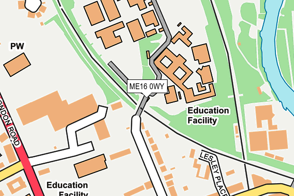
ME16 0WY is located in the Bridge electoral ward, within the local authority district of Maidstone and the English Parliamentary constituency of Maidstone and The Weald. The Sub Integrated Care Board (ICB) Location is NHS Kent and Medway ICB - 91Q and the police force is Kent. This postcode has been in use since May 2017.


GetTheData
Source: OS OpenMap – Local (Ordnance Survey)
Source: OS VectorMap District (Ordnance Survey)
Licence: Open Government Licence (requires attribution)
| Easting | 575237 |
| Northing | 156335 |
| Latitude | 51.279206 |
| Longitude | 0.511190 |
GetTheData
Source: Open Postcode Geo
Licence: Open Government Licence
| Country | England |
| Postcode District | ME16 |
| ➜ ME16 open data dashboard ➜ See where ME16 is on a map ➜ Where is Maidstone? | |
GetTheData
Source: Land Registry Price Paid Data
Licence: Open Government Licence
| Ward | Bridge |
| Constituency | Maidstone And The Weald |
GetTheData
Source: ONS Postcode Database
Licence: Open Government Licence
| December 2023 | Criminal damage and arson | On or near Lesley Place | 215m |
| October 2023 | Violence and sexual offences | On or near Lesley Place | 215m |
| October 2023 | Anti-social behaviour | On or near Lesley Place | 215m |
| ➜ Get more crime data in our Crime section | |||
GetTheData
Source: data.police.uk
Licence: Open Government Licence
| Maidstone Barracks Railway Station (Buckland Hill) | Maidstone | 290m |
| Somerfield Hospital (London Road) | Maidstone | 293m |
| London Road Retail Park (London Road) | Allington | 308m |
| London Road Retail Park (London Road) | Allington | 312m |
| Somerfield Hospital (London Road) | Maidstone | 330m |
| Maidstone Barracks Station | 0.3km |
| Maidstone East Station | 0.7km |
| Maidstone West Station | 1km |
GetTheData
Source: NaPTAN
Licence: Open Government Licence
GetTheData
Source: ONS Postcode Database
Licence: Open Government Licence


➜ Get more ratings from the Food Standards Agency
GetTheData
Source: Food Standards Agency
Licence: FSA terms & conditions
| Last Collection | |||
|---|---|---|---|
| Location | Mon-Fri | Sat | Distance |
| Buckland Hill | 17:30 | 12:30 | 314m |
| Maidstone Industrial Estate | 18:30 | 12:30 | 354m |
| Buckland Road | 17:30 | 12:30 | 377m |
GetTheData
Source: Dracos
Licence: Creative Commons Attribution-ShareAlike
| Facility | Distance |
|---|---|
| Maidstone Grammar School For Girls Buckland Road, Maidstone Grass Pitches, Sports Hall, Studio | 83m |
| Welcome Gym (Maidstone) Buckland Road, Maidstone Swimming Pool, Health and Fitness Gym, Studio | 111m |
| The Maplesden Noakes School Buckland Road, Great Buckland, Maidstone Sports Hall, Artificial Grass Pitch, Grass Pitches | 150m |
GetTheData
Source: Active Places
Licence: Open Government Licence
| School | Phase of Education | Distance |
|---|---|---|
| Maidstone Grammar School for Girls Buckland Road, Maidstone, ME16 0SF | Secondary | 83m |
| The Maplesden Noakes School Buckland Road, Maidstone, ME16 0TJ | Secondary | 150m |
| Brunswick House Primary School Leafy Lane, Maidstone, ME16 0QQ | Primary | 181m |
GetTheData
Source: Edubase
Licence: Open Government Licence
The below table lists the International Territorial Level (ITL) codes (formerly Nomenclature of Territorial Units for Statistics (NUTS) codes) and Local Administrative Units (LAU) codes for ME16 0WY:
| ITL 1 Code | Name |
|---|---|
| TLJ | South East (England) |
| ITL 2 Code | Name |
| TLJ4 | Kent |
| ITL 3 Code | Name |
| TLJ45 | Mid Kent |
| LAU 1 Code | Name |
| E07000110 | Maidstone |
GetTheData
Source: ONS Postcode Directory
Licence: Open Government Licence
The below table lists the Census Output Area (OA), Lower Layer Super Output Area (LSOA), and Middle Layer Super Output Area (MSOA) for ME16 0WY:
| Code | Name | |
|---|---|---|
| OA | E00170337 | |
| LSOA | E01024340 | Maidstone 006B |
| MSOA | E02005073 | Maidstone 006 |
GetTheData
Source: ONS Postcode Directory
Licence: Open Government Licence
| ME16 0YL | Brennan Mews | 124m |
| ME16 0SD | Buckland Road | 129m |
| ME16 0TU | The Mews | 173m |
| ME16 0LZ | Buckland Road | 179m |
| ME16 0ZA | Brunswick Mews | 193m |
| ME16 0TZ | Lesley Place | 227m |
| ME16 0SG | Buckland Hill | 233m |
| ME16 0GY | Buckland Road | 234m |
| ME16 0UB | Lesley Place | 250m |
| ME16 0UD | Lesley Place | 256m |
GetTheData
Source: Open Postcode Geo; Land Registry Price Paid Data
Licence: Open Government Licence