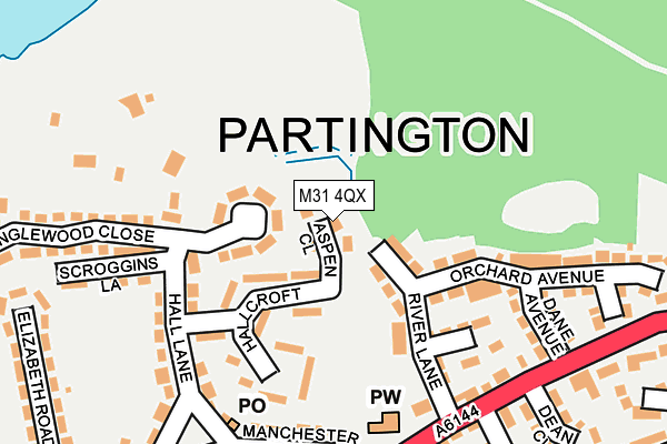
M31 4QX is located in the Bucklow-St Martins electoral ward, within the metropolitan district of Trafford and the English Parliamentary constituency of Stretford and Urmston. The Sub Integrated Care Board (ICB) Location is NHS Greater Manchester ICB - 02A and the police force is Greater Manchester. This postcode has been in use since March 2017.


GetTheData
Source: OS OpenMap – Local (Ordnance Survey)
Source: OS VectorMap District (Ordnance Survey)
Licence: Open Government Licence (requires attribution)
| Easting | 371785 |
| Northing | 391764 |
| Latitude | 53.421928 |
| Longitude | -2.426030 |
GetTheData
Source: Open Postcode Geo
Licence: Open Government Licence
| Country | England |
| Postcode District | M31 |
| ➜ M31 open data dashboard ➜ See where M31 is on a map ➜ Where is Partington? | |
GetTheData
Source: Land Registry Price Paid Data
Licence: Open Government Licence
| Ward | Bucklow-st Martins |
| Constituency | Stretford And Urmston |
GetTheData
Source: ONS Postcode Database
Licence: Open Government Licence
| Moss Lane (Sbd) (Moss Lane) | Partington | 248m |
| Manchester New Road/Central Road (M/Cr New Road) | Partington | 276m |
| Manchester New Road/Central Road (Mcr New Road) | Partington | 291m |
| Warburton Lane | Partington | 297m |
| Moss Ln (Nbd) (Moss Lane) | Partington | 326m |
| Irlam Station | 1.5km |
| Glazebrook Station | 2.3km |
| Flixton Station | 3.7km |
GetTheData
Source: NaPTAN
Licence: Open Government Licence
➜ Broadband speed and availability dashboard for M31 4QX
| Percentage of properties with Next Generation Access | 100.0% |
| Percentage of properties with Superfast Broadband | 100.0% |
| Percentage of properties with Ultrafast Broadband | 0.0% |
| Percentage of properties with Full Fibre Broadband | 0.0% |
Superfast Broadband is between 30Mbps and 300Mbps
Ultrafast Broadband is > 300Mbps
| Median download speed | 55.6Mbps |
| Average download speed | 53.4Mbps |
| Maximum download speed | 78.34Mbps |
| Median upload speed | 19.3Mbps |
| Average upload speed | 14.9Mbps |
| Maximum upload speed | 20.00Mbps |
| Percentage of properties unable to receive 2Mbps | 0.0% |
| Percentage of properties unable to receive 5Mbps | 0.0% |
| Percentage of properties unable to receive 10Mbps | 0.0% |
| Percentage of properties unable to receive 30Mbps | 0.0% |
➜ Broadband speed and availability dashboard for M31 4QX
GetTheData
Source: Ofcom
Licence: Ofcom Terms of Use (requires attribution)
GetTheData
Source: ONS Postcode Database
Licence: Open Government Licence


➜ Get more ratings from the Food Standards Agency
GetTheData
Source: Food Standards Agency
Licence: FSA terms & conditions
| Last Collection | |||
|---|---|---|---|
| Location | Mon-Fri | Sat | Distance |
| Partington P.o. | 17:30 | 12:00 | 208m |
| Outside Library Central Road | 17:30 | 11:30 | 367m |
| Broadway | 17:30 | 11:30 | 417m |
GetTheData
Source: Dracos
Licence: Creative Commons Attribution-ShareAlike
| Facility | Distance |
|---|---|
| Partington Central Academy Central Road, Partington, Manchester Artificial Grass Pitch, Sports Hall | 529m |
| Partington Pavilion & Moss View Playing Field Moss View Road, Partington, Manchester Grass Pitches, Sports Hall | 667m |
| Cadishead Park Liverpool Road, Cadishead, Irlam Grass Pitches | 758m |
GetTheData
Source: Active Places
Licence: Open Government Licence
| School | Phase of Education | Distance |
|---|---|---|
| Partington Central Academy Central Road, Partington, Urmston, Manchester, M31 4FL | Primary | 529m |
| Fairfield House School 57-59 Warburton Lane, Partington, Manchester, M31 4NL | Not applicable | 622m |
| Our Lady of Lourdes Catholic School Lock Lane, Partington, Manchester, M31 4PJ | Primary | 823m |
GetTheData
Source: Edubase
Licence: Open Government Licence
The below table lists the International Territorial Level (ITL) codes (formerly Nomenclature of Territorial Units for Statistics (NUTS) codes) and Local Administrative Units (LAU) codes for M31 4QX:
| ITL 1 Code | Name |
|---|---|
| TLD | North West (England) |
| ITL 2 Code | Name |
| TLD3 | Greater Manchester |
| ITL 3 Code | Name |
| TLD34 | Greater Manchester South West |
| LAU 1 Code | Name |
| E08000009 | Trafford |
GetTheData
Source: ONS Postcode Directory
Licence: Open Government Licence
The below table lists the Census Output Area (OA), Lower Layer Super Output Area (LSOA), and Middle Layer Super Output Area (MSOA) for M31 4QX:
| Code | Name | |
|---|---|---|
| OA | E00030931 | |
| LSOA | E01006104 | Trafford 017A |
| MSOA | E02001275 | Trafford 017 |
GetTheData
Source: ONS Postcode Directory
Licence: Open Government Licence
| M31 4QA | Derwent Close | 60m |
| M31 4DB | River Lane | 99m |
| M31 4ED | Hallcroft | 113m |
| M31 4DE | Queensway | 149m |
| M31 4PY | Hall Lane | 176m |
| M31 4FB | Manchester Road | 191m |
| M31 4GB | Dane Avenue | 195m |
| M31 4QH | Scroggins Lane | 204m |
| M31 4DL | Orchard Avenue | 204m |
| M31 4NZ | New William Close | 227m |
GetTheData
Source: Open Postcode Geo; Land Registry Price Paid Data
Licence: Open Government Licence