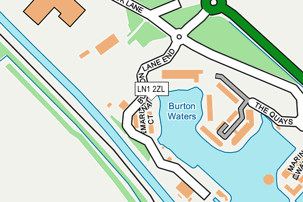
LN1 2ZL is located in the Saxilby electoral ward, within the local authority district of West Lindsey and the English Parliamentary constituency of Gainsborough. The Sub Integrated Care Board (ICB) Location is NHS Lincolnshire ICB - 71E and the police force is Lincolnshire. This postcode has been in use since March 2017.


GetTheData
Source: OS OpenMap – Local (Ordnance Survey)
Source: OS VectorMap District (Ordnance Survey)
Licence: Open Government Licence (requires attribution)
| Easting | 493479 |
| Northing | 373498 |
| Latitude | 53.250296 |
| Longitude | -0.600431 |
GetTheData
Source: Open Postcode Geo
Licence: Open Government Licence
| Country | England |
| Postcode District | LN1 |
➜ See where LN1 is on a map ➜ Where is Burton Waters? | |
GetTheData
Source: Land Registry Price Paid Data
Licence: Open Government Licence
| Ward | Saxilby |
| Constituency | Gainsborough |
GetTheData
Source: ONS Postcode Database
Licence: Open Government Licence
| Burton Waters (Burton Lane End) | Burton | 221m |
| The Landings (Marine Walk) | Burton | 285m |
| Saxilby Station | 4.6km |
| Lincoln Central Station | 4.9km |
GetTheData
Source: NaPTAN
Licence: Open Government Licence
| Percentage of properties with Next Generation Access | 100.0% |
| Percentage of properties with Superfast Broadband | 100.0% |
| Percentage of properties with Ultrafast Broadband | 100.0% |
| Percentage of properties with Full Fibre Broadband | 100.0% |
Superfast Broadband is between 30Mbps and 300Mbps
Ultrafast Broadband is > 300Mbps
| Median download speed | 100.0Mbps |
| Average download speed | 166.7Mbps |
| Maximum download speed | 350.00Mbps |
Ofcom does not currently provide upload speed data for LN1 2ZL. This is because there are less than four broadband connections in this postcode.
| Percentage of properties unable to receive 2Mbps | 0.0% |
| Percentage of properties unable to receive 5Mbps | 0.0% |
| Percentage of properties unable to receive 10Mbps | 0.0% |
| Percentage of properties unable to receive 30Mbps | 0.0% |
GetTheData
Source: Ofcom
Licence: Ofcom Terms of Use (requires attribution)
GetTheData
Source: ONS Postcode Database
Licence: Open Government Licence


➜ Get more ratings from the Food Standards Agency
GetTheData
Source: Food Standards Agency
Licence: FSA terms & conditions
| Last Collection | |||
|---|---|---|---|
| Location | Mon-Fri | Sat | Distance |
| Odder | 17:15 | 12:45 | 1,659m |
| Carholme Road | 18:30 | 11:30 | 2,843m |
| Hillcroft | 16:30 | 11:30 | 3,468m |
GetTheData
Source: Dracos
Licence: Creative Commons Attribution-ShareAlike
| Risk of LN1 2ZL flooding from rivers and sea | High |
| ➜ LN1 2ZL flood map | |
GetTheData
Source: Open Flood Risk by Postcode
Licence: Open Government Licence
The below table lists the International Territorial Level (ITL) codes (formerly Nomenclature of Territorial Units for Statistics (NUTS) codes) and Local Administrative Units (LAU) codes for LN1 2ZL:
| ITL 1 Code | Name |
|---|---|
| TLF | East Midlands (England) |
| ITL 2 Code | Name |
| TLF3 | Lincolnshire |
| ITL 3 Code | Name |
| TLF30 | Lincolnshire CC |
| LAU 1 Code | Name |
| E07000142 | West Lindsey |
GetTheData
Source: ONS Postcode Directory
Licence: Open Government Licence
The below table lists the Census Output Area (OA), Lower Layer Super Output Area (LSOA), and Middle Layer Super Output Area (MSOA) for LN1 2ZL:
| Code | Name | |
|---|---|---|
| OA | E00168574 | |
| LSOA | E01026397 | West Lindsey 009B |
| MSOA | E02005500 | West Lindsey 009 |
GetTheData
Source: ONS Postcode Directory
Licence: Open Government Licence
| LN1 2UA | Burton Lane End | 66m |
| LN1 2XG | The Quays | 156m |
| LN1 2WN | 209m | |
| LN1 2TU | The Landings | 294m |
| LN1 2TS | Marine Walk | 301m |
| LN1 2GG | Ellisons Quay | 387m |
| LN1 2UZ | Park Lane | 405m |
| LN1 2WP | Park Lane | 442m |
| LN1 2LW | Marine Approach | 489m |
| LN1 2WQ | The Moorings | 509m |
GetTheData
Source: Open Postcode Geo; Land Registry Price Paid Data
Licence: Open Government Licence