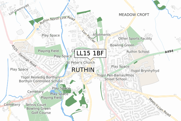
LL15 1BF is located in the Moel Famau electoral ward, within the unitary authority of Denbighshire and the Welsh Parliamentary constituency of Clwyd West. The Local Health Board is Betsi Cadwaladr University and the police force is North Wales. This postcode has been in use since April 2020.


GetTheData
Source: OS Open Zoomstack (Ordnance Survey)
Licence: Open Government Licence (requires attribution)
Attribution: Contains OS data © Crown copyright and database right 2024
Source: Open Postcode Geo
Licence: Open Government Licence (requires attribution)
Attribution: Contains OS data © Crown copyright and database right 2024; Contains Royal Mail data © Royal Mail copyright and database right 2024; Source: Office for National Statistics licensed under the Open Government Licence v.3.0
| Easting | 314145 |
| Northing | 359733 |
| Latitude | 53.127838 |
| Longitude | -3.284549 |
GetTheData
Source: Open Postcode Geo
Licence: Open Government Licence
| Country | Wales |
| Postcode District | LL15 |
| ➜ LL15 open data dashboard ➜ See where LL15 is on a map ➜ Where is Llanbedr-Dyffryn-Clwyd? | |
GetTheData
Source: Land Registry Price Paid Data
Licence: Open Government Licence
| Ward | Moel Famau |
| Constituency | Clwyd West |
GetTheData
Source: ONS Postcode Database
Licence: Open Government Licence
| May 2022 | Public order | On or near Maes Derwen | 139m |
| May 2022 | Anti-social behaviour | On or near Maes Derwen | 139m |
| May 2022 | Anti-social behaviour | On or near Maes Derwen | 139m |
| ➜ Get more crime data in our Crime section | |||
GetTheData
Source: data.police.uk
Licence: Open Government Licence
| Maes Derwen (B5429) | Llanbedr Dyffryn Clwyd | 64m |
| Cae Delyn (B5429) | Llanbedr Dyffryn Clwyd | 319m |
| Griffin Hotel (B5429) | Llanbedr Dyffryn Clwyd | 539m |
| Tan-yr-unto (A494) | Llanbedr Dyffryn Clwyd | 892m |
| Smithy (A494 Mold Road) | Ruthin | 923m |
GetTheData
Source: NaPTAN
Licence: Open Government Licence
GetTheData
Source: ONS Postcode Database
Licence: Open Government Licence


➜ Get more ratings from the Food Standards Agency
GetTheData
Source: Food Standards Agency
Licence: FSA terms & conditions
| Last Collection | |||
|---|---|---|---|
| Location | Mon-Fri | Sat | Distance |
| Llanbedr Post Office | 15:45 | 09:45 | 476m |
| Mold Road | 17:15 | 10:45 | 1,542m |
| Lon Parcwr | 17:15 | 10:00 | 1,970m |
GetTheData
Source: Dracos
Licence: Creative Commons Attribution-ShareAlike
| School | Phase of Education | Distance |
|---|---|---|
| Ysgol Reoledig Llanbedr Llanbedr, Ruthin, Denbighshire, LL15 1SU | Not applicable | 502m |
| Ruthin School Mold Road, Ruthin, Denbighshire, LL15 1EE | Not applicable | 1.6km |
| Ysgol Brynhyfryd Mold Road, Ruthin, Denbighshire, LL15 1EG | Not applicable | 1.7km |
GetTheData
Source: Edubase
Licence: Open Government Licence
The below table lists the International Territorial Level (ITL) codes (formerly Nomenclature of Territorial Units for Statistics (NUTS) codes) and Local Administrative Units (LAU) codes for LL15 1BF:
| ITL 1 Code | Name |
|---|---|
| TLL | Wales |
| ITL 2 Code | Name |
| TLL1 | West Wales and The Valleys |
| ITL 3 Code | Name |
| TLL13 | Conwy and Denbighshire |
| LAU 1 Code | Name |
| W06000004 | Denbighshire |
GetTheData
Source: ONS Postcode Directory
Licence: Open Government Licence
The below table lists the Census Output Area (OA), Lower Layer Super Output Area (LSOA), and Middle Layer Super Output Area (MSOA) for LL15 1BF:
| Code | Name | |
|---|---|---|
| OA | W00001089 | |
| LSOA | W01000204 | Denbighshire 013B |
| MSOA | W02000054 | Denbighshire 013 |
GetTheData
Source: ONS Postcode Directory
Licence: Open Government Licence
| LL15 1ST | Maes Derwen | 131m |
| LL15 1BQ | Troed Y Fenlli | 283m |
| LL15 1YR | Maes Celyn | 309m |
| LL15 1SS | 328m | |
| LL15 1UP | 416m | |
| LL15 1UU | 577m | |
| LL15 1UY | Y Llys | 601m |
| LL15 1SU | 628m | |
| LL15 1YD | 639m | |
| LL15 1US | Lon Cae Glas | 701m |
GetTheData
Source: Open Postcode Geo; Land Registry Price Paid Data
Licence: Open Government Licence