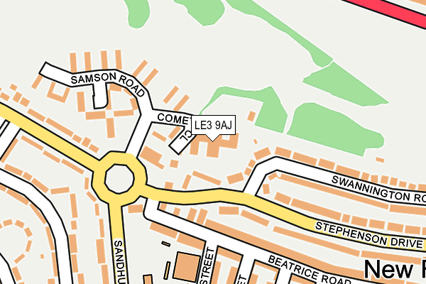
LE3 9AJ is located in the Fosse electoral ward, within the unitary authority of Leicester and the English Parliamentary constituency of Leicester West. The Sub Integrated Care Board (ICB) Location is NHS Leicester, Leicestershire and Rutland ICB - 04C and the police force is Leicestershire. This postcode has been in use since June 2017.


GetTheData
Source: OS OpenMap – Local (Ordnance Survey)
Source: OS VectorMap District (Ordnance Survey)
Licence: Open Government Licence (requires attribution)
| Easting | 456991 |
| Northing | 305380 |
| Latitude | 52.643194 |
| Longitude | -1.159159 |
GetTheData
Source: Open Postcode Geo
Licence: Open Government Licence
| Country | England |
| Postcode District | LE3 |
| ➜ LE3 open data dashboard ➜ See where LE3 is on a map ➜ Where is Leicester? | |
GetTheData
Source: Land Registry Price Paid Data
Licence: Open Government Licence
| Ward | Fosse |
| Constituency | Leicester West |
GetTheData
Source: ONS Postcode Database
Licence: Open Government Licence
| January 2024 | Violence and sexual offences | On or near Blissett Road | 469m |
| December 2023 | Criminal damage and arson | On or near Blissett Road | 469m |
| December 2023 | Violence and sexual offences | On or near Blissett Road | 469m |
| ➜ Get more crime data in our Crime section | |||
GetTheData
Source: data.police.uk
Licence: Open Government Licence
| Samson Road (Stephenson Drive) | Newfoundpool | 98m |
| Samson Road (Stephenson Drive) | Newfoundpool | 105m |
| Swannington Road (Stephenson Drive) | Newfoundpool | 138m |
| Swannington Road (Stephenson Drive) | Newfoundpool | 160m |
| Bloxham Road (Pindar Road) | New Parks | 235m |
| Leicester Station | 2.6km |
GetTheData
Source: NaPTAN
Licence: Open Government Licence
➜ Broadband speed and availability dashboard for LE3 9AJ
| Percentage of properties with Next Generation Access | 100.0% |
| Percentage of properties with Superfast Broadband | 100.0% |
| Percentage of properties with Ultrafast Broadband | 100.0% |
| Percentage of properties with Full Fibre Broadband | 0.0% |
Superfast Broadband is between 30Mbps and 300Mbps
Ultrafast Broadband is > 300Mbps
| Median download speed | 15.1Mbps |
| Average download speed | 14.9Mbps |
| Maximum download speed | 50.00Mbps |
| Median upload speed | 3.4Mbps |
| Average upload speed | 2.9Mbps |
| Maximum upload speed | 5.26Mbps |
| Percentage of properties unable to receive 2Mbps | 0.0% |
| Percentage of properties unable to receive 5Mbps | 0.0% |
| Percentage of properties unable to receive 10Mbps | 0.0% |
| Percentage of properties unable to receive 30Mbps | 0.0% |
➜ Broadband speed and availability dashboard for LE3 9AJ
GetTheData
Source: Ofcom
Licence: Ofcom Terms of Use (requires attribution)
GetTheData
Source: ONS Postcode Database
Licence: Open Government Licence


➜ Get more ratings from the Food Standards Agency
GetTheData
Source: Food Standards Agency
Licence: FSA terms & conditions
| Last Collection | |||
|---|---|---|---|
| Location | Mon-Fri | Sat | Distance |
| Comet Close | 17:00 | 12:00 | 83m |
| Bateman Road | 17:00 | 12:00 | 371m |
| Lindfield Road | 17:00 | 12:00 | 641m |
GetTheData
Source: Dracos
Licence: Creative Commons Attribution-ShareAlike
| Facility | Distance |
|---|---|
| Stokes Wood Primary School Blackett Avenue, Leicester Grass Pitches | 599m |
| English Martyrs Catholic School Anstey Lane, Leicester Grass Pitches, Sports Hall, Studio, Outdoor Tennis Courts | 783m |
| Westfields Tennis Club Eastfield Road, Leicester Outdoor Tennis Courts | 1km |
GetTheData
Source: Active Places
Licence: Open Government Licence
| School | Phase of Education | Distance |
|---|---|---|
| Inglehurst Junior School Ingle Street, Leicester, LE3 9FS | Primary | 177m |
| Inglehurst Infant School Ingle Street, Leicester, LE3 9FS | Primary | 239m |
| Parks Primary School New Parks Crescent, Leicester, LE3 9NZ | Primary | 542m |
GetTheData
Source: Edubase
Licence: Open Government Licence
The below table lists the International Territorial Level (ITL) codes (formerly Nomenclature of Territorial Units for Statistics (NUTS) codes) and Local Administrative Units (LAU) codes for LE3 9AJ:
| ITL 1 Code | Name |
|---|---|
| TLF | East Midlands (England) |
| ITL 2 Code | Name |
| TLF2 | Leicestershire, Rutland and Northamptonshire |
| ITL 3 Code | Name |
| TLF21 | Leicester |
| LAU 1 Code | Name |
| E06000016 | Leicester |
GetTheData
Source: ONS Postcode Directory
Licence: Open Government Licence
The below table lists the Census Output Area (OA), Lower Layer Super Output Area (LSOA), and Middle Layer Super Output Area (MSOA) for LE3 9AJ:
| Code | Name | |
|---|---|---|
| OA | E00169467 | |
| LSOA | E01013725 | Leicester 012C |
| MSOA | E02002838 | Leicester 012 |
GetTheData
Source: ONS Postcode Directory
Licence: Open Government Licence
| LE3 9FN | Beatrice Road | 121m |
| LE3 9FG | Beatrice Road | 144m |
| LE3 9FL | Beatrice Road | 193m |
| LE3 9RH | Pindar Road | 210m |
| LE3 9FS | Ingle Street | 218m |
| LE3 9FF | Beatrice Road | 219m |
| LE3 9AA | Fosse Lane | 238m |
| LE3 9RW | Sandhurst Road | 239m |
| LE3 9HJ | Biddle Road | 246m |
| LE3 9AG | Swannington Road | 250m |
GetTheData
Source: Open Postcode Geo; Land Registry Price Paid Data
Licence: Open Government Licence