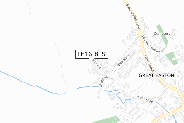
LE16 8TS maps, stats, and open data
- Home
- Postcode
- LE
- LE16
- LE16 8
LE16 8TS is located in the Nevill electoral ward, within the local authority district of Harborough and the English Parliamentary constituency of Rutland and Melton. The Sub Integrated Care Board (ICB) Location is NHS Leicester, Leicestershire and Rutland ICB - 03W and the police force is Leicestershire. This postcode has been in use since August 2017.
LE16 8TS maps


Source: OS Open Zoomstack (Ordnance Survey)
Licence: Open Government Licence (requires attribution)
Attribution: Contains OS data © Crown copyright and database right 2025
Source: Open Postcode GeoLicence: Open Government Licence (requires attribution)
Attribution: Contains OS data © Crown copyright and database right 2025; Contains Royal Mail data © Royal Mail copyright and database right 2025; Source: Office for National Statistics licensed under the Open Government Licence v.3.0
LE16 8TS geodata
| Easting | 484450 |
| Northing | 293173 |
| Latitude | 52.529908 |
| Longitude | -0.756533 |
Where is LE16 8TS?
| Country | England |
| Postcode District | LE16 |
Politics
| Ward | Nevill |
|---|
| Constituency | Rutland And Melton |
|---|
Transport
Nearest bus stops to LE16 8TS
| Broadgate (High Street) | Great Easton | 284m |
| Church Bank (High Street) | Great Easton | 535m |
| Bringhurst Turn (Great Easton Road) | Bringhurst | 687m |
| Bringhurst Turn (Great Easton Road) | Bringhurst | 691m |
| Telephone Box (Great Easton Road) | Bringhurst | 991m |
Nearest railway stations to LE16 8TS
Broadband
Broadband access in LE16 8TS (2020 data)
| Percentage of properties with Next Generation Access | 100.0% |
| Percentage of properties with Superfast Broadband | 100.0% |
| Percentage of properties with Ultrafast Broadband | 0.0% |
| Percentage of properties with Full Fibre Broadband | 0.0% |
Superfast Broadband is between 30Mbps and 300Mbps
Ultrafast Broadband is > 300Mbps
Broadband speed in LE16 8TS (2019 data)
Download
| Median download speed | 39.0Mbps |
| Average download speed | 36.6Mbps |
| Maximum download speed | 56.45Mbps |
Upload
| Median upload speed | 7.3Mbps |
| Average upload speed | 6.9Mbps |
| Maximum upload speed | 9.82Mbps |
Broadband limitations in LE16 8TS (2020 data)
| Percentage of properties unable to receive 2Mbps | 0.0% |
| Percentage of properties unable to receive 5Mbps | 0.0% |
| Percentage of properties unable to receive 10Mbps | 0.0% |
| Percentage of properties unable to receive 30Mbps | 0.0% |
Deprivation
18.3% of English postcodes are less deprived than
LE16 8TS:
Food Standards Agency
Three nearest food hygiene ratings to LE16 8TS (metres)
411 Fun Club
Philip Johnson & Daughters
Sharon Wright Slimming World
➜ Get more ratings from the Food Standards Agency
Nearest post box to LE16 8TS
| | Last Collection | |
|---|
| Location | Mon-Fri | Sat | Distance |
|---|
| Cottingham Rso | 16:45 | 10:00 | 3,005m |
| Shire Road | 17:00 | 11:15 | 3,985m |
| Tanfield Grove | 17:00 | 11:15 | 5,098m |
LE16 8TS ITL and LE16 8TS LAU
The below table lists the International Territorial Level (ITL) codes (formerly Nomenclature of Territorial Units for Statistics (NUTS) codes) and Local Administrative Units (LAU) codes for LE16 8TS:
| ITL 1 Code | Name |
|---|
| TLF | East Midlands (England) |
| ITL 2 Code | Name |
|---|
| TLF2 | Leicestershire, Rutland and Northamptonshire |
| ITL 3 Code | Name |
|---|
| TLF22 | Leicestershire CC and Rutland |
| LAU 1 Code | Name |
|---|
| E07000131 | Harborough |
LE16 8TS census areas
The below table lists the Census Output Area (OA), Lower Layer Super Output Area (LSOA), and Middle Layer Super Output Area (MSOA) for LE16 8TS:
| Code | Name |
|---|
| OA | E00130953 | |
|---|
| LSOA | E01025809 | Harborough 002B |
|---|
| MSOA | E02005368 | Harborough 002 |
|---|
Nearest postcodes to LE16 8TS


