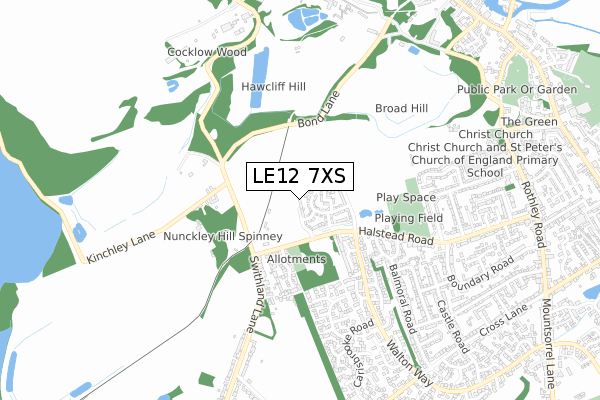
LE12 7XS is located in the Mountsorrel electoral ward, within the local authority district of Charnwood and the English Parliamentary constituency of Charnwood. The Sub Integrated Care Board (ICB) Location is NHS Leicester, Leicestershire and Rutland ICB - 04V and the police force is Leicestershire. This postcode has been in use since December 2019.


GetTheData
Source: OS Open Zoomstack (Ordnance Survey)
Licence: Open Government Licence (requires attribution)
Attribution: Contains OS data © Crown copyright and database right 2024
Source: Open Postcode Geo
Licence: Open Government Licence (requires attribution)
Attribution: Contains OS data © Crown copyright and database right 2024; Contains Royal Mail data © Royal Mail copyright and database right 2024; Source: Office for National Statistics licensed under the Open Government Licence v.3.0
| Easting | 457288 |
| Northing | 314445 |
| Latitude | 52.724646 |
| Longitude | -1.153196 |
GetTheData
Source: Open Postcode Geo
Licence: Open Government Licence
| Country | England |
| Postcode District | LE12 |
| ➜ LE12 open data dashboard ➜ See where LE12 is on a map ➜ Where is Mountsorrel? | |
GetTheData
Source: Land Registry Price Paid Data
Licence: Open Government Licence
| Ward | Mountsorrel |
| Constituency | Charnwood |
GetTheData
Source: ONS Postcode Database
Licence: Open Government Licence
12, WALTERS CLOSE, MOUNTSORREL, LOUGHBOROUGH, LE12 7XS 2021 29 JAN £284,950 |
10, WALTERS CLOSE, MOUNTSORREL, LOUGHBOROUGH, LE12 7XS 2020 27 NOV £284,950 |
8, WALTERS CLOSE, MOUNTSORREL, LOUGHBOROUGH, LE12 7XS 2020 27 NOV £284,950 |
14, WALTERS CLOSE, MOUNTSORREL, LOUGHBOROUGH, LE12 7XS 2020 27 NOV £284,950 |
16, WALTERS CLOSE, MOUNTSORREL, LOUGHBOROUGH, LE12 7XS 2020 30 OCT £289,950 |
1, WALTERS CLOSE, MOUNTSORREL, LOUGHBOROUGH, LE12 7XS 2019 18 DEC £272,950 |
3, WALTERS CLOSE, MOUNTSORREL, LOUGHBOROUGH, LE12 7XS 2019 18 DEC £279,950 |
7, WALTERS CLOSE, MOUNTSORREL, LOUGHBOROUGH, LE12 7XS 2019 29 NOV £399,950 |
5, WALTERS CLOSE, MOUNTSORREL, LOUGHBOROUGH, LE12 7XS 2019 29 NOV £459,950 |
GetTheData
Source: HM Land Registry Price Paid Data
Licence: Contains HM Land Registry data © Crown copyright and database right 2024. This data is licensed under the Open Government Licence v3.0.
| June 2022 | Violence and sexual offences | On or near Edinburgh Way | 326m |
| June 2022 | Burglary | On or near Fort Road | 460m |
| June 2022 | Anti-social behaviour | On or near Sports/Recreation Area | 464m |
| ➜ Get more crime data in our Crime section | |||
GetTheData
Source: data.police.uk
Licence: Open Government Licence
| Church Hill Road (Rothley Road) | Mountsorrel | 900m |
| Church Hill Road (Rothley Road) | Mountsorrel | 917m |
| Danvers Road | Mountsorrel | 980m |
| Danvers Road (Rothley Road) | Mountsorrel | 995m |
| Bond Lane (Loughborough Road) | Mountsorrel | 1,025m |
| Barrow upon Soar Station | 2.8km |
| Sileby Station | 3km |
| Syston Station | 5.9km |
GetTheData
Source: NaPTAN
Licence: Open Government Licence
GetTheData
Source: ONS Postcode Database
Licence: Open Government Licence


➜ Get more ratings from the Food Standards Agency
GetTheData
Source: Food Standards Agency
Licence: FSA terms & conditions
| Last Collection | |||
|---|---|---|---|
| Location | Mon-Fri | Sat | Distance |
| Halstead Road | 16:45 | 10:45 | 399m |
| Cross Lane | 16:40 | 10:45 | 874m |
| Rothley Road | 16:45 | 10:45 | 923m |
GetTheData
Source: Dracos
Licence: Creative Commons Attribution-ShareAlike
| Facility | Distance |
|---|---|
| Halstead Road Playing Fields Halstead Road, Mountsorrel Grass Pitches | 453m |
| Mountsorrel Memorial Playing Field Little Lane, Mountsorrel Grass Pitches | 1.2km |
| Soar Valley Leisure Centre Kingfisher Road, Mountsorrel, Loughborough Sports Hall, Swimming Pool, Health and Fitness Gym, Artificial Grass Pitch, Studio | 1.2km |
GetTheData
Source: Active Places
Licence: Open Government Licence
| School | Phase of Education | Distance |
|---|---|---|
| Christ Church & Saint Peter's Cofe Primary School 8 Rothley Road, Mountsorrel, Loughborough, LE12 7JU | Primary | 847m |
| Homefield College 217 Loughborough Road, Mountsorrel, LE12 7AR | Not applicable | 1.2km |
| Swithland St Leonard's Church of England Primary School Main Street, Swithland, Loughborough, LE12 8TQ | Primary | 2.5km |
GetTheData
Source: Edubase
Licence: Open Government Licence
The below table lists the International Territorial Level (ITL) codes (formerly Nomenclature of Territorial Units for Statistics (NUTS) codes) and Local Administrative Units (LAU) codes for LE12 7XS:
| ITL 1 Code | Name |
|---|---|
| TLF | East Midlands (England) |
| ITL 2 Code | Name |
| TLF2 | Leicestershire, Rutland and Northamptonshire |
| ITL 3 Code | Name |
| TLF22 | Leicestershire CC and Rutland |
| LAU 1 Code | Name |
| E07000130 | Charnwood |
GetTheData
Source: ONS Postcode Directory
Licence: Open Government Licence
The below table lists the Census Output Area (OA), Lower Layer Super Output Area (LSOA), and Middle Layer Super Output Area (MSOA) for LE12 7XS:
| Code | Name | |
|---|---|---|
| OA | E00130523 | |
| LSOA | E01025728 | Charnwood 014C |
| MSOA | E02005358 | Charnwood 014 |
GetTheData
Source: ONS Postcode Directory
Licence: Open Government Licence
| LE12 7HG | Halstead Road | 263m |
| LE12 7HE | Halstead Road | 328m |
| LE12 7FU | Edinburgh Way | 332m |
| LE12 7ST | Willow Grove | 345m |
| LE12 7SN | The Osiers | 374m |
| LE12 7EJ | Balmoral Road | 402m |
| LE12 7UQ | Rosslyn Avenue | 437m |
| LE12 7EX | Conway Road | 437m |
| LE7 7SJ | Swithland Lane | 448m |
| LE12 7GH | Kenilworth Close | 449m |
GetTheData
Source: Open Postcode Geo; Land Registry Price Paid Data
Licence: Open Government Licence