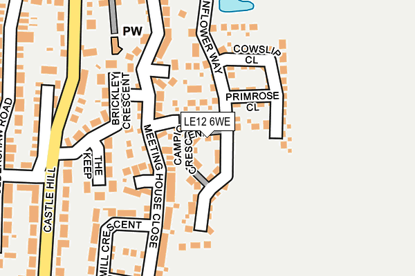
LE12 6WE is located in the Leake electoral ward, within the local authority district of Rushcliffe and the English Parliamentary constituency of Rushcliffe. The Sub Integrated Care Board (ICB) Location is NHS Nottingham and Nottinghamshire ICB - 52R and the police force is Nottinghamshire. This postcode has been in use since April 2017.


GetTheData
Source: OS OpenMap – Local (Ordnance Survey)
Source: OS VectorMap District (Ordnance Survey)
Licence: Open Government Licence (requires attribution)
| Easting | 455971 |
| Northing | 326036 |
| Latitude | 52.828971 |
| Longitude | -1.170719 |
GetTheData
Source: Open Postcode Geo
Licence: Open Government Licence
| Country | England |
| Postcode District | LE12 |
➜ See where LE12 is on a map ➜ Where is East Leake? | |
GetTheData
Source: Land Registry Price Paid Data
Licence: Open Government Licence
| Ward | Leake |
| Constituency | Rushcliffe |
GetTheData
Source: ONS Postcode Database
Licence: Open Government Licence
2022 21 DEC £455,000 |
2022 21 DEC £335,000 |
2021 29 JAN £410,000 |
2017 1 DEC £324,995 |
8, CAMPION CRESCENT, EAST LEAKE, LOUGHBOROUGH, LE12 6WE 2017 28 SEP £319,995 |
2017 15 SEP £259,995 |
13, CAMPION CRESCENT, EAST LEAKE, LOUGHBOROUGH, LE12 6WE 2017 5 SEP £375,995 |
9, CAMPION CRESCENT, EAST LEAKE, LOUGHBOROUGH, LE12 6WE 2017 30 JUN £372,995 |
2017 29 JUN £372,995 |
6, CAMPION CRESCENT, EAST LEAKE, LOUGHBOROUGH, LE12 6WE 2017 28 JUN £541,995 |
GetTheData
Source: HM Land Registry Price Paid Data
Licence: Contains HM Land Registry data © Crown copyright and database right 2025. This data is licensed under the Open Government Licence v3.0.
| Castle Hill (Costock Road) | East Leake | 311m |
| Castle Hill (Costock Road) | East Leake | 315m |
| Shops (Gotham Road) | East Leake | 536m |
| Shops (Gotham Road) | East Leake | 560m |
| East Leake Academy Bus Park (Lantern Lane) | East Leake | 722m |
GetTheData
Source: NaPTAN
Licence: Open Government Licence
| Percentage of properties with Next Generation Access | 92.3% |
| Percentage of properties with Superfast Broadband | 92.3% |
| Percentage of properties with Ultrafast Broadband | 92.3% |
| Percentage of properties with Full Fibre Broadband | 0.0% |
Superfast Broadband is between 30Mbps and 300Mbps
Ultrafast Broadband is > 300Mbps
| Median download speed | 100.0Mbps |
| Average download speed | 126.0Mbps |
| Maximum download speed | 200.00Mbps |
| Median upload speed | 1.2Mbps |
| Average upload speed | 1.2Mbps |
| Maximum upload speed | 1.26Mbps |
| Percentage of properties unable to receive 2Mbps | 0.0% |
| Percentage of properties unable to receive 5Mbps | 0.0% |
| Percentage of properties unable to receive 10Mbps | 0.0% |
| Percentage of properties unable to receive 30Mbps | 7.7% |
GetTheData
Source: Ofcom
Licence: Ofcom Terms of Use (requires attribution)
GetTheData
Source: ONS Postcode Database
Licence: Open Government Licence


➜ Get more ratings from the Food Standards Agency
GetTheData
Source: Food Standards Agency
Licence: FSA terms & conditions
| Last Collection | |||
|---|---|---|---|
| Location | Mon-Fri | Sat | Distance |
| Barne End | 17:00 | 10:00 | 289m |
| East Leake Post Office | 17:00 | 10:30 | 475m |
| Stonebridge Drive | 17:00 | 10:00 | 712m |
GetTheData
Source: Dracos
Licence: Creative Commons Attribution-ShareAlike
The below table lists the International Territorial Level (ITL) codes (formerly Nomenclature of Territorial Units for Statistics (NUTS) codes) and Local Administrative Units (LAU) codes for LE12 6WE:
| ITL 1 Code | Name |
|---|---|
| TLF | East Midlands (England) |
| ITL 2 Code | Name |
| TLF1 | Derbyshire and Nottinghamshire |
| ITL 3 Code | Name |
| TLF16 | South Nottinghamshire |
| LAU 1 Code | Name |
| E07000176 | Rushcliffe |
GetTheData
Source: ONS Postcode Directory
Licence: Open Government Licence
The below table lists the Census Output Area (OA), Lower Layer Super Output Area (LSOA), and Middle Layer Super Output Area (MSOA) for LE12 6WE:
| Code | Name | |
|---|---|---|
| OA | E00144648 | |
| LSOA | E01028389 | Rushcliffe 015B |
| MSOA | E02005920 | Rushcliffe 015 |
GetTheData
Source: ONS Postcode Directory
Licence: Open Government Licence
| LE12 6HY | Meeting House Close | 66m |
| LE12 6TG | Cornflour Way | 79m |
| LE12 6ND | The Keep | 128m |
| LE12 6LT | Brickley Crescent | 145m |
| LE12 6NY | Windmill Crescent | 196m |
| LE12 6LU | Castlehill | 201m |
| LE12 6LX | Castlehill | 232m |
| LE12 6NF | Oldershaw Road | 257m |
| LE12 6LY | Costock Road | 286m |
| LE12 6NE | Mill Lane | 291m |
GetTheData
Source: Open Postcode Geo; Land Registry Price Paid Data
Licence: Open Government Licence