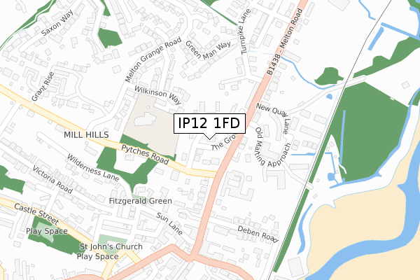
IP12 1FD maps, stats, and open data
IP12 1FD is located in the Melton electoral ward, within the local authority district of East Suffolk and the English Parliamentary constituency of Suffolk Coastal. The Sub Integrated Care Board (ICB) Location is NHS Suffolk and North East Essex ICB - 06L and the police force is Suffolk. This postcode has been in use since August 2017.
IP12 1FD maps


Licence: Open Government Licence (requires attribution)
Attribution: Contains OS data © Crown copyright and database right 2025
Source: Open Postcode Geo
Licence: Open Government Licence (requires attribution)
Attribution: Contains OS data © Crown copyright and database right 2025; Contains Royal Mail data © Royal Mail copyright and database right 2025; Source: Office for National Statistics licensed under the Open Government Licence v.3.0
IP12 1FD geodata
| Easting | 627631 |
| Northing | 249515 |
| Latitude | 52.097134 |
| Longitude | 1.321962 |
Where is IP12 1FD?
| Country | England |
| Postcode District | IP12 |
Politics
| Ward | Melton |
|---|---|
| Constituency | Suffolk Coastal |
House Prices
Sales of detached houses in IP12 1FD
2024 31 OCT £1,445,000 |
2023 10 FEB £1,750,000 |
2020 19 NOV £950,000 |
2020 19 NOV £1,246,375 |
2020 16 NOV £980,000 |
2018 5 DEC £975,000 |
2018 18 OCT £1,400,000 |
2018 26 JUL £1,225,000 |
PALOMAR HOUSE, THE GROVE, MELTON, WOODBRIDGE, IP12 1FD 2017 21 DEC £1,300,000 |
2017 30 OCT £899,950 |
Licence: Contains HM Land Registry data © Crown copyright and database right 2025. This data is licensed under the Open Government Licence v3.0.
Transport
Nearest bus stops to IP12 1FD
| The Grove (Pytchers Road) | Woodbridge | 110m |
| Council Offices (Melton Hill) | Woodbridge | 113m |
| The Grove (Pytchers Road) | Woodbridge | 119m |
| Council Offices (Melton Hill) | Woodbridge | 125m |
| Church (St Johns Street) | Woodbridge | 361m |
Nearest railway stations to IP12 1FD
| Woodbridge Station | 0.8km |
| Melton (Suffolk) Station | 1.4km |
Broadband
Broadband access in IP12 1FD (2020 data)
| Percentage of properties with Next Generation Access | 100.0% |
| Percentage of properties with Superfast Broadband | 100.0% |
| Percentage of properties with Ultrafast Broadband | 0.0% |
| Percentage of properties with Full Fibre Broadband | 0.0% |
Superfast Broadband is between 30Mbps and 300Mbps
Ultrafast Broadband is > 300Mbps
Broadband speed in IP12 1FD (2019 data)
Download
| Median download speed | 47.0Mbps |
| Average download speed | 44.1Mbps |
| Maximum download speed | 74.94Mbps |
Upload
| Median upload speed | 9.9Mbps |
| Average upload speed | 8.7Mbps |
| Maximum upload speed | 20.00Mbps |
Broadband limitations in IP12 1FD (2020 data)
| Percentage of properties unable to receive 2Mbps | 0.0% |
| Percentage of properties unable to receive 5Mbps | 0.0% |
| Percentage of properties unable to receive 10Mbps | 0.0% |
| Percentage of properties unable to receive 30Mbps | 0.0% |
Deprivation
39.2% of English postcodes are less deprived than IP12 1FD:Food Standards Agency
Three nearest food hygiene ratings to IP12 1FD (metres)


➜ Get more ratings from the Food Standards Agency
Nearest post box to IP12 1FD
| Last Collection | |||
|---|---|---|---|
| Location | Mon-Fri | Sat | Distance |
| St. John St | 17:30 | 11:30 | 265m |
| Melton Road | 17:30 | 12:00 | 419m |
| Library New Street | 17:30 | 11:30 | 428m |
IP12 1FD ITL and IP12 1FD LAU
The below table lists the International Territorial Level (ITL) codes (formerly Nomenclature of Territorial Units for Statistics (NUTS) codes) and Local Administrative Units (LAU) codes for IP12 1FD:
| ITL 1 Code | Name |
|---|---|
| TLH | East |
| ITL 2 Code | Name |
| TLH1 | East Anglia |
| ITL 3 Code | Name |
| TLH14 | Suffolk CC |
| LAU 1 Code | Name |
| E07000244 | East Suffolk |
IP12 1FD census areas
The below table lists the Census Output Area (OA), Lower Layer Super Output Area (LSOA), and Middle Layer Super Output Area (MSOA) for IP12 1FD:
| Code | Name | |
|---|---|---|
| OA | E00153966 | |
| LSOA | E01030194 | Suffolk Coastal 005B |
| MSOA | E02006291 | Suffolk Coastal 005 |
Nearest postcodes to IP12 1FD
| IP12 1EU | Old Maltings Approach | 135m |
| IP12 1AX | Melton Hill | 136m |
| IP12 1EP | Pytches Road | 142m |
| IP12 1FL | The Malt Yard | 143m |
| IP12 1SS | Wilkinson Way | 152m |
| IP12 1AY | Prospect Place | 153m |
| IP12 1SG | Aspen Close | 154m |
| IP12 1BF | New Quay Terrace | 168m |
| IP12 1AT | Thoroughfare | 171m |
| IP12 1AS | Thoroughfare | 172m |