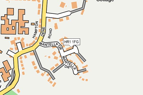
HR1 1FG is located in the Backbury electoral ward, within the unitary authority of Herefordshire, County of and the English Parliamentary constituency of North Herefordshire. The Sub Integrated Care Board (ICB) Location is NHS Herefordshire and Worcestershire ICB - 18C and the police force is West Mercia. This postcode has been in use since April 2017.


GetTheData
Source: OS OpenMap – Local (Ordnance Survey)
Source: OS VectorMap District (Ordnance Survey)
Licence: Open Government Licence (requires attribution)
| Easting | 353497 |
| Northing | 240020 |
| Latitude | 52.056609 |
| Longitude | -2.679641 |
GetTheData
Source: Open Postcode Geo
Licence: Open Government Licence
| Country | England |
| Postcode District | HR1 |
➜ See where HR1 is on a map ➜ Where is Hereford? | |
GetTheData
Source: Land Registry Price Paid Data
Licence: Open Government Licence
| Ward | Backbury |
| Constituency | North Herefordshire |
GetTheData
Source: ONS Postcode Database
Licence: Open Government Licence
2024 21 JUN £425,000 |
2021 6 DEC £330,000 |
2021 30 JUN £360,000 |
2020 26 NOV £380,000 |
2019 13 SEP £275,000 |
16, GREAT CRESTED CRESCENT, HEREFORD, HR1 1FG 2017 15 DEC £293,995 |
2017 26 SEP £327,995 |
14, GREAT CRESTED CRESCENT, HEREFORD, HR1 1FG 2017 29 JUN £389,950 |
15, GREAT CRESTED CRESCENT, HEREFORD, HR1 1FG 2017 29 JUN £341,950 |
2017 29 JUN £379,950 |
GetTheData
Source: HM Land Registry Price Paid Data
Licence: Contains HM Land Registry data © Crown copyright and database right 2025. This data is licensed under the Open Government Licence v3.0.
| Bishops School (Off Hampton Dene Road) | Tupsley | 204m |
| Cock Of Tupsley (A438 Ledbury Road) | Tupsley | 270m |
| Cock Of Tupsley (A438 Ledbury Road) | Tupsley | 277m |
| Deaconsfield (Hampton Dene Road) | Hampton Dene | 377m |
| Biddulph Rise (Whittern Way) | Tupsley | 423m |
| Hereford Station | 2km |
GetTheData
Source: NaPTAN
Licence: Open Government Licence
| Percentage of properties with Next Generation Access | 100.0% |
| Percentage of properties with Superfast Broadband | 100.0% |
| Percentage of properties with Ultrafast Broadband | 100.0% |
| Percentage of properties with Full Fibre Broadband | 100.0% |
Superfast Broadband is between 30Mbps and 300Mbps
Ultrafast Broadband is > 300Mbps
| Percentage of properties unable to receive 2Mbps | 0.0% |
| Percentage of properties unable to receive 5Mbps | 0.0% |
| Percentage of properties unable to receive 10Mbps | 0.0% |
| Percentage of properties unable to receive 30Mbps | 0.0% |
GetTheData
Source: Ofcom
Licence: Ofcom Terms of Use (requires attribution)
GetTheData
Source: ONS Postcode Database
Licence: Open Government Licence


➜ Get more ratings from the Food Standards Agency
GetTheData
Source: Food Standards Agency
Licence: FSA terms & conditions
| Last Collection | |||
|---|---|---|---|
| Location | Mon-Fri | Sat | Distance |
| Upper Ledbury Road | 17:00 | 11:30 | 275m |
| Chilton Square P.o. | 17:15 | 11:30 | 796m |
| Eign Road P.o. | 17:30 | 11:30 | 798m |
GetTheData
Source: Dracos
Licence: Creative Commons Attribution-ShareAlike
The below table lists the International Territorial Level (ITL) codes (formerly Nomenclature of Territorial Units for Statistics (NUTS) codes) and Local Administrative Units (LAU) codes for HR1 1FG:
| ITL 1 Code | Name |
|---|---|
| TLG | West Midlands (England) |
| ITL 2 Code | Name |
| TLG1 | Herefordshire, Worcestershire and Warwickshire |
| ITL 3 Code | Name |
| TLG11 | Herefordshire, County of |
| LAU 1 Code | Name |
| E06000019 | Herefordshire, County of |
GetTheData
Source: ONS Postcode Directory
Licence: Open Government Licence
The below table lists the Census Output Area (OA), Lower Layer Super Output Area (LSOA), and Middle Layer Super Output Area (MSOA) for HR1 1FG:
| Code | Name | |
|---|---|---|
| OA | E00070614 | |
| LSOA | E01013990 | Herefordshire 018A |
| MSOA | E02002922 | Herefordshire 018 |
GetTheData
Source: ONS Postcode Directory
Licence: Open Government Licence
| HR1 1XA | Holywell Gutter Lane | 162m |
| HR1 1UX | Hampton Dene Road | 169m |
| HR1 1UY | Croome Close | 231m |
| HR1 1QW | Ledbury Road | 323m |
| HR1 1XH | Deacons Field | 340m |
| HR1 1AU | Haycroft | 341m |
| HR1 1UR | Rosemary Gardens | 361m |
| HR1 1QZ | Perrystone Lane | 370m |
| HR1 1AT | Queens Wood Drive | 384m |
| HR1 1UW | Rosemary Gardens | 386m |
GetTheData
Source: Open Postcode Geo; Land Registry Price Paid Data
Licence: Open Government Licence