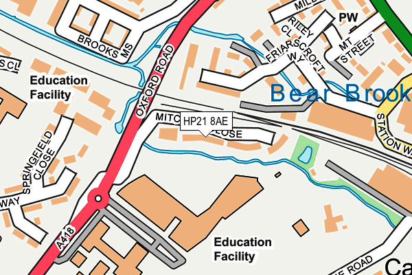
HP21 8AE is located in the Aylesbury South West electoral ward, within the unitary authority of Buckinghamshire and the English Parliamentary constituency of Aylesbury. The Sub Integrated Care Board (ICB) Location is NHS Buckinghamshire, Oxfordshire and Berkshire West ICB - 14Y and the police force is Thames Valley. This postcode has been in use since July 2017.


GetTheData
Source: OS OpenMap – Local (Ordnance Survey)
Source: OS VectorMap District (Ordnance Survey)
Licence: Open Government Licence (requires attribution)
| Easting | 481331 |
| Northing | 213562 |
| Latitude | 51.814788 |
| Longitude | -0.821549 |
GetTheData
Source: Open Postcode Geo
Licence: Open Government Licence
| Country | England |
| Postcode District | HP21 |
➜ See where HP21 is on a map ➜ Where is Aylesbury? | |
GetTheData
Source: Land Registry Price Paid Data
Licence: Open Government Licence
| Ward | Aylesbury South West |
| Constituency | Aylesbury |
GetTheData
Source: ONS Postcode Database
Licence: Open Government Licence
| Aylesbury College (Oxford Road) | Aylesbury | 123m |
| Ta Centre (Oxford Road) | Aylesbury | 176m |
| Aylesbury College (Oxford Road) | Aylesbury | 220m |
| Sir Henry Floyd School (Oxford Road) | Aylesbury | 234m |
| Ta Centre (Oxford Road) | Aylesbury | 270m |
| Aylesbury Station | 0.5km |
| Aylesbury Vale Parkway Station | 3.2km |
| Stoke Mandeville Station | 4km |
GetTheData
Source: NaPTAN
Licence: Open Government Licence
| Percentage of properties with Next Generation Access | 100.0% |
| Percentage of properties with Superfast Broadband | 100.0% |
| Percentage of properties with Ultrafast Broadband | 0.0% |
| Percentage of properties with Full Fibre Broadband | 0.0% |
Superfast Broadband is between 30Mbps and 300Mbps
Ultrafast Broadband is > 300Mbps
| Median download speed | 39.1Mbps |
| Average download speed | 36.5Mbps |
| Maximum download speed | 71.08Mbps |
| Median upload speed | 9.8Mbps |
| Average upload speed | 8.1Mbps |
| Maximum upload speed | 20.00Mbps |
| Percentage of properties unable to receive 2Mbps | 0.0% |
| Percentage of properties unable to receive 5Mbps | 0.0% |
| Percentage of properties unable to receive 10Mbps | 0.0% |
| Percentage of properties unable to receive 30Mbps | 0.0% |
GetTheData
Source: Ofcom
Licence: Ofcom Terms of Use (requires attribution)
GetTheData
Source: ONS Postcode Database
Licence: Open Government Licence


➜ Get more ratings from the Food Standards Agency
GetTheData
Source: Food Standards Agency
Licence: FSA terms & conditions
| Last Collection | |||
|---|---|---|---|
| Location | Mon-Fri | Sat | Distance |
| Friarage Road | 17:30 | 12:00 | 312m |
| Prebendal Ave | 17:00 | 12:00 | 390m |
| Station | 17:30 | 12:00 | 461m |
GetTheData
Source: Dracos
Licence: Creative Commons Attribution-ShareAlike
| Risk of HP21 8AE flooding from rivers and sea | Low |
| ➜ HP21 8AE flood map | |
GetTheData
Source: Open Flood Risk by Postcode
Licence: Open Government Licence
The below table lists the International Territorial Level (ITL) codes (formerly Nomenclature of Territorial Units for Statistics (NUTS) codes) and Local Administrative Units (LAU) codes for HP21 8AE:
| ITL 1 Code | Name |
|---|---|
| TLJ | South East (England) |
| ITL 2 Code | Name |
| TLJ1 | Berkshire, Buckinghamshire and Oxfordshire |
| ITL 3 Code | Name |
| TLJ13 | Buckinghamshire |
| LAU 1 Code | Name |
| E06000060 | Buckinghamshire |
GetTheData
Source: ONS Postcode Directory
Licence: Open Government Licence
The below table lists the Census Output Area (OA), Lower Layer Super Output Area (LSOA), and Middle Layer Super Output Area (MSOA) for HP21 8AE:
| Code | Name | |
|---|---|---|
| OA | E00089364 | |
| LSOA | E01017711 | Aylesbury Vale 018C |
| MSOA | E02003669 | Aylesbury Vale 018 |
GetTheData
Source: ONS Postcode Directory
Licence: Open Government Licence
| HP20 2TE | Friarscroft Way | 79m |
| HP20 2TF | Friarscroft Way | 125m |
| HP19 7XE | Wycliffe End | 158m |
| HP19 7XD | Fowler Road | 177m |
| HP19 7XF | Fowler Road | 203m |
| HP19 7XB | Fowler Road | 212m |
| HP19 7XG | Fowler Road | 229m |
| HP19 8FU | Brooks Mews | 238m |
| HP20 2TH | Riley Close | 248m |
| HP20 2SF | Mill Way | 250m |
GetTheData
Source: Open Postcode Geo; Land Registry Price Paid Data
Licence: Open Government Licence