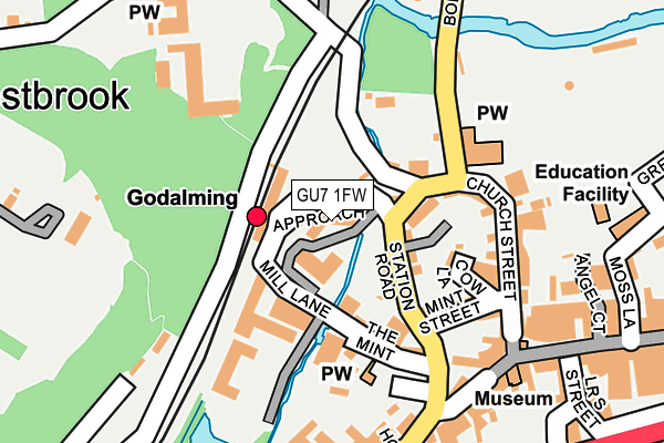
GU7 1FW is located in the Godalming Central & Ockford electoral ward, within the local authority district of Waverley and the English Parliamentary constituency of South West Surrey. The Sub Integrated Care Board (ICB) Location is NHS Surrey Heartlands ICB - 92A and the police force is Surrey. This postcode has been in use since April 2017.


GetTheData
Source: OS OpenMap – Local (Ordnance Survey)
Source: OS VectorMap District (Ordnance Survey)
Licence: Open Government Licence (requires attribution)
| Easting | 496684 |
| Northing | 143937 |
| Latitude | 51.186490 |
| Longitude | -0.617958 |
GetTheData
Source: Open Postcode Geo
Licence: Open Government Licence
| Country | England |
| Postcode District | GU7 |
| ➜ GU7 open data dashboard ➜ See where GU7 is on a map ➜ Where is Godalming? | |
GetTheData
Source: Land Registry Price Paid Data
Licence: Open Government Licence
| Ward | Godalming Central & Ockford |
| Constituency | South West Surrey |
GetTheData
Source: ONS Postcode Database
Licence: Open Government Licence
| January 2024 | Vehicle crime | On or near Parking Area | 144m |
| January 2024 | Criminal damage and arson | On or near Parking Area | 144m |
| April 2023 | Violence and sexual offences | On or near Parking Area | 244m |
| ➜ Get more crime data in our Crime section | |||
GetTheData
Source: data.police.uk
Licence: Open Government Licence
| Godalming Railway Station (Station Approach) | Godalming | 42m |
| Godalming Railway Station (Station Road) | Godalming | 71m |
| Godalming Railway Station (Station Road) | Godalming | 78m |
| Borough Road | Godalming | 154m |
| Borough Road | Godalming | 162m |
| Godalming Station | 0.1km |
| Farncombe Station | 1.5km |
| Milford (Surrey) Station | 2.9km |
GetTheData
Source: NaPTAN
Licence: Open Government Licence
➜ Broadband speed and availability dashboard for GU7 1FW
| Percentage of properties with Next Generation Access | 100.0% |
| Percentage of properties with Superfast Broadband | 100.0% |
| Percentage of properties with Ultrafast Broadband | 0.0% |
| Percentage of properties with Full Fibre Broadband | 0.0% |
Superfast Broadband is between 30Mbps and 300Mbps
Ultrafast Broadband is > 300Mbps
| Median download speed | 43.5Mbps |
| Average download speed | 50.1Mbps |
| Maximum download speed | 80.00Mbps |
| Median upload speed | 10.0Mbps |
| Average upload speed | 10.6Mbps |
| Maximum upload speed | 20.00Mbps |
| Percentage of properties unable to receive 2Mbps | 0.0% |
| Percentage of properties unable to receive 5Mbps | 0.0% |
| Percentage of properties unable to receive 10Mbps | 0.0% |
| Percentage of properties unable to receive 30Mbps | 0.0% |
➜ Broadband speed and availability dashboard for GU7 1FW
GetTheData
Source: Ofcom
Licence: Ofcom Terms of Use (requires attribution)
GetTheData
Source: ONS Postcode Database
Licence: Open Government Licence


➜ Get more ratings from the Food Standards Agency
GetTheData
Source: Food Standards Agency
Licence: FSA terms & conditions
| Last Collection | |||
|---|---|---|---|
| Location | Mon-Fri | Sat | Distance |
| Godalming Station | 17:15 | 12:00 | 62m |
| High Street | 18:45 | 12:00 | 231m |
| Croft Road | 17:15 | 12:00 | 362m |
GetTheData
Source: Dracos
Licence: Creative Commons Attribution-ShareAlike
| Facility | Distance |
|---|---|
| Zest Goldalming Ltd (Closed) Great George Street, Godalming Health and Fitness Gym, Studio | 355m |
| Snap Fitness (Godalming) High Street, Godalming Health and Fitness Gym, Studio | 417m |
| The Burys Field The Burys, Godalming Grass Pitches | 454m |
GetTheData
Source: Active Places
Licence: Open Government Licence
| School | Phase of Education | Distance |
|---|---|---|
| Moss Lane School Moss Lane, Godalming, GU7 1EF | Primary | 262m |
| St Hilary's School Holloway Hill, Godalming, GU7 1RZ | Not applicable | 551m |
| The Wharf Nursery School The Wharf, Woolsack Way, Woolsack Way, Godalming, GU7 1JG | Nursery | 764m |
GetTheData
Source: Edubase
Licence: Open Government Licence
The below table lists the International Territorial Level (ITL) codes (formerly Nomenclature of Territorial Units for Statistics (NUTS) codes) and Local Administrative Units (LAU) codes for GU7 1FW:
| ITL 1 Code | Name |
|---|---|
| TLJ | South East (England) |
| ITL 2 Code | Name |
| TLJ2 | Surrey, East and West Sussex |
| ITL 3 Code | Name |
| TLJ25 | West Surrey |
| LAU 1 Code | Name |
| E07000216 | Waverley |
GetTheData
Source: ONS Postcode Directory
Licence: Open Government Licence
The below table lists the Census Output Area (OA), Lower Layer Super Output Area (LSOA), and Middle Layer Super Output Area (MSOA) for GU7 1FW:
| Code | Name | |
|---|---|---|
| OA | E00157616 | |
| LSOA | E01030914 | Waverley 010A |
| MSOA | E02006448 | Waverley 010 |
GetTheData
Source: ONS Postcode Directory
Licence: Open Government Licence
| GU7 1ET | Westbrook Road | 71m |
| GU7 1TA | Station Road | 72m |
| GU7 1EY | Mill Lane | 94m |
| GU7 1EX | Station Road | 94m |
| GU7 1HD | Mint Street | 123m |
| GU7 1ER | Deanery Place | 128m |
| GU7 1HE | Mint Street | 131m |
| GU7 1HB | The Mint | 132m |
| GU7 1HF | Mill Lane | 146m |
| GU7 1ES | Borough Road | 147m |
GetTheData
Source: Open Postcode Geo; Land Registry Price Paid Data
Licence: Open Government Licence