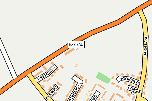
EX9 7AU is located in the Budleigh & Raleigh electoral ward, within the local authority district of East Devon and the English Parliamentary constituency of East Devon. The Sub Integrated Care Board (ICB) Location is NHS Devon ICB - 15N and the police force is Devon & Cornwall. This postcode has been in use since April 2017.


GetTheData
Source: OS OpenMap – Local (Ordnance Survey)
Source: OS VectorMap District (Ordnance Survey)
Licence: Open Government Licence (requires attribution)
| Easting | 305619 |
| Northing | 82981 |
| Latitude | 50.638840 |
| Longitude | -3.336065 |
GetTheData
Source: Open Postcode Geo
Licence: Open Government Licence
| Country | England |
| Postcode District | EX9 |
| ➜ EX9 open data dashboard ➜ See where EX9 is on a map ➜ Where is Budleigh Salterton? | |
GetTheData
Source: Land Registry Price Paid Data
Licence: Open Government Licence
| Ward | Budleigh & Raleigh |
| Constituency | East Devon |
GetTheData
Source: ONS Postcode Database
Licence: Open Government Licence
2, EVANS FIELD, BUDLEIGH SALTERTON, EX9 7AU 2021 26 FEB £350,000 |
18, EVANS FIELD, BUDLEIGH SALTERTON, EX9 7AU 2020 15 OCT £360,000 |
38, EVANS FIELD, BUDLEIGH SALTERTON, EX9 7AU 2020 9 APR £300,000 |
16, EVANS FIELD, BUDLEIGH SALTERTON, EX9 7AU 2019 19 DEC £304,250 |
➜ Budleigh Salterton house prices
GetTheData
Source: HM Land Registry Price Paid Data
Licence: Contains HM Land Registry data © Crown copyright and database right 2024. This data is licensed under the Open Government Licence v3.0.
| October 2022 | Public order | On or near Deepways | 141m |
| June 2022 | Other crime | On or near Queen'S Road | 274m |
| June 2022 | Violence and sexual offences | On or near Sports/Recreation Area | 385m |
| ➜ Get more crime data in our Crime section | |||
GetTheData
Source: data.police.uk
Licence: Open Government Licence
| Higher Bedlands (Bedlands Lane) | Little Knowle | 235m |
| Greenway Lane | Little Knowle | 319m |
| Bedland's Lane (Bedlands Lane) | Budleigh Salterton | 365m |
| Knowle Garage (Knowle Road) | Little Knowle | 597m |
| Tidwell Road (Greenway Lane) | Little Knowle | 602m |
GetTheData
Source: NaPTAN
Licence: Open Government Licence
| Percentage of properties with Next Generation Access | 100.0% |
| Percentage of properties with Superfast Broadband | 100.0% |
| Percentage of properties with Ultrafast Broadband | 0.0% |
| Percentage of properties with Full Fibre Broadband | 0.0% |
Superfast Broadband is between 30Mbps and 300Mbps
Ultrafast Broadband is > 300Mbps
| Percentage of properties unable to receive 2Mbps | 0.0% |
| Percentage of properties unable to receive 5Mbps | 0.0% |
| Percentage of properties unable to receive 10Mbps | 0.0% |
| Percentage of properties unable to receive 30Mbps | 0.0% |
GetTheData
Source: Ofcom
Licence: Ofcom Terms of Use (requires attribution)
GetTheData
Source: ONS Postcode Database
Licence: Open Government Licence


➜ Get more ratings from the Food Standards Agency
GetTheData
Source: Food Standards Agency
Licence: FSA terms & conditions
| Last Collection | |||
|---|---|---|---|
| Location | Mon-Fri | Sat | Distance |
| Bedlands Lane | 17:45 | 11:45 | 249m |
| Station Road | 18:15 | 12:00 | 828m |
| Fore Street | 17:45 | 11:45 | 1,471m |
GetTheData
Source: Dracos
Licence: Creative Commons Attribution-ShareAlike
| Facility | Distance |
|---|---|
| Budleigh Salterton Football Club Greenway Lane, Budleigh Salterton Grass Pitches | 390m |
| Budleigh Salterton Games Club Cricket Field Lane, Budleigh Salterton Indoor Bowls, Outdoor Tennis Courts | 1.2km |
| East Devon Golf Club Links Road, Budleigh Salterton Golf | 1.3km |
GetTheData
Source: Active Places
Licence: Open Government Licence
| School | Phase of Education | Distance |
|---|---|---|
| St Peter's Church of England Primary School Moor Lane, St. Peters C of E Primary School, Budleigh Salterton, EX9 6QF | Primary | 406m |
| Drake's Church of England Primary School Middle Street, East Budleigh, Budleigh Salterton, EX9 7DQ | Primary | 1.9km |
| Otterton Church of England Primary School Church Hill, Otterton, Budleigh Salterton, EX9 7HU | Primary | 3.3km |
GetTheData
Source: Edubase
Licence: Open Government Licence
The below table lists the International Territorial Level (ITL) codes (formerly Nomenclature of Territorial Units for Statistics (NUTS) codes) and Local Administrative Units (LAU) codes for EX9 7AU:
| ITL 1 Code | Name |
|---|---|
| TLK | South West (England) |
| ITL 2 Code | Name |
| TLK4 | Devon |
| ITL 3 Code | Name |
| TLK43 | Devon CC |
| LAU 1 Code | Name |
| E07000040 | East Devon |
GetTheData
Source: ONS Postcode Directory
Licence: Open Government Licence
The below table lists the Census Output Area (OA), Lower Layer Super Output Area (LSOA), and Middle Layer Super Output Area (MSOA) for EX9 7AU:
| Code | Name | |
|---|---|---|
| OA | E00100688 | |
| LSOA | E01019897 | East Devon 017D |
| MSOA | E02004145 | East Devon 017 |
GetTheData
Source: ONS Postcode Directory
Licence: Open Government Licence
| EX9 6RA | Deepways | 131m |
| EX9 6QW | Shortwood Close | 147m |
| EX9 6QP | Frewins | 151m |
| EX9 6QL | Dukes Road | 181m |
| EX9 6QN | Bedlands Lane | 205m |
| EX9 6QX | Hooker Close | 221m |
| EX9 6QY | Forge Close | 261m |
| EX9 6QU | Higher Bedlands | 268m |
| EX9 6QJ | Queens Road | 276m |
| EX9 6QG | Barn Lane | 298m |
GetTheData
Source: Open Postcode Geo; Land Registry Price Paid Data
Licence: Open Government Licence