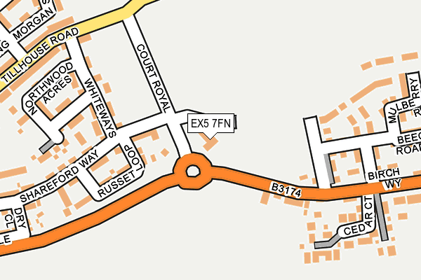
EX5 7FN is located in the Cranbrook electoral ward, within the local authority district of East Devon and the English Parliamentary constituency of East Devon. The Sub Integrated Care Board (ICB) Location is NHS Devon ICB - 15N and the police force is Devon & Cornwall. This postcode has been in use since April 2017.


GetTheData
Source: OS OpenMap – Local (Ordnance Survey)
Source: OS VectorMap District (Ordnance Survey)
Licence: Open Government Licence (requires attribution)
| Easting | 301356 |
| Northing | 95476 |
| Latitude | 50.750465 |
| Longitude | -3.399673 |
GetTheData
Source: Open Postcode Geo
Licence: Open Government Licence
| Country | England |
| Postcode District | EX5 |
| ➜ EX5 open data dashboard ➜ See where EX5 is on a map ➜ Where is Cranbrook? | |
GetTheData
Source: Land Registry Price Paid Data
Licence: Open Government Licence
| Ward | Cranbrook |
| Constituency | East Devon |
GetTheData
Source: ONS Postcode Database
Licence: Open Government Licence
| June 2022 | Violence and sexual offences | On or near Petrol Station | 108m |
| June 2022 | Violence and sexual offences | On or near Petrol Station | 108m |
| June 2022 | Criminal damage and arson | On or near Petrol Station | 108m |
| ➜ Get more crime data in our Crime section | |||
GetTheData
Source: data.police.uk
Licence: Open Government Licence
| Shareford Way | Cranbrook | 170m |
| Shareford Way | Cranbrook | 175m |
| Garage (B3174) | Rockbeare | 206m |
| Garage (B3174) | Rockbeare | 215m |
| Sweet Coppin (Tillhouse Road) | Cranbrook | 319m |
| Cranbrook Station | 1.5km |
| Whimple Station | 3.7km |
| Pinhoe Station | 5.1km |
GetTheData
Source: NaPTAN
Licence: Open Government Licence
GetTheData
Source: ONS Postcode Database
Licence: Open Government Licence


➜ Get more ratings from the Food Standards Agency
GetTheData
Source: Food Standards Agency
Licence: FSA terms & conditions
| Last Collection | |||
|---|---|---|---|
| Location | Mon-Fri | Sat | Distance |
| Hand & Pen | 16:30 | 09:00 | 3,522m |
| Broadclyst Post Office | 17:25 | 11:45 | 3,579m |
| Stonefield | 16:10 | 09:00 | 3,968m |
GetTheData
Source: Dracos
Licence: Creative Commons Attribution-ShareAlike
| Facility | Distance |
|---|---|
| Cranbrook Education Campus Tillhouse Road, Cranbrook, Exeter Artificial Grass Pitch, Studio, Sports Hall | 545m |
| Rockbeare C Of E Primary School & Preschool Rockbeare, Exeter Grass Pitches | 786m |
| Rockbeare Playing Fields Lowbrook, Rockbeare Grass Pitches | 982m |
GetTheData
Source: Active Places
Licence: Open Government Licence
| School | Phase of Education | Distance |
|---|---|---|
| Cranbrook Education Campus Tillhouse Road, Cranbrook, Cranbrook Education Campus, Exeter, EX5 7EE | All-through | 460m |
| Rockbeare Church of England Primary School and Pre-School Rockbeare, Exeter, EX5 2EQ | Primary | 785m |
| St Martin's CofE Primary & Nursery School Younghayes Road, Cranbrook, Exeter, EX5 7DT | Primary | 1.1km |
GetTheData
Source: Edubase
Licence: Open Government Licence
The below table lists the International Territorial Level (ITL) codes (formerly Nomenclature of Territorial Units for Statistics (NUTS) codes) and Local Administrative Units (LAU) codes for EX5 7FN:
| ITL 1 Code | Name |
|---|---|
| TLK | South West (England) |
| ITL 2 Code | Name |
| TLK4 | Devon |
| ITL 3 Code | Name |
| TLK43 | Devon CC |
| LAU 1 Code | Name |
| E07000040 | East Devon |
GetTheData
Source: ONS Postcode Directory
Licence: Open Government Licence
The below table lists the Census Output Area (OA), Lower Layer Super Output Area (LSOA), and Middle Layer Super Output Area (MSOA) for EX5 7FN:
| Code | Name | |
|---|---|---|
| OA | E00100663 | |
| LSOA | E01019892 | East Devon 006B |
| MSOA | E02004134 | East Devon 006 |
GetTheData
Source: ONS Postcode Directory
Licence: Open Government Licence
| EX5 2DZ | New Cottages | 140m |
| EX5 7EY | Russet Loop | 155m |
| EX5 2EA | London Road | 219m |
| EX5 7EZ | Shareford Way | 237m |
| EX5 2EB | London Road | 300m |
| EX5 7ET | Morgan Sweet | 317m |
| EX5 7FE | Tillhouse Road | 321m |
| EX5 2ED | London Road | 357m |
| EX5 7FD | Tillhouse Road | 358m |
| EX5 7ES | Long Culvering | 381m |
GetTheData
Source: Open Postcode Geo; Land Registry Price Paid Data
Licence: Open Government Licence