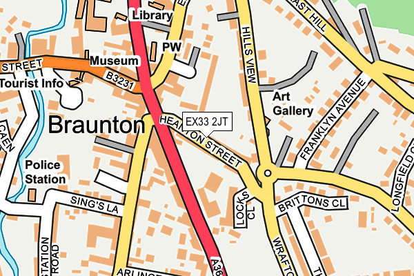
EX33 2JT is located in the Braunton East electoral ward, within the local authority district of North Devon and the English Parliamentary constituency of North Devon. The Sub Integrated Care Board (ICB) Location is NHS Devon ICB - 15N and the police force is Devon & Cornwall. This postcode has been in use since June 2017.


GetTheData
Source: OS OpenMap – Local (Ordnance Survey)
Source: OS VectorMap District (Ordnance Survey)
Licence: Open Government Licence (requires attribution)
| Easting | 248832 |
| Northing | 136515 |
| Latitude | 51.107940 |
| Longitude | -4.160785 |
GetTheData
Source: Open Postcode Geo
Licence: Open Government Licence
| Country | England |
| Postcode District | EX33 |
| ➜ EX33 open data dashboard ➜ See where EX33 is on a map ➜ Where is Braunton? | |
GetTheData
Source: Land Registry Price Paid Data
Licence: Open Government Licence
| Ward | Braunton East |
| Constituency | North Devon |
GetTheData
Source: ONS Postcode Database
Licence: Open Government Licence
| June 2022 | Violence and sexual offences | On or near Supermarket | 38m |
| June 2022 | Violence and sexual offences | On or near Philips Lane | 185m |
| June 2022 | Violence and sexual offences | On or near Caen Street | 187m |
| ➜ Get more crime data in our Crime section | |||
GetTheData
Source: data.police.uk
Licence: Open Government Licence
| Sq Resturant (Exeter Road) | Braunton | 40m |
| George Hotel (Exeter Road) | Braunton | 45m |
| The Bridge (Caen Street) | Braunton | 212m |
| The Bridge (Caen Street) | Braunton | 216m |
| Field Lane (B3231) | Braunton | 441m |
GetTheData
Source: NaPTAN
Licence: Open Government Licence
GetTheData
Source: ONS Postcode Database
Licence: Open Government Licence


➜ Get more ratings from the Food Standards Agency
GetTheData
Source: Food Standards Agency
Licence: FSA terms & conditions
| Last Collection | |||
|---|---|---|---|
| Location | Mon-Fri | Sat | Distance |
| Caen Street | 17:30 | 12:15 | 166m |
| Caen Street | 17:30 | 12:00 | 166m |
| South Street | 17:15 | 10:00 | 823m |
GetTheData
Source: Dracos
Licence: Creative Commons Attribution-ShareAlike
| Facility | Distance |
|---|---|
| Caen Community Primary School Caen Street, Braunton Swimming Pool, Grass Pitches | 186m |
| Braunton Recreation Ground Wrafton Road, Braunton Grass Pitches | 263m |
| Braunton Cricket Club First Field Lane, Braunton Grass Pitches | 535m |
GetTheData
Source: Active Places
Licence: Open Government Licence
| School | Phase of Education | Distance |
|---|---|---|
| Caen Community Primary School Caen Street, Braunton, EX33 1AD | Primary | 214m |
| Southmead School Wrafton Road, Braunton, EX33 2BU | Primary | 640m |
| Braunton Academy Barton Lane, Braunton, EX33 2BP | Secondary | 660m |
GetTheData
Source: Edubase
Licence: Open Government Licence
The below table lists the International Territorial Level (ITL) codes (formerly Nomenclature of Territorial Units for Statistics (NUTS) codes) and Local Administrative Units (LAU) codes for EX33 2JT:
| ITL 1 Code | Name |
|---|---|
| TLK | South West (England) |
| ITL 2 Code | Name |
| TLK4 | Devon |
| ITL 3 Code | Name |
| TLK43 | Devon CC |
| LAU 1 Code | Name |
| E07000043 | North Devon |
GetTheData
Source: ONS Postcode Directory
Licence: Open Government Licence
The below table lists the Census Output Area (OA), Lower Layer Super Output Area (LSOA), and Middle Layer Super Output Area (MSOA) for EX33 2JT:
| Code | Name | |
|---|---|---|
| OA | E00101731 | |
| LSOA | E01020089 | North Devon 005A |
| MSOA | E02004179 | North Devon 005 |
GetTheData
Source: ONS Postcode Directory
Licence: Open Government Licence
| EX33 2JS | Heanton Street | 54m |
| EX33 2JD | The Square | 62m |
| EX33 2PB | Dyers Close | 90m |
| EX33 2JB | The Square | 101m |
| EX33 2ET | South Street | 102m |
| EX33 2JA | Chaloners Road | 105m |
| EX33 2JL | Exeter Road | 112m |
| EX33 2AA | South Street | 123m |
| EX33 2JR | Exeter Road | 135m |
| EX33 2EB | Bias Lane | 142m |
GetTheData
Source: Open Postcode Geo; Land Registry Price Paid Data
Licence: Open Government Licence