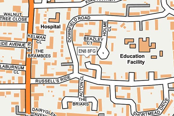
EN8 8FG is located in the Cheshunt South and Theobalds electoral ward, within the local authority district of Broxbourne and the English Parliamentary constituency of Broxbourne. The Sub Integrated Care Board (ICB) Location is NHS Hertfordshire and West Essex ICB - 06K and the police force is Hertfordshire. This postcode has been in use since April 2017.


GetTheData
Source: OS OpenMap – Local (Ordnance Survey)
Source: OS VectorMap District (Ordnance Survey)
Licence: Open Government Licence (requires attribution)
| Easting | 536138 |
| Northing | 201758 |
| Latitude | 51.698068 |
| Longitude | -0.031509 |
GetTheData
Source: Open Postcode Geo
Licence: Open Government Licence
| Country | England |
| Postcode District | EN8 |
| ➜ EN8 open data dashboard ➜ See where EN8 is on a map ➜ Where is Cheshunt? | |
GetTheData
Source: Land Registry Price Paid Data
Licence: Open Government Licence
| Ward | Cheshunt South And Theobalds |
| Constituency | Broxbourne |
GetTheData
Source: ONS Postcode Database
Licence: Open Government Licence
| January 2024 | Violence and sexual offences | On or near Downfield Road | 174m |
| December 2023 | Violence and sexual offences | On or near Downfield Road | 174m |
| October 2023 | Violence and sexual offences | On or near Friends Avenue | 424m |
| ➜ Get more crime data in our Crime section | |||
GetTheData
Source: data.police.uk
Licence: Open Government Licence
| The Roman Urn Ph (Crossbrook Street) | Theobalds Grove | 237m |
| King Arthur Court (Turners Hill) | Cheshunt | 295m |
| The Roman Urn Ph (Crossbrook Street) | Theobalds Grove | 301m |
| Old Pond (Crossbrook Street) | Cheshunt | 406m |
| Old Pond (Turners Hill) | Cheshunt | 471m |
| Theobalds Grove Station | 0.7km |
| Cheshunt Station | 0.7km |
| Waltham Cross Station | 1.5km |
GetTheData
Source: NaPTAN
Licence: Open Government Licence
| Percentage of properties with Next Generation Access | 100.0% |
| Percentage of properties with Superfast Broadband | 100.0% |
| Percentage of properties with Ultrafast Broadband | 0.0% |
| Percentage of properties with Full Fibre Broadband | 0.0% |
Superfast Broadband is between 30Mbps and 300Mbps
Ultrafast Broadband is > 300Mbps
| Percentage of properties unable to receive 2Mbps | 0.0% |
| Percentage of properties unable to receive 5Mbps | 0.0% |
| Percentage of properties unable to receive 10Mbps | 0.0% |
| Percentage of properties unable to receive 30Mbps | 0.0% |
GetTheData
Source: Ofcom
Licence: Ofcom Terms of Use (requires attribution)
GetTheData
Source: ONS Postcode Database
Licence: Open Government Licence


➜ Get more ratings from the Food Standards Agency
GetTheData
Source: Food Standards Agency
Licence: FSA terms & conditions
| Last Collection | |||
|---|---|---|---|
| Location | Mon-Fri | Sat | Distance |
| Chesthunt P.o | 18:15 | 12:00 | 80m |
| Cheshunt Library | 17:30 | 11:30 | 231m |
| Crossbrook Street | 18:30 | 11:30 | 315m |
GetTheData
Source: Dracos
Licence: Creative Commons Attribution-ShareAlike
| Facility | Distance |
|---|---|
| Laura Trott Leisure Centre Windmill Lane, Cheshunt, Waltham Cross Sports Hall, Swimming Pool, Health and Fitness Gym, Studio, Squash Courts, Artificial Grass Pitch | 399m |
| Holy Trinity Primary School Crossbrook Street, Cheshunt, Waltham Cross Grass Pitches | 494m |
| Cheshunt Community Sports Park Albury Ride, Cheshunt Indoor Bowls, Grass Pitches, Squash Courts, Studio | 585m |
GetTheData
Source: Active Places
Licence: Open Government Licence
| School | Phase of Education | Distance |
|---|---|---|
| Downfield Primary School Downfield Road, Cheshunt, Waltham Cross, EN8 8SS | Primary | 193m |
| Holy Trinity Church of England Primary School Longlands Close, Crossbrook Street, Holy Trinity School, Waltham Cross, EN8 8LU | Primary | 489m |
| St Joseph's Catholic Primary School (Wx) Royal Avenue, Waltham Cross, EN8 7EN | Primary | 771m |
GetTheData
Source: Edubase
Licence: Open Government Licence
The below table lists the International Territorial Level (ITL) codes (formerly Nomenclature of Territorial Units for Statistics (NUTS) codes) and Local Administrative Units (LAU) codes for EN8 8FG:
| ITL 1 Code | Name |
|---|---|
| TLH | East |
| ITL 2 Code | Name |
| TLH2 | Bedfordshire and Hertfordshire |
| ITL 3 Code | Name |
| TLH23 | Hertfordshire CC |
| LAU 1 Code | Name |
| E07000095 | Broxbourne |
GetTheData
Source: ONS Postcode Directory
Licence: Open Government Licence
The below table lists the Census Output Area (OA), Lower Layer Super Output Area (LSOA), and Middle Layer Super Output Area (MSOA) for EN8 8FG:
| Code | Name | |
|---|---|---|
| OA | E00118378 | |
| LSOA | E01023300 | Broxbourne 010D |
| MSOA | E02004852 | Broxbourne 010 |
GetTheData
Source: ONS Postcode Directory
Licence: Open Government Licence
| EN8 8TA | Downfield Road | 26m |
| EN8 8SU | Holme Close | 48m |
| EN8 8SY | Wood Green Way | 50m |
| EN8 8TT | Russells Ride | 67m |
| EN8 8SP | Downfield Road | 91m |
| EN8 8ST | Holme Close | 97m |
| EN8 8SZ | Downfield Road | 112m |
| EN8 8TS | Russells Ride | 116m |
| EN8 8SN | Acton Close | 127m |
| EN8 8JD | The Brambles | 130m |
GetTheData
Source: Open Postcode Geo; Land Registry Price Paid Data
Licence: Open Government Licence