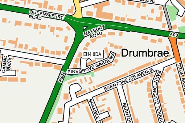
EH4 8DA is located in the Almond electoral ward, within the council area of City of Edinburgh and the Scottish Parliamentary constituency of Edinburgh West. The Community Health Partnership is Edinburgh Community Health Partnership and the police force is Scotland. This postcode has been in use since July 2003.


GetTheData
Source: OS OpenMap – Local (Ordnance Survey)
Source: OS VectorMap District (Ordnance Survey)
Licence: Open Government Licence (requires attribution)
| Easting | 318613 |
| Northing | 674831 |
| Latitude | 55.959574 |
| Longitude | -3.305172 |
GetTheData
Source: Open Postcode Geo
Licence: Open Government Licence
| Country | Scotland |
| Postcode District | EH4 |
| ➜ EH4 open data dashboard ➜ See where EH4 is on a map ➜ Where is Edinburgh? | |
GetTheData
Source: Land Registry Price Paid Data
Licence: Open Government Licence
| Ward | Almond |
| Constituency | Edinburgh West |
GetTheData
Source: ONS Postcode Database
Licence: Open Government Licence
| Barnton Junction (Queensferry Road) | Barnton | 138m |
| Barnton Junction (Queensferry Road) | Barnton | 155m |
| Barnton Junction (Maybury Road) | Drumbrae | 195m |
| Barnton Grove (Whitehouse Road) | Braepark | 219m |
| Barnton Grove (Whitehouse Road) | Braepark | 240m |
| South Gyle Station | 2.6km |
| Edinburgh Park Station | 3.6km |
| Kingsknowe Station | 5.2km |
GetTheData
Source: NaPTAN
Licence: Open Government Licence
➜ Broadband speed and availability dashboard for EH4 8DA
| Percentage of properties with Next Generation Access | 100.0% |
| Percentage of properties with Superfast Broadband | 100.0% |
| Percentage of properties with Ultrafast Broadband | 53.8% |
| Percentage of properties with Full Fibre Broadband | 0.0% |
Superfast Broadband is between 30Mbps and 300Mbps
Ultrafast Broadband is > 300Mbps
| Median download speed | 8.9Mbps |
| Average download speed | 66.3Mbps |
| Maximum download speed | 350.00Mbps |
| Median upload speed | 1.1Mbps |
| Average upload speed | 1.0Mbps |
| Maximum upload speed | 1.23Mbps |
| Percentage of properties unable to receive 2Mbps | 0.0% |
| Percentage of properties unable to receive 5Mbps | 0.0% |
| Percentage of properties unable to receive 10Mbps | 0.0% |
| Percentage of properties unable to receive 30Mbps | 0.0% |
➜ Broadband speed and availability dashboard for EH4 8DA
GetTheData
Source: Ofcom
Licence: Ofcom Terms of Use (requires attribution)
Estimated total energy consumption in EH4 8DA by fuel type, 2015.
| Consumption (kWh) | 279,407 |
|---|---|
| Meter count | 22 |
| Mean (kWh/meter) | 12,700 |
| Median (kWh/meter) | 11,740 |
| Consumption (kWh) | 142,653 |
|---|---|
| Meter count | 33 |
| Mean (kWh/meter) | 4,323 |
| Median (kWh/meter) | 3,914 |
GetTheData
Source: Postcode level gas estimates: 2015 (experimental)
Source: Postcode level electricity estimates: 2015 (experimental)
Licence: Open Government Licence
GetTheData
Source: ONS Postcode Database
Licence: Open Government Licence


➜ Get more ratings from the Food Standards Agency
GetTheData
Source: Food Standards Agency
Licence: FSA terms & conditions
| Last Collection | |||
|---|---|---|---|
| Location | Mon-Fri | Sat | Distance |
| Barnton Post Office | 18:30 | 12:15 | 207m |
| 3 Drumbrae North | 17:45 | 12:30 | 284m |
| 75 Barnton Park View | 17:30 | 12:15 | 368m |
GetTheData
Source: Dracos
Licence: Creative Commons Attribution-ShareAlike
The below table lists the International Territorial Level (ITL) codes (formerly Nomenclature of Territorial Units for Statistics (NUTS) codes) and Local Administrative Units (LAU) codes for EH4 8DA:
| ITL 1 Code | Name |
|---|---|
| TLM | Scotland |
| ITL 2 Code | Name |
| TLM7 | Eastern Scotland |
| ITL 3 Code | Name |
| TLM75 | City of Edinburgh |
| LAU 1 Code | Name |
| S30000008 | City of Edinburgh |
GetTheData
Source: ONS Postcode Directory
Licence: Open Government Licence
The below table lists the Census Output Area (OA), Lower Layer Super Output Area (LSOA), and Middle Layer Super Output Area (MSOA) for EH4 8DA:
| Code | Name | |
|---|---|---|
| OA | S00103908 | |
| LSOA | S01008946 | Barnton, Cammo and Cramond South - 03 |
| MSOA | S02001674 | Barnton, Cammo and Cramond South |
GetTheData
Source: ONS Postcode Directory
Licence: Open Government Licence