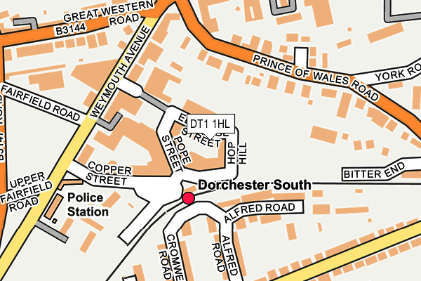
DT1 1HL is located in the Dorchester East electoral ward, within the unitary authority of Dorset and the English Parliamentary constituency of West Dorset. The Sub Integrated Care Board (ICB) Location is NHS Dorset ICB - 11J and the police force is Dorset. This postcode has been in use since February 2017.


GetTheData
Source: OS OpenMap – Local (Ordnance Survey)
Source: OS VectorMap District (Ordnance Survey)
Licence: Open Government Licence (requires attribution)
| Easting | 369268 |
| Northing | 90123 |
| Latitude | 50.709913 |
| Longitude | -2.436609 |
GetTheData
Source: Open Postcode Geo
Licence: Open Government Licence
| Country | England |
| Postcode District | DT1 |
| ➜ DT1 open data dashboard ➜ See where DT1 is on a map ➜ Where is Dorchester? | |
GetTheData
Source: Land Registry Price Paid Data
Licence: Open Government Licence
| Ward | Dorchester East |
| Constituency | West Dorset |
GetTheData
Source: ONS Postcode Database
Licence: Open Government Licence
| October 2023 | Other theft | On or near Parking Area | 221m |
| August 2023 | Violence and sexual offences | On or near Barnes Way | 451m |
| July 2023 | Violence and sexual offences | On or near Parking Area | 221m |
| ➜ Get more crime data in our Crime section | |||
GetTheData
Source: data.police.uk
Licence: Open Government Licence
| South Station (Station Approach) | Dorchester | 115m |
| Brewery Square (Weymouth Avenue) | Dorchester | 179m |
| Brewery Square (Weymouth Avenue) | Dorchester | 185m |
| Monmouth Road (Rothesay Road) | Dorchester | 242m |
| Prince Of Wales Road | Dorchester | 296m |
| Dorchester South Station | 0.1km |
| Dorchester West Station | 0.4km |
GetTheData
Source: NaPTAN
Licence: Open Government Licence
➜ Broadband speed and availability dashboard for DT1 1HL
| Percentage of properties with Next Generation Access | 100.0% |
| Percentage of properties with Superfast Broadband | 100.0% |
| Percentage of properties with Ultrafast Broadband | 100.0% |
| Percentage of properties with Full Fibre Broadband | 100.0% |
Superfast Broadband is between 30Mbps and 300Mbps
Ultrafast Broadband is > 300Mbps
| Median download speed | 19.6Mbps |
| Average download speed | 18.4Mbps |
| Maximum download speed | 22.94Mbps |
| Median upload speed | 1.2Mbps |
| Average upload speed | 1.1Mbps |
| Maximum upload speed | 1.26Mbps |
| Percentage of properties unable to receive 2Mbps | 0.0% |
| Percentage of properties unable to receive 5Mbps | 0.0% |
| Percentage of properties unable to receive 10Mbps | 0.0% |
| Percentage of properties unable to receive 30Mbps | 0.0% |
➜ Broadband speed and availability dashboard for DT1 1HL
GetTheData
Source: Ofcom
Licence: Ofcom Terms of Use (requires attribution)
GetTheData
Source: ONS Postcode Database
Licence: Open Government Licence


➜ Get more ratings from the Food Standards Agency
GetTheData
Source: Food Standards Agency
Licence: FSA terms & conditions
| Last Collection | |||
|---|---|---|---|
| Location | Mon-Fri | Sat | Distance |
| South Station | 17:30 | 11:30 | 213m |
| South Walks | 17:30 | 11:30 | 234m |
| Trinity Street | 17:30 | 13:00 | 376m |
GetTheData
Source: Dracos
Licence: Creative Commons Attribution-ShareAlike
| Facility | Distance |
|---|---|
| Anytime Fitness (Dorchester) Eldridge Street, Eldridge Street, Dorchester Health and Fitness Gym | 156m |
| Sunninghill Preparatory School South Walks Road, Dorchester Grass Pitches, Swimming Pool, Outdoor Tennis Courts | 375m |
| Borough Gardens Cornwall Road, Dorchester Outdoor Tennis Courts | 398m |
GetTheData
Source: Active Places
Licence: Open Government Licence
| School | Phase of Education | Distance |
|---|---|---|
| Sunninghill Preparatory School South Court, South Walks, Dorchester, DT1 1EB | Not applicable | 380m |
| St Mary's Catholic First School, Dorchester Lucetta Lane, Dorchester, DT1 2DD | Primary | 537m |
| St Osmund's Church of England Middle School Barnes Way, Dorchester, DT1 2DZ | Middle deemed secondary | 641m |
GetTheData
Source: Edubase
Licence: Open Government Licence
The below table lists the International Territorial Level (ITL) codes (formerly Nomenclature of Territorial Units for Statistics (NUTS) codes) and Local Administrative Units (LAU) codes for DT1 1HL:
| ITL 1 Code | Name |
|---|---|
| TLK | South West (England) |
| ITL 2 Code | Name |
| TLK2 | Dorset and Somerset |
| ITL 3 Code | Name |
| TLK25 | Dorset |
| LAU 1 Code | Name |
| E06000059 | Dorset |
GetTheData
Source: ONS Postcode Directory
Licence: Open Government Licence
The below table lists the Census Output Area (OA), Lower Layer Super Output Area (LSOA), and Middle Layer Super Output Area (MSOA) for DT1 1HL:
| Code | Name | |
|---|---|---|
| OA | E00104066 | |
| LSOA | E01032645 | West Dorset 009I |
| MSOA | E02004277 | West Dorset 009 |
GetTheData
Source: ONS Postcode Directory
Licence: Open Government Licence
| DT1 1GJ | Copper Street | 99m |
| DT1 1PW | Prince Of Wales Road | 114m |
| DT1 1GR | Maumbury Gardens | 116m |
| DT1 2DW | Alfred Road | 125m |
| DT1 1WF | Maumbury Gardens | 135m |
| DT1 1GY | Eldridge Street | 145m |
| DT1 1GT | Dray Horse Yard | 156m |
| DT1 1QX | Station Approach | 156m |
| DT1 1QR | Weymouth Avenue | 158m |
| DT1 2DN | Cromwell Road | 163m |
GetTheData
Source: Open Postcode Geo; Land Registry Price Paid Data
Licence: Open Government Licence