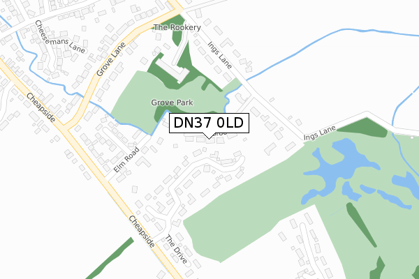
DN37 0LD maps, stats, and open data
DN37 0LD is located in the Waltham electoral ward, within the unitary authority of North East Lincolnshire and the English Parliamentary constituency of Cleethorpes. The Sub Integrated Care Board (ICB) Location is NHS Humber and North Yorkshire ICB - 03H and the police force is Humberside. This postcode has been in use since December 2017.
DN37 0LD maps


Licence: Open Government Licence (requires attribution)
Attribution: Contains OS data © Crown copyright and database right 2025
Source: Open Postcode Geo
Licence: Open Government Licence (requires attribution)
Attribution: Contains OS data © Crown copyright and database right 2025; Contains Royal Mail data © Royal Mail copyright and database right 2025; Source: Office for National Statistics licensed under the Open Government Licence v.3.0
DN37 0LD geodata
| Easting | 526639 |
| Northing | 403413 |
| Latitude | 53.512178 |
| Longitude | -0.091727 |
Where is DN37 0LD?
| Country | England |
| Postcode District | DN37 |
Politics
| Ward | Waltham |
|---|---|
| Constituency | Cleethorpes |
House Prices
Sales of detached houses in DN37 0LD
2022 29 JUL £545,000 |
7, BROOK LANE, WALTHAM, GRIMSBY, DN37 0LD 2022 25 MAY £200,000 |
2020 18 DEC £465,000 |
9, BROOK LANE, WALTHAM, GRIMSBY, DN37 0LD 2020 19 JUN £615,000 |
2018 9 MAY £160,000 |
3, BROOK LANE, WALTHAM, GRIMSBY, DN37 0LD 2017 24 APR £200,000 |
10, BROOK LANE, WALTHAM, GRIMSBY, DN37 0LD 2017 13 MAR £200,000 |
Licence: Contains HM Land Registry data © Crown copyright and database right 2025. This data is licensed under the Open Government Licence v3.0.
Transport
Nearest bus stops to DN37 0LD
| Ings Lane (High Street) | Waltham | 653m |
| Church Lane (High Street) | Waltham | 669m |
| Ings Lane (High Street) | Waltham | 669m |
| Church Lane (High Street) | Waltham | 689m |
| Fire Station (Station Road) | Waltham | 710m |
Broadband
Broadband access in DN37 0LD (2020 data)
| Percentage of properties with Next Generation Access | 100.0% |
| Percentage of properties with Superfast Broadband | 100.0% |
| Percentage of properties with Ultrafast Broadband | 83.3% |
| Percentage of properties with Full Fibre Broadband | 0.0% |
Superfast Broadband is between 30Mbps and 300Mbps
Ultrafast Broadband is > 300Mbps
Broadband limitations in DN37 0LD (2020 data)
| Percentage of properties unable to receive 2Mbps | 0.0% |
| Percentage of properties unable to receive 5Mbps | 0.0% |
| Percentage of properties unable to receive 10Mbps | 0.0% |
| Percentage of properties unable to receive 30Mbps | 0.0% |
Deprivation
4.6% of English postcodes are less deprived than DN37 0LD:Food Standards Agency
Three nearest food hygiene ratings to DN37 0LD (metres)


➜ Get more ratings from the Food Standards Agency
Nearest post box to DN37 0LD
| Last Collection | |||
|---|---|---|---|
| Location | Mon-Fri | Sat | Distance |
| Cheapside | 16:00 | 10:45 | 305m |
| Fairway | 16:00 | 11:30 | 1,103m |
| Archer Road | 16:00 | 10:45 | 1,273m |
DN37 0LD ITL and DN37 0LD LAU
The below table lists the International Territorial Level (ITL) codes (formerly Nomenclature of Territorial Units for Statistics (NUTS) codes) and Local Administrative Units (LAU) codes for DN37 0LD:
| ITL 1 Code | Name |
|---|---|
| TLE | Yorkshire and The Humber |
| ITL 2 Code | Name |
| TLE1 | East Yorkshire and Northern Lincolnshire |
| ITL 3 Code | Name |
| TLE13 | North and North East Lincolnshire |
| LAU 1 Code | Name |
| E06000012 | North East Lincolnshire |
DN37 0LD census areas
The below table lists the Census Output Area (OA), Lower Layer Super Output Area (LSOA), and Middle Layer Super Output Area (MSOA) for DN37 0LD:
| Code | Name | |
|---|---|---|
| OA | E00173598 | |
| LSOA | E01013215 | North East Lincolnshire 023C |
| MSOA | E02002748 | North East Lincolnshire 023 |
Nearest postcodes to DN37 0LD
| DN37 0HB | Ings Lane | 120m |
| DN37 0FB | The Drive | 151m |
| DN37 0HR | Elm Road | 187m |
| DN37 0EY | Ings Lane | 215m |
| DN37 0HP | Cheapside | 216m |
| DN37 0HS | Greenway | 229m |
| DN37 0HD | Grove Lane | 322m |
| DN37 0HW | Cheapside | 394m |
| DN37 0EU | Skinners Lane | 425m |
| DN37 0EP | Cheesemans Lane | 437m |