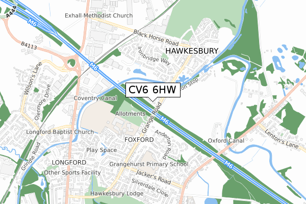
CV6 6HW is located in the Longford electoral ward, within the metropolitan district of Coventry and the English Parliamentary constituency of Coventry North East. The Sub Integrated Care Board (ICB) Location is NHS Coventry and Warwickshire ICB - B2M3M and the police force is West Midlands. This postcode has been in use since January 2019.


GetTheData
Source: OS Open Zoomstack (Ordnance Survey)
Licence: Open Government Licence (requires attribution)
Attribution: Contains OS data © Crown copyright and database right 2024
Source: Open Postcode Geo
Licence: Open Government Licence (requires attribution)
Attribution: Contains OS data © Crown copyright and database right 2024; Contains Royal Mail data © Royal Mail copyright and database right 2024; Source: Office for National Statistics licensed under the Open Government Licence v.3.0
| Easting | 435732 |
| Northing | 284283 |
| Latitude | 52.455354 |
| Longitude | -1.475590 |
GetTheData
Source: Open Postcode Geo
Licence: Open Government Licence
| Country | England |
| Postcode District | CV6 |
| ➜ CV6 open data dashboard ➜ See where CV6 is on a map ➜ Where is Coventry? | |
GetTheData
Source: Land Registry Price Paid Data
Licence: Open Government Licence
| Ward | Longford |
| Constituency | Coventry North East |
GetTheData
Source: ONS Postcode Database
Licence: Open Government Licence
| January 2024 | Vehicle crime | On or near Linstock Way | 410m |
| November 2023 | Vehicle crime | On or near Ainsdale Close | 447m |
| November 2023 | Violence and sexual offences | On or near Lancia Close | 455m |
| ➜ Get more crime data in our Crime section | |||
GetTheData
Source: data.police.uk
Licence: Open Government Licence
| Foxford School (Grange Rd) | Aldermans Green | 207m |
| Victoria Farm Terminus (Anderton Rd) | Aldermans Green | 242m |
| Ironbridge Way (Blackhorse Road) | Exhall | 329m |
| Lymington Drive (Ironbridge Way) | Exhall | 333m |
| Narrow Boat Close (Ironbridge Way) | Exhall | 363m |
| Coventry Arena Station | 1.5km |
| Bedworth Station | 2.7km |
GetTheData
Source: NaPTAN
Licence: Open Government Licence
| Percentage of properties with Next Generation Access | 100.0% |
| Percentage of properties with Superfast Broadband | 100.0% |
| Percentage of properties with Ultrafast Broadband | 100.0% |
| Percentage of properties with Full Fibre Broadband | 100.0% |
Superfast Broadband is between 30Mbps and 300Mbps
Ultrafast Broadband is > 300Mbps
| Percentage of properties unable to receive 2Mbps | 0.0% |
| Percentage of properties unable to receive 5Mbps | 0.0% |
| Percentage of properties unable to receive 10Mbps | 0.0% |
| Percentage of properties unable to receive 30Mbps | 0.0% |
GetTheData
Source: Ofcom
Licence: Ofcom Terms of Use (requires attribution)
GetTheData
Source: ONS Postcode Database
Licence: Open Government Licence


➜ Get more ratings from the Food Standards Agency
GetTheData
Source: Food Standards Agency
Licence: FSA terms & conditions
| Last Collection | |||
|---|---|---|---|
| Location | Mon-Fri | Sat | Distance |
| Sanders Road | 16:30 | 11:00 | 495m |
| Grange Road | 16:30 | 11:00 | 530m |
| Longford Post Office | 18:15 | 10:45 | 800m |
GetTheData
Source: Dracos
Licence: Creative Commons Attribution-ShareAlike
| Facility | Distance |
|---|---|
| Foxford School Grange Road, Longford, Coventry Sports Hall, Swimming Pool, Health and Fitness Gym, Grass Pitches | 323m |
| Grangehurst Primary School Anderton Road, Coventry Grass Pitches | 512m |
| Hawkesbury Golf Centre (Closed) Blackhorse Road, Longford, Coventry Golf | 768m |
GetTheData
Source: Active Places
Licence: Open Government Licence
| School | Phase of Education | Distance |
|---|---|---|
| Foxford Community School Grange Road, Longford, Coventry, CV6 6BB | Secondary | 323m |
| Grangehurst Primary School Anderton Road, Longford, Coventry, CV6 6JN | Primary | 522m |
| Alderman's Green Primary School Alderman's Green Primary School, Aldermans Green Road, Coventry, CV2 1PP | Primary | 975m |
GetTheData
Source: Edubase
Licence: Open Government Licence
The below table lists the International Territorial Level (ITL) codes (formerly Nomenclature of Territorial Units for Statistics (NUTS) codes) and Local Administrative Units (LAU) codes for CV6 6HW:
| ITL 1 Code | Name |
|---|---|
| TLG | West Midlands (England) |
| ITL 2 Code | Name |
| TLG3 | West Midlands |
| ITL 3 Code | Name |
| TLG33 | Coventry |
| LAU 1 Code | Name |
| E08000026 | Coventry |
GetTheData
Source: ONS Postcode Directory
Licence: Open Government Licence
The below table lists the Census Output Area (OA), Lower Layer Super Output Area (LSOA), and Middle Layer Super Output Area (MSOA) for CV6 6HW:
| Code | Name | |
|---|---|---|
| OA | E00048606 | |
| LSOA | E01032536 | Coventry 001F |
| MSOA | E02001958 | Coventry 001 |
GetTheData
Source: ONS Postcode Directory
Licence: Open Government Licence
| CV6 6DD | Grange Road | 51m |
| CV6 6DE | Grange Road | 92m |
| CV6 6TD | Lyndhurst Close | 219m |
| CV6 6TB | Ashurst Close | 219m |
| CV6 6TA | Lymington Drive | 268m |
| CV6 6BQ | Grange Walk | 269m |
| CV6 6TE | Brockenhurst Way | 297m |
| CV6 6RB | Canalside | 319m |
| CV6 6JP | Delage Close | 322m |
| CV6 6JL | Dalwood Way | 341m |
GetTheData
Source: Open Postcode Geo; Land Registry Price Paid Data
Licence: Open Government Licence