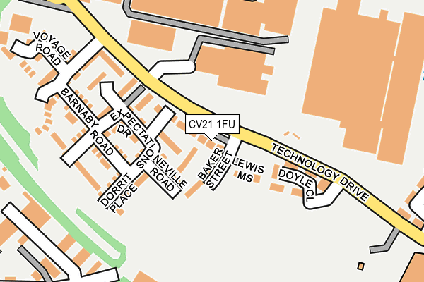
CV21 1FU is located in the Newbold and Brownsover electoral ward, within the local authority district of Rugby and the English Parliamentary constituency of Rugby. The Sub Integrated Care Board (ICB) Location is NHS Coventry and Warwickshire ICB - B2M3M and the police force is Warwickshire. This postcode has been in use since June 2017.


GetTheData
Source: OS OpenMap – Local (Ordnance Survey)
Source: OS VectorMap District (Ordnance Survey)
Licence: Open Government Licence (requires attribution)
| Easting | 450582 |
| Northing | 276387 |
| Latitude | 52.383204 |
| Longitude | -1.258262 |
GetTheData
Source: Open Postcode Geo
Licence: Open Government Licence
| Country | England |
| Postcode District | CV21 |
| ➜ CV21 open data dashboard ➜ See where CV21 is on a map ➜ Where is Rugby? | |
GetTheData
Source: Land Registry Price Paid Data
Licence: Open Government Licence
| Ward | Newbold And Brownsover |
| Constituency | Rugby |
GetTheData
Source: ONS Postcode Database
Licence: Open Government Licence
| January 2024 | Other theft | On or near Petrol Station | 446m |
| December 2023 | Other theft | On or near Petrol Station | 446m |
| November 2023 | Anti-social behaviour | On or near Petrol Station | 446m |
| ➜ Get more crime data in our Crime section | |||
GetTheData
Source: data.police.uk
Licence: Open Government Licence
| Platform 1 (Technology Park) | Rugby | 409m |
| Platform 1 (Technology Drive) | Rugby | 413m |
| Tesco (Private Road) | Rugby | 430m |
| Yates Avenue (Leicester Road) | Rugby | 488m |
| Allen Ford (Leicester Road) | Rugby | 493m |
| Rugby Station | 0.7km |
GetTheData
Source: NaPTAN
Licence: Open Government Licence
➜ Broadband speed and availability dashboard for CV21 1FU
| Percentage of properties with Next Generation Access | 100.0% |
| Percentage of properties with Superfast Broadband | 100.0% |
| Percentage of properties with Ultrafast Broadband | 100.0% |
| Percentage of properties with Full Fibre Broadband | 0.0% |
Superfast Broadband is between 30Mbps and 300Mbps
Ultrafast Broadband is > 300Mbps
| Median download speed | 100.0Mbps |
| Average download speed | 118.0Mbps |
| Maximum download speed | 200.00Mbps |
| Median upload speed | 0.8Mbps |
| Average upload speed | 0.8Mbps |
| Maximum upload speed | 0.78Mbps |
| Percentage of properties unable to receive 2Mbps | 0.0% |
| Percentage of properties unable to receive 5Mbps | 0.0% |
| Percentage of properties unable to receive 10Mbps | 0.0% |
| Percentage of properties unable to receive 30Mbps | 0.0% |
➜ Broadband speed and availability dashboard for CV21 1FU
GetTheData
Source: Ofcom
Licence: Ofcom Terms of Use (requires attribution)
GetTheData
Source: ONS Postcode Database
Licence: Open Government Licence

➜ Get more ratings from the Food Standards Agency
GetTheData
Source: Food Standards Agency
Licence: FSA terms & conditions
| Last Collection | |||
|---|---|---|---|
| Location | Mon-Fri | Sat | Distance |
| Tesco Supermarket | 17:30 | 11:45 | 502m |
| Wood Street Post Office | 17:30 | 12:00 | 509m |
| Boughton Road Post Office | 17:30 | 12:00 | 652m |
GetTheData
Source: Dracos
Licence: Creative Commons Attribution-ShareAlike
| Facility | Distance |
|---|---|
| Nuffield Health (Rugby) Junction One, Leicester Road, Rugby Swimming Pool, Health and Fitness Gym, Studio | 178m |
| Warwickshire College (Rugby Centre) Technology Drive, Rugby Health and Fitness Gym, Sports Hall, Studio, Artificial Grass Pitch | 371m |
| Jd Gyms (Rugby) Newbold Road, Rugby Health and Fitness Gym, Studio | 492m |
GetTheData
Source: Active Places
Licence: Open Government Licence
| School | Phase of Education | Distance |
|---|---|---|
| Northlands Primary School Pinders Lane, Rugby, CV21 2SS | Primary | 751m |
| The Avon Valley School and Performing Arts College Newbold Road, Newbold-on-Avon, Rugby, CV21 1EH | Secondary | 1.1km |
| Riverside Academy Newbold Road, Newbold-on-Avon, Rugby, CV21 1EH | Primary | 1.1km |
GetTheData
Source: Edubase
Licence: Open Government Licence
The below table lists the International Territorial Level (ITL) codes (formerly Nomenclature of Territorial Units for Statistics (NUTS) codes) and Local Administrative Units (LAU) codes for CV21 1FU:
| ITL 1 Code | Name |
|---|---|
| TLG | West Midlands (England) |
| ITL 2 Code | Name |
| TLG1 | Herefordshire, Worcestershire and Warwickshire |
| ITL 3 Code | Name |
| TLG13 | Warwickshire CC |
| LAU 1 Code | Name |
| E07000220 | Rugby |
GetTheData
Source: ONS Postcode Directory
Licence: Open Government Licence
The below table lists the Census Output Area (OA), Lower Layer Super Output Area (LSOA), and Middle Layer Super Output Area (MSOA) for CV21 1FU:
| Code | Name | |
|---|---|---|
| OA | E00158731 | |
| LSOA | E01031141 | Rugby 002E |
| MSOA | E02006493 | Rugby 002 |
GetTheData
Source: ONS Postcode Directory
Licence: Open Government Licence
| CV21 1FW | Expectations Drive | 116m |
| CV21 1FZ | Dorrit Place | 154m |
| CV21 1GB | Barnaby Road | 182m |
| CV21 1FS | Pickwick Place | 184m |
| CV21 1GA | Copperfield Close | 205m |
| CV21 1FQ | Humphrey Close | 234m |
| CV21 1FA | Voyage Road | 272m |
| CV21 1GH | Tainter Close | 288m |
| CV21 1GF | Glebe Farm Road | 304m |
| CV21 1FP | Chimes Court | 310m |
GetTheData
Source: Open Postcode Geo; Land Registry Price Paid Data
Licence: Open Government Licence