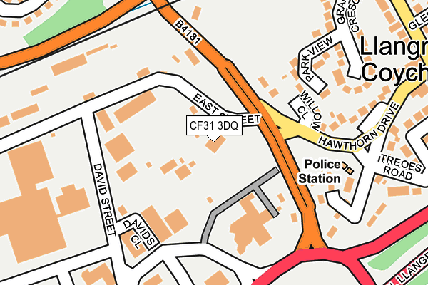
CF31 3DQ is located in the Brackla East and Coychurch Lower electoral ward, within the unitary authority of Bridgend and the Welsh Parliamentary constituency of Bridgend. The Local Health Board is Cwm Taf Morgannwg University and the police force is South Wales. This postcode has been in use since June 2017.


GetTheData
Source: OS OpenMap – Local (Ordnance Survey)
Source: OS VectorMap District (Ordnance Survey)
Licence: Open Government Licence (requires attribution)
| Easting | 293378 |
| Northing | 179426 |
| Latitude | 51.503678 |
| Longitude | -3.537585 |
GetTheData
Source: Open Postcode Geo
Licence: Open Government Licence
| Country | Wales |
| Postcode District | CF31 |
| ➜ CF31 open data dashboard ➜ See where CF31 is on a map ➜ Where is Bridgend? | |
GetTheData
Source: Land Registry Price Paid Data
Licence: Open Government Licence
| Ward | Brackla East And Coychurch Lower |
| Constituency | Bridgend |
GetTheData
Source: ONS Postcode Database
Licence: Open Government Licence
| June 2022 | Criminal damage and arson | On or near Hawthorn Drive | 216m |
| June 2022 | Criminal damage and arson | On or near Parking Area | 225m |
| June 2022 | Drugs | On or near B4181 | 230m |
| ➜ Get more crime data in our Crime section | |||
GetTheData
Source: data.police.uk
Licence: Open Government Licence
| Village Hall (Coychurch Road) | Coychurch | 271m |
| Village Hall (Coychurch Road) | Coychurch | 272m |
| The Waterton Manor (Brocastle Avenue) | Waterton | 417m |
| The Waterton Manor (Brocastle Avenue) | Waterton | 417m |
| Smith Kendon (Brocastle Avenue) | Waterton | 582m |
| Bridgend Station | 2.6km |
| Pencoed Station | 3.5km |
| Wildmill Station | 3.5km |
GetTheData
Source: NaPTAN
Licence: Open Government Licence
GetTheData
Source: ONS Postcode Database
Licence: Open Government Licence


➜ Get more ratings from the Food Standards Agency
GetTheData
Source: Food Standards Agency
Licence: FSA terms & conditions
| Last Collection | |||
|---|---|---|---|
| Location | Mon-Fri | Sat | Distance |
| Bridgend Industrial Estate | 18:30 | 12:00 | 185m |
| Brackla | 17:30 | 12:00 | 1,726m |
| Waunscil Avenue | 17:30 | 12:00 | 2,183m |
GetTheData
Source: Dracos
Licence: Creative Commons Attribution-ShareAlike
| School | Phase of Education | Distance |
|---|---|---|
| Coychurch (Llangrallo) Primary School Main Road, Coychurch, Bridgend, CF35 5HN | Not applicable | 875m |
| Archdeacon John Lewis C.I.W. Primary School, Brackla Way, Brackla, CF31 2JS | Not applicable | 1.4km |
| Archbishop McGrath Catholic High School Oak Tree Way, Brackla, Bridgend, CF31 2DN | Not applicable | 1.5km |
GetTheData
Source: Edubase
Licence: Open Government Licence
The below table lists the International Territorial Level (ITL) codes (formerly Nomenclature of Territorial Units for Statistics (NUTS) codes) and Local Administrative Units (LAU) codes for CF31 3DQ:
| ITL 1 Code | Name |
|---|---|
| TLL | Wales |
| ITL 2 Code | Name |
| TLL1 | West Wales and The Valleys |
| ITL 3 Code | Name |
| TLL17 | Bridgend and Neath Port Talbot |
| LAU 1 Code | Name |
| W06000013 | Bridgend |
GetTheData
Source: ONS Postcode Directory
Licence: Open Government Licence
The below table lists the Census Output Area (OA), Lower Layer Super Output Area (LSOA), and Middle Layer Super Output Area (MSOA) for CF31 3DQ:
| Code | Name | |
|---|---|---|
| OA | W00005314 | |
| LSOA | W01001003 | Bridgend 015D |
| MSOA | W02000232 | Bridgend 015 |
GetTheData
Source: ONS Postcode Directory
Licence: Open Government Licence
| CF35 5HS | Park View | 178m |
| CF35 5EL | 182m | |
| CF35 5EN | Waterton Road | 203m |
| CF35 5ER | Hawthorn Drive | 216m |
| CF35 5HP | Grange Crescent | 256m |
| CF35 5EW | 258m | |
| CF35 5HR | Heol Cae Tyla | 262m |
| CF35 5ES | 273m | |
| CF35 5EY | Bryn Road | 307m |
| CF35 5EP | Brynffrwd Close | 332m |
GetTheData
Source: Open Postcode Geo; Land Registry Price Paid Data
Licence: Open Government Licence