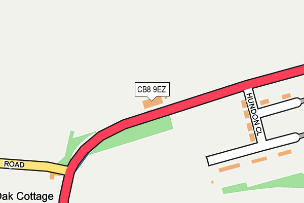
CB8 9EZ is located in the Newmarket West electoral ward, within the local authority district of West Suffolk and the English Parliamentary constituency of West Suffolk. The Sub Integrated Care Board (ICB) Location is NHS Suffolk and North East Essex ICB - 07K and the police force is Suffolk. This postcode has been in use since July 2017.


GetTheData
Source: OS OpenMap – Local (Ordnance Survey)
Source: OS VectorMap District (Ordnance Survey)
Licence: Open Government Licence (requires attribution)
| Easting | 564164 |
| Northing | 263110 |
| Latitude | 52.241711 |
| Longitude | 0.402982 |
GetTheData
Source: Open Postcode Geo
Licence: Open Government Licence
| Country | England |
| Postcode District | CB8 |
| ➜ CB8 open data dashboard ➜ See where CB8 is on a map ➜ Where is Newmarket? | |
GetTheData
Source: Land Registry Price Paid Data
Licence: Open Government Licence
| Ward | Newmarket West |
| Constituency | West Suffolk |
GetTheData
Source: ONS Postcode Database
Licence: Open Government Licence
| January 2024 | Theft from the person | On or near Parking Area | 271m |
| January 2024 | Violence and sexual offences | On or near Kingston Passage | 274m |
| January 2024 | Violence and sexual offences | On or near Kingston Passage | 274m |
| ➜ Get more crime data in our Crime section | |||
GetTheData
Source: data.police.uk
Licence: Open Government Licence
| Bus Shelter (The Avenue) | Newmarket | 88m |
| Bus Shelter (The Avenue) | Newmarket | 101m |
| Horse Racing Museum (High Street) | Newmarket | 241m |
| White Lion (High Street) | Newmarket | 258m |
| Horse Racing Museum (High Street) | Newmarket | 275m |
| Newmarket Station | 0.5km |
| Dullingham Station | 5.1km |
GetTheData
Source: NaPTAN
Licence: Open Government Licence
GetTheData
Source: ONS Postcode Database
Licence: Open Government Licence


➜ Get more ratings from the Food Standards Agency
GetTheData
Source: Food Standards Agency
Licence: FSA terms & conditions
| Last Collection | |||
|---|---|---|---|
| Location | Mon-Fri | Sat | Distance |
| Newmarket Post Office | 18:30 | 12:15 | 148m |
| Fitzroy Street | 17:30 | 11:30 | 259m |
| White Lion | 17:30 | 11:30 | 344m |
GetTheData
Source: Dracos
Licence: Creative Commons Attribution-ShareAlike
| Facility | Distance |
|---|---|
| Newmarket Swimming Pool (Closed) High Street, Newmarket Swimming Pool | 360m |
| Newmarket Town Football Club Cricket Field Road, Newmarket Grass Pitches, Artificial Grass Pitch | 652m |
| Newmarket Lawn Tennis Club Hamilton Road, Newmarket Indoor Tennis Centre, Outdoor Tennis Courts | 733m |
GetTheData
Source: Active Places
Licence: Open Government Licence
| School | Phase of Education | Distance |
|---|---|---|
| Houldsworth Valley Primary Academy Rowley Drive, Newmarket, CB8 0PU | Primary | 566m |
| All Saints Church of England Primary School, Newmarket Vicarage Road, Newmarket, CB8 8JE | Primary | 589m |
| Ditton Lodge Primary School St Johns Avenue, Newmarket, CB8 8BL | Primary | 704m |
GetTheData
Source: Edubase
Licence: Open Government Licence
The below table lists the International Territorial Level (ITL) codes (formerly Nomenclature of Territorial Units for Statistics (NUTS) codes) and Local Administrative Units (LAU) codes for CB8 9EZ:
| ITL 1 Code | Name |
|---|---|
| TLH | East |
| ITL 2 Code | Name |
| TLH1 | East Anglia |
| ITL 3 Code | Name |
| TLH14 | Suffolk CC |
| LAU 1 Code | Name |
| E07000245 | West Suffolk |
GetTheData
Source: ONS Postcode Directory
Licence: Open Government Licence
The below table lists the Census Output Area (OA), Lower Layer Super Output Area (LSOA), and Middle Layer Super Output Area (MSOA) for CB8 9EZ:
| Code | Name | |
|---|---|---|
| OA | E00152501 | |
| LSOA | E01029925 | Forest Heath 008A |
| MSOA | E02006826 | Forest Heath 008 |
GetTheData
Source: ONS Postcode Directory
Licence: Open Government Licence
| CB8 9AA | The Avenue | 60m |
| CB8 9AU | Queensberry Road | 88m |
| CB8 9AQ | High Street | 124m |
| CB8 9AF | High Street | 128m |
| CB8 9AE | Queensberry Mews | 139m |
| CB8 8JH | High Street | 148m |
| CB8 9AH | High Street | 172m |
| CB8 9AP | High Street | 191m |
| CB8 0FH | Abernant Drive | 195m |
| CB8 9AG | High Street | 203m |
GetTheData
Source: Open Postcode Geo; Land Registry Price Paid Data
Licence: Open Government Licence